
Chikmagalur district
Chikmagalur district
Chikmagaluru | |
|---|---|
district | |
| Government | |
| • Deputy Commissioner | Sri. Harsha Gupta |
| Population (2001) | |
| • Total | 1,139,104 |
| Website | chickmagalur.nic.in Chikmagalur.nic.in |

Chikkamagaluru (ಚಿಕ್ಕಮಗಳೂರು in Kannada, pronounced chikkamagaluru), is a district in the Indian state of Karnataka. It literally means City of the younger daughter in Kannada. It is sometimes called Chikmanglur. It has a population of 1,140,905 of which 19.52% are urban. The founders of the Hoysala empire originated from Angadi, a village in this district.
Geography
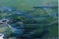
Chikmagaluru, the district head quarters of Chikmagalur district is 251 km from the state capital of Bangalore and surrounded by the Baba Budangiri hills and dense forests. The rivers Bhadra, Tunga, Hemavathi, Nethravathi, and Vedavathi flow all year round. The district is rich in iron, magnetite and granite deposits. The name Chikmagalur is synonymous with verdant forests, beautiful water falls, cool coffee estates and charming temples tucked away in the mountains.
Economy
Coffee is the major commercial crop and is the crucial pillar of Chikmagalur's economy. Sky kissing mountains of chikmagalur, Green carpet finish with forests on them & coffee estates welcomes you to the heaven on earth. Other commercial crops are pepper, cashew,areca nut etc. Recently, there has been a growing interest in developing the district as a nature seekers' paradise. The jungle lodges and resorts cater to lovers of wildlife who seek the pristine beauty of the hills.
How to reach Chikamagalur?
Reachable by Road/Train from Bangalore. Bus journey takes 5.5 hrs either via Kadur(NH206) or Hassan(NH48). Train journey takes almost 3 to 3.5 hrs(till Kadur/Birur), As of now there is no direct connectivity by train (Rail line between Kadur and Chikkamagaluru is under construction), One need to alight at Kadur/Birur and take bus to Chikmagalur for (40KM) 45 minutes.
Tourist spots
Hill Stations
Kemmangundi: 55 km north from Chikmagalur town is Kemmangundi, a scenic hill station on the Baba Budan range of hills. Kemmangundi is also known as K.R. Hills after the Wodeyar King, Krishnaraja Wodeyar, who had made it his favourite summer camp. Kemmangundi, at a height of 1,434 meters, is surrounded by thick forests and a salubrious climate through out the year. It is surrounded by the Baba Budangiri range and blessed with silver cascades of mountain streams and lush vegetation. Its beautifully laid out ornamental gardens and enchanting mountain and valley views are a treat to the eye. Spectacular sunsets are a must see from various locations in the district, even from the Raj Bhavan. For the adventurous, Kemmangundi offers many peaks to scale and intricate jungle paths to explore. This place has a beautiful rose garden and other attractions. There is a place called Z-point at about 10 minutes walk from this main place which gives a nice ariel view of the Shola grass lands of the Western Ghats.
Kudremukh and Kudremukh National Park: 95 km southwest of Chikmagalur town is Kudremukh range (in Kannada Kudure = horse and mukha = face), so named because of the unique shape of the Kudremukh peak. Overlooking the Arabian sea, the broad hills are chained to one another with deep valley & steep precipices. Situated at 1,894.3 meters above sea level, Kudremukh is rich in iron ore deposits. The Kudremukh Iron Ore Company conducts mining operations, benefaction and transportation of the ore as slurry through pipelines to the port at Panambar near Mangalore.
Mullayanagiri: Mullayanagiri is part of the Baba Budan Giri Hill Ranges here. It stands 1930 meters tall and is the tallest peak in Karnataka. Its height is famous mostly for watching sunsets from. It is 6 km from Chikmagalur town. Driving to Mullayanagiri is worth taking a risk. On the way is Sitalayanagiri where the water in the Shiva temple neither increases nor decreases. The road to Mullayanagiri is very narrow with a views from steep cliffs. Driving to the peak is not possible and includes a trek up the hill from the half way point. There is a small temple on top of the hill. From the topmost point of the hill the Arabian sea is visible on clear days. The small hillock in the temple compound is the highest point in Karnataka. The narrow road to the temple makes two way traffic immpossible. It is a great trekking spot in Karnataka.
Baba Budan Range: To the north of Chikmagalur town is the Baba Budan Range or Chandra Drona Parvatha as it was known in the ancient times, which has one of the highest mountain peaks between the Himalayas and the Nilgiris. The peak takes its name from the Muslim saint, Baba Budan, who resided here more than 150 years ago. Manikyandhara is water falls near the famous pilgrim centre Baba Budangiri Dattatreya Peetha where water spills down like small balls giving the visitors a memorable shower bath.
Water Falls
Kallathigiri Falls: Just 10 km away from Kemmangundi is Kallahathigiri falls, also known as Kalahasti falls. Water cascades down from the top of the Chandra Drona hill from a height of 122 meters amidst fascinating scenery. There is an old Veerabhadra temple dedicated to Lord Shiva, constructed in a gap between rocks. This temple can be approached after crossing the waterfall.
Hebbe Falls: This beautiful waterfall is over 10 km away from the famous hill station, Kemmangundi. Here water streams down from a height of 168 meters in two stages to form Dodda Hebbe (Big Falls) and Chikka Hebbe (Small Falls).
Temple Towns
Sringeri: 90 km west of Chikmagalur town is Sringeri situated on the banks of Tunga, a Vedic Peetha established by Sri Adi Shankara, the exponent of the Advaita philosophy in 9th Century A.D. It is famous for Vidyashankara Temple originally constructed by the Hoysalas and later completed by the founders of the Vijayanagar Empire and Sharada temple, an early 20th. century addition. In the Vidya Shankara shrine, there are 12 zodiac pillars, which are so constructed that the rays of the sun fall on the pillar corresponding to the month.
Horanadu: Horanadu is 100 km southwest of Chikmagalur and has an ancient Annapoorneshwari Temple, which has been renovated recently. With the installation of the new image of Adi Shakti, now the temple is called Adi-Shaktyatmaka Shri Annapoorneshwari. The place attracts lots of pilgrims who are provided free boarding and lodging by the temple.
Kalasa: Kalasa is 92 km southwest of Chikmagalur and situated on the banks of the river Bhadra, is surrounded by lofty hills of the Western Ghats and is looked upon as one of the pancha-kshetras on the banks of the Bhadra. Close by are the pancha theerthas, the five sacred ponds. On a small hillock here is the Kalaseshwara temple in dedicated to Ishwara, with a Kshetrapala shrine of soap stone in Hoysala style nearby. The Madhawacharya bande, a large boulder at one of the theerthas here, is supposed to have been placed by Shri Madhawacharya the founder of the Dvaita school of philosophy. A statue of this acharya is carved on the upper portion of the rock.
Guru Dattatreya Bababudanswamy Darga: Situated on the Baba Bugan Giri is the Inam Dattatreya Peetha venerated by the Hindus and the Muslims alike. A laterite cave here is believed to have been sanctified by the residence of Dattatreya Swami as well as Hazrat Dada Hayat Mir Khalander. The worship here is conducted by a fakir and the annual jatra or urs is attended by both Hindus and Muslims with great fervors.
Amritapura: 67 km north of Chikmagalur, Amrithapura is known for the Amritheshwara temple built in 1196 A.D by Amriteshwara Dandanayaka, a general of the Hoysala ruler Veera Ballala II. Delicacy of touch, originality of design and fine features have made this temple one of the notable structures of the Hoysala period.
- Annapoorneshwari Temple at Horanadu 100 km from Chikmagalur in the thick forests and valleys of the Western Ghats.
Wildlife
Bhadra Wildlife Sanctuary: Occupying 495 km². of wildlife sanctuary and Project tiger reserve, this region is an important watershed of the Tungabhadra river. The huge reservoir here is the main water supply to several districts in the rain shadow regions of south Karnataka. The forests here are rich in Bamboo and birds species unique to both the Malabar and Sahyadri ranges.
-
Profile, Amritheshwara temple (1196 C.E.) in Amrithapura, Chikmagalur District
-
Navaranga, Amritheshwara temple in Amrithapura
-
Wall carvings, Amritheshwara temple in Amrithapura
-
Wall carvings, Amritheshwara temple in Amrithapura
-
Wall carvings, Amritheshwara temple in Amrithapura
-
 Mountain stream near Sringeri
 -
 Fishes in Tunga river at Vidyashankara temple, Sringeri

