Đất Đỏ district
Appearance
(Redirected from Dat Do)
Đất Đỏ district
Huyện Đất Đỏ | |
|---|---|
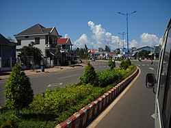
 Đất Đỏ town in Đất Đỏ District | |
 | |
| Country | |
| Region | South East |
| Province | Bà Rịa–Vũng Tàu |
| Capital | Thị trấn Đất Đỏ |
| Area | |
| • Total | 70 sq mi (190 km2) |
| Population (2019 census) | |
| • Total | 73,530 |
| • Density | 1,000/sq mi (390/km2) |
| Time zone | UTC+7 (Indochina Time) |
Đất Đỏ is a rural district of Bà Rịa–Vũng Tàu province in the Southeast region of Vietnam. As of 2019, the district had a population of 73,530.[1][2] The district covers an area of 190 km². The district capital lies at Phước Hải.[2]
This district is the home area of the prominent communist Võ Thị Sáu.
Administrative divisions
[edit]The district is divided administratively into 2 townships: Đất Đỏ, the capital, and Phước Hải. Đất Đỏ contains the following wards: Phước Long Thọ, Long Tân, Láng Dài, Lộc An, Phước Hội and Long Mỹ.
References
[edit]- ^ "Vietnam: Administrative Division (Provinces and Districts) - Population Statistics, Charts and Map". www.citypopulation.de. Retrieved 2024-02-07.
- ^ a b "Districts of Vietnam". Statoids. Retrieved March 13, 2009.

