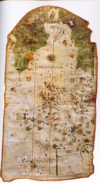
File:1500 map by Juan de la Cosa.jpg
Appearance

Size of this preview: 328 × 600 pixels. Other resolutions: 131 × 240 pixels | 262 × 480 pixels | 420 × 768 pixels | 1,163 × 2,127 pixels.
Original file (1,163 × 2,127 pixels, file size: 3.33 MB, MIME type: image/jpeg)
File history
Click on a date/time to view the file as it appeared at that time.
| Date/Time | Thumbnail | Dimensions | User | Comment | |
|---|---|---|---|---|---|
| current | 04:22, 21 January 2006 |  | 1,163 × 2,127 (3.33 MB) | Taichi | Map of w:en:Juan de la Cosa in 1500. Source: http://tonova.typepad.com/thesuddencurve/historical_blogs/ Category:Historical maps |
File usage
The following 5 pages use this file:
Global file usage
The following other wikis use this file:
- Usage on ca.wikipedia.org
- Usage on cs.wikipedia.org
- Usage on el.wikipedia.org
- Usage on es.wikipedia.org
- América
- Cristóbal Colón
- Américo Vespucio
- Juan de la Cosa
- Portal:Historia/Artículo bueno
- Mapa de Piri Reis
- Era de los Descubrimientos
- Mapamundis antiguos
- Wikipedia:Efemérides/Febrero
- Plantilla:Efemérides - 28 de febrero
- Mapa de Juan de la Cosa
- Plantilla:Portada Bueno/1662
- Mestre Jácome
- Plantilla:Portada Bueno/5009
- Usage on eu.wikipedia.org
- Usage on fr.wikipedia.org
- Usage on gl.wikipedia.org
- Usage on gn.wikipedia.org
- Usage on he.wikipedia.org
- Usage on id.wikipedia.org
- Usage on it.wikipedia.org
- Usage on ja.wikipedia.org
- Usage on ko.wikipedia.org
- Usage on la.wikipedia.org
- Usage on nn.wikipedia.org
- Usage on pl.wikipedia.org
View more global usage of this file.


