
File:1835 S.D.U.K. City Map or Plan of Florence or Firenze, Italy - Geographicus - Florence-SDUK-1835.jpg
Size of this preview: 800 × 591 pixels. Other resolutions: 320 × 237 pixels | 640 × 473 pixels | 1,024 × 757 pixels | 1,280 × 946 pixels | 2,500 × 1,848 pixels.
Original file (2,500 × 1,848 pixels, file size: 1 MB, MIME type: image/jpeg)
| This is a file from the Wikimedia Commons. Information from its description page there is shown below. Commons is a freely licensed media file repository. You can help. |
| William Barnard Clarke: Florence. Firenze.
( |
||||||||||||||||||||
|---|---|---|---|---|---|---|---|---|---|---|---|---|---|---|---|---|---|---|---|---|
| Artist | ||||||||||||||||||||
| Author |
|
|||||||||||||||||||
| Title |
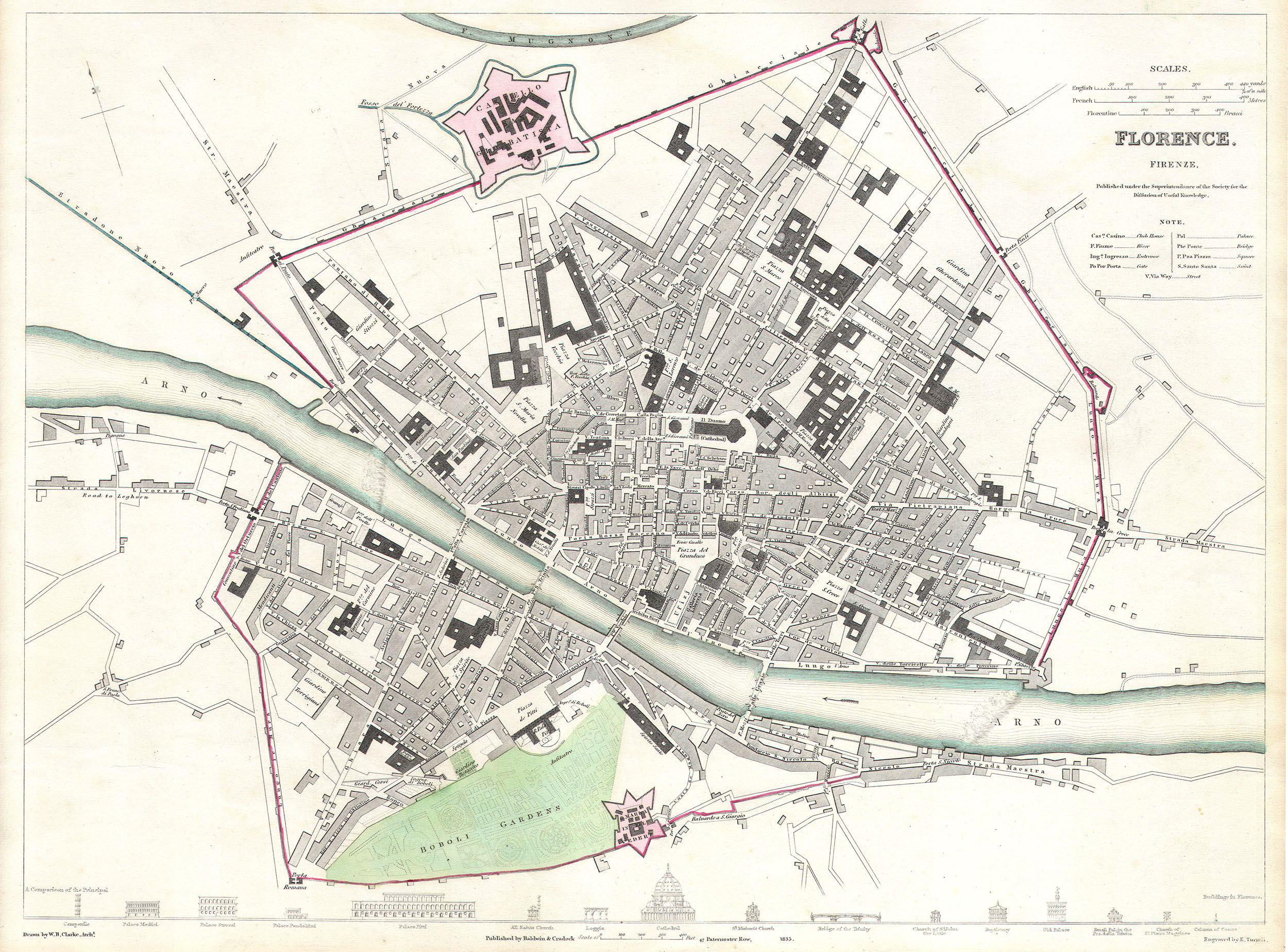
Florence. Firenze. |
|||||||||||||||||||
| Description |
English: This map is a steel plate engraving, dating to 1835 by the Society for the Diffusion of Useful Knowledge, S.D.U.K. It represents the city of Florence or Firenze, Italy. Depicts the old city of Firenze in considerable detail and give attention to most important streets, buildings and monuments. Along the bottom of the map there appears drawings of the facades of 16 Florentine structures entitled A comparison of the principal buildings in Florence. Published for the Society for the Diffusion of Useful Knowledge, by Baldwin and Cradock of Paternoster Row, London, 1835. |
|||||||||||||||||||
| Date | 1835 | |||||||||||||||||||
| Dimensions | height: 12 in (30.4 cm); width: 15 in (38.1 cm) | |||||||||||||||||||
| Accession number |
Geographicus link: Florence-SDUK-1835 |
|||||||||||||||||||
| Source/Photographer |
Maps of the Society for the Diffusion of Useful Knowledge. Vol1. 1844.
|
|||||||||||||||||||
| Permission (Reusing this file) |
|
|||||||||||||||||||
File history
Click on a date/time to view the file as it appeared at that time.
| Date/Time | Thumbnail | Dimensions | User | Comment | |
|---|---|---|---|---|---|
| current | 18:52, 24 March 2011 | | 2,500 × 1,848 (1 MB) | BotMultichillT | {{subst:User:Multichill/Geographicus |link=http://www.geographicus.com/P/AntiqueMap/Florence-SDUK-1835 |product_name=1835 S.D.U.K. City Map or Plan of Florence or Firenze, Italy |map_title=Florence. Firenze. |description=This map is a steel plate engravin |
File usage
The following pages on the English Wikipedia use this file (pages on other projects are not listed):
Global file usage
The following other wikis use this file:
- Usage on de.wikipedia.org
- Usage on gl.wikipedia.org
- Usage on ha.wikipedia.org
- Usage on ko.wikipedia.org
- Usage on mk.wikipedia.org
- Usage on my.wikipedia.org
- Usage on ro.wikipedia.org
- Usage on sl.wikipedia.org
- Usage on tr.wikipedia.org
- Usage on vi.wikipedia.org