
File:1853 U.S.C.S. Map of the North Edisto River, South Carolina - Geographicus - NorthEdistoRiver-uscs-1853.jpg
Size of this preview: 473 × 599 pixels. Other resolutions: 189 × 240 pixels | 379 × 480 pixels | 606 × 768 pixels | 809 × 1,024 pixels | 1,617 × 2,048 pixels | 3,159 × 4,000 pixels.
Original file (3,159 × 4,000 pixels, file size: 1.5 MB, MIME type: image/jpeg)
| This is a file from the Wikimedia Commons. Information from its description page there is shown below. Commons is a freely licensed media file repository. You can help. |
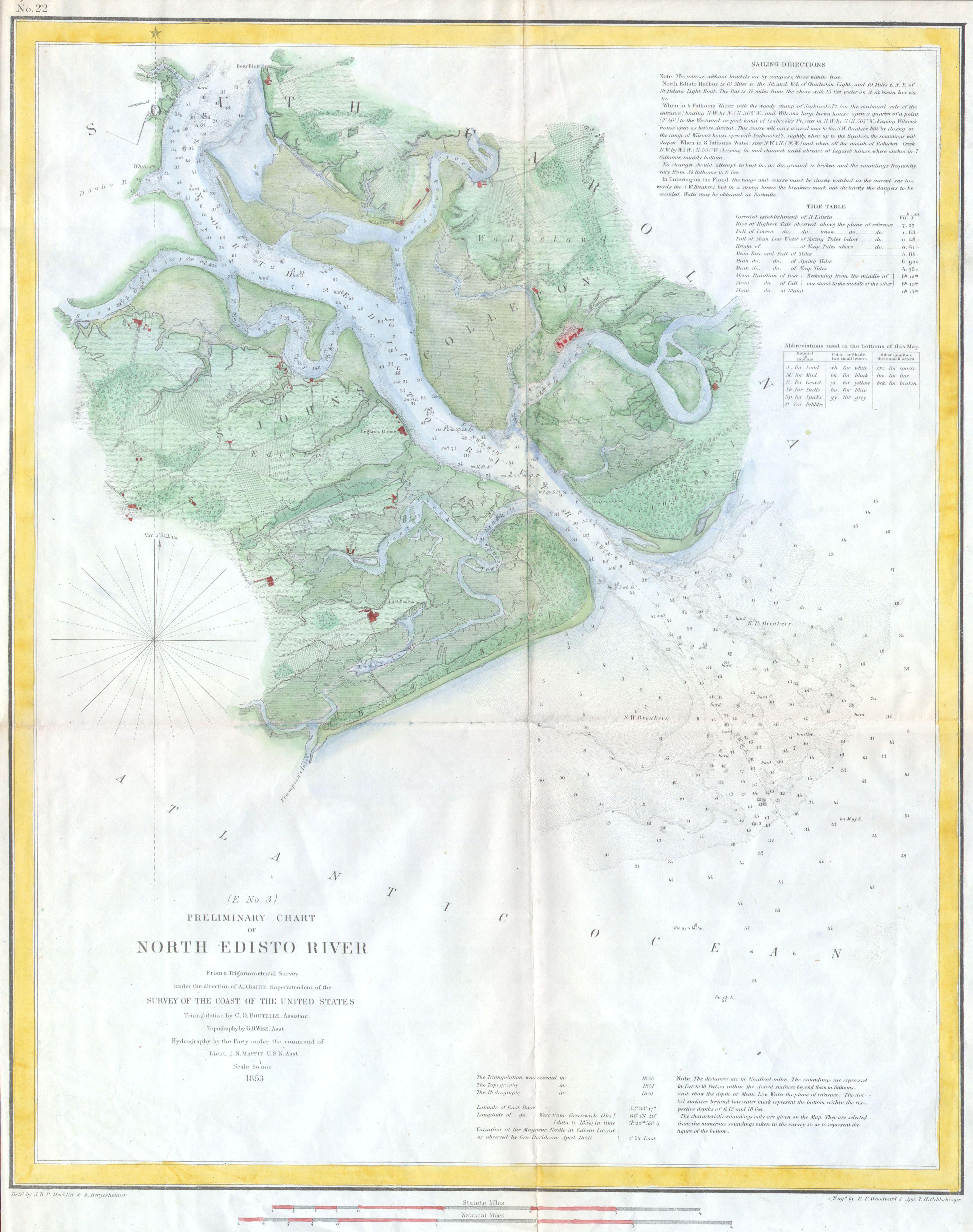
| (E No. 3) Preliminary Chart of North Edisto River. | ||||||
|---|---|---|---|---|---|---|
| Artist | ||||||
| Title |
(E No. 3) Preliminary Chart of North Edisto River. |
|||||
| Description |
English: A rare hand colored 1853 costal chart of South Carolina’s North Edisto River. Features St. John’s Colleton, Seabrook’s Island, Legaro’s House, the town of Rockville, and numerous plantations and private farms. Includes detailed sailing instructions, depth soundings, and impressive inland detail of the region. Today the North Edisto River is a popular vacation destination. Triangulations were accomplished by C. O. Boutelle, topography by G.D. Wise and hydrography by J. N. Maffit. Published under the supervision of A. D. Bache for the 1853 Report of the Superintendant of the U.S. Coast Survey. |
|||||
| Date | 1853 | |||||
| Dimensions | height: 14 in (35.5 cm); width: 17.5 in (44.4 cm) | |||||
| Accession number |
Geographicus link: NorthEdistoRiver-uscs-1853 |
|||||
| Source/Photographer |
|
|||||
| Permission (Reusing this file) |
|
|||||
File history
Click on a date/time to view the file as it appeared at that time.
| Date/Time | Thumbnail | Dimensions | User | Comment | |
|---|---|---|---|---|---|
| current | 20:42, 15 March 2011 | | 3,159 × 4,000 (1.5 MB) | BotMultichill | {{subst:User:Multichill/Geographicus |link=http://www.geographicus.com/P/AntiqueMap/NorthEdistoRiver-uscs-1853 |product_name=1853 U.S.C.S. Map of the North Edisto River, South Carolina |map_title=(E No. 3) Preliminary Chart of North Edisto River. |desc |
File usage
The following pages on the English Wikipedia use this file (pages on other projects are not listed):