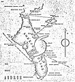
File:1929 Bahamas hurricane Andros Island map.JPG
Appearance

Size of this preview: 549 × 600 pixels. Other resolutions: 220 × 240 pixels | 439 × 480 pixels | 703 × 768 pixels | 937 × 1,024 pixels | 1,768 × 1,932 pixels.
Original file (1,768 × 1,932 pixels, file size: 652 KB, MIME type: image/jpeg)
File history
Click on a date/time to view the file as it appeared at that time.
| Date/Time | Thumbnail | Dimensions | User | Comment | |
|---|---|---|---|---|---|
| current | 16:34, 3 January 2012 |  | 1,768 × 1,932 (652 KB) | Hurricanefan25 | =={{int:filedesc}}== {{Information |description=A handwritten map depicting the 1929 Bahamas hurricane striking Andros Island. |date=2012-01-03 16:32:19(UTC) (Originally uploaded at 2006-04-28 16:35:05) |source=[http://www.aoml.noaa.gov/hrd/hurdat/rosenbe |
File usage
The following page uses this file:
Global file usage
The following other wikis use this file:
- Usage on www.wikidata.org

