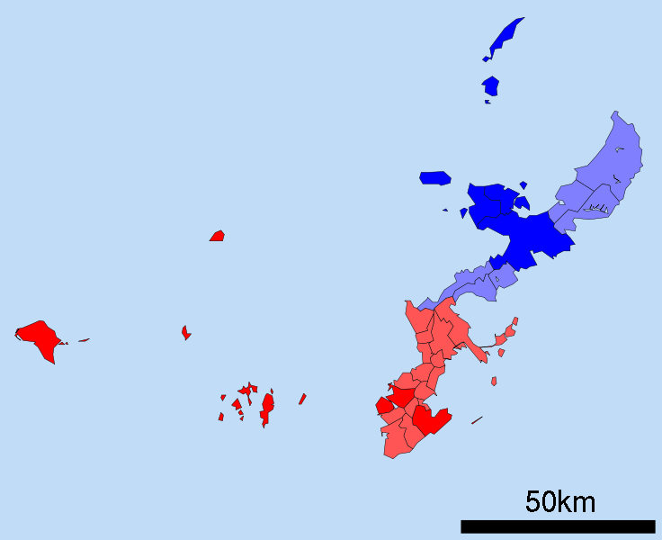
File:Boundaries of the Okinawan Languages.svg
Appearance

Size of this PNG preview of this SVG file: 736 × 600 pixels. Other resolutions: 295 × 240 pixels | 589 × 480 pixels | 942 × 768 pixels | 1,257 × 1,024 pixels | 2,513 × 2,048 pixels.
Original file (SVG file, nominally 800 × 652 pixels, file size: 21 KB)
File history
Click on a date/time to view the file as it appeared at that time.
| Date/Time | Thumbnail | Dimensions | User | Comment | |
|---|---|---|---|---|---|
| current | 00:49, 25 December 2010 |  | 800 × 652 (21 KB) | Io Katai | fixed links |
| 00:47, 25 December 2010 |  | 800 × 652 (21 KB) | Io Katai | Missed out on a few links | |
| 00:41, 25 December 2010 |  | 800 × 652 (21 KB) | Io Katai | {{Information |Description=A map of the Okinawan Islands displaying the distribution of the Northern Okinawan Language (Kunigami) in blue, and the South-Central Okinawan Language (Shuri-Naha) in red. The darker areas represent regions that have been offic |
File usage
The following 2 pages use this file:
Global file usage
The following other wikis use this file:
- Usage on ast.wikipedia.org
- Usage on ca.wikipedia.org
- Usage on cdo.wikipedia.org
- Usage on cs.wikipedia.org
- Usage on et.wikipedia.org
- Usage on fa.wikipedia.org
- Usage on fi.wikipedia.org
- Usage on fr.wikipedia.org
- Usage on gd.wikipedia.org
- Usage on gl.wikipedia.org
- Usage on gn.wikipedia.org
- Usage on haw.wikipedia.org
- Usage on hu.wikipedia.org
- Usage on iba.wikipedia.org
- Usage on id.wikipedia.org
- Usage on incubator.wikimedia.org
- Usage on it.wikipedia.org
- Usage on ja.wikipedia.org
- Usage on ko.wikipedia.org
- Usage on ms.wikipedia.org
- Usage on pt.wikipedia.org
- Usage on ru.wikipedia.org
- Usage on sc.wikipedia.org
- Usage on simple.wikipedia.org
- Usage on si.wikipedia.org
- Usage on sr.wikipedia.org
- Usage on sv.wikipedia.org
- Usage on th.wikipedia.org
- Usage on tr.wikipedia.org
- Usage on uk.wikipedia.org
- Usage on vi.wikipedia.org
- Usage on zh-min-nan.wikipedia.org
- Usage on baike.710302.xyz

