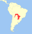
File:Cebus cay distribution.png
Appearance

Size of this preview: 572 × 599 pixels. Other resolutions: 229 × 240 pixels | 458 × 480 pixels | 733 × 768 pixels | 977 × 1,024 pixels | 1,314 × 1,377 pixels.
Original file (1,314 × 1,377 pixels, file size: 146 KB, MIME type: image/png)
File history
Click on a date/time to view the file as it appeared at that time.
| Date/Time | Thumbnail | Dimensions | User | Comment | |
|---|---|---|---|---|---|
| current | 00:14, 18 June 2013 |  | 1,314 × 1,377 (146 KB) | Miguelrangeljr | {{Information |Description ={{en|1=Geographic distribution of the ''Sapajus cay''.}} |Source =Put together by User:Miguelrangeljr using Corel Draw X6. *Base map derived from File:Worldmap location NED 50m.svg (... |
| 00:13, 18 June 2013 |  | 1,314 × 1,377 (146 KB) | Miguelrangeljr | {{Information |Description ={{en|1=Geographic distribution of the ''Sapajus cay''.}} |Source =Put together by User:Miguelrangeljr using Corel Draw X6. *Base map derived from File:Worldmap location NED 50m.svg (... |
File usage
The following 3 pages use this file:
Global file usage
The following other wikis use this file:
- Usage on avk.wikipedia.org
- Usage on bg.wikipedia.org
- Usage on ca.wikipedia.org
- Usage on ceb.wikipedia.org
- Usage on es.wikipedia.org
- Usage on fa.wikipedia.org
- Usage on fr.wikipedia.org
- Usage on nl.wikipedia.org
- Usage on nv.wikipedia.org
- Usage on pt.wikipedia.org
- Usage on ru.wikipedia.org
- Usage on www.wikidata.org

