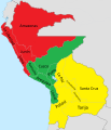
File:Divisiones administrativas de la Confederación Perú-Boliviana.svg
Appearance

Size of this PNG preview of this SVG file: 514 × 599 pixels. Other resolutions: 206 × 240 pixels | 412 × 480 pixels | 659 × 768 pixels | 878 × 1,024 pixels | 1,757 × 2,048 pixels | 1,230 × 1,434 pixels.
Original file (SVG file, nominally 1,230 × 1,434 pixels, file size: 844 KB)
File history
Click on a date/time to view the file as it appeared at that time.
| Date/Time | Thumbnail | Dimensions | User | Comment | |
|---|---|---|---|---|---|
| current | 02:39, 22 July 2020 |  | 1,230 × 1,434 (844 KB) | Janitoalevic | Detalles |
| 02:19, 22 July 2020 |  | 1,230 × 1,434 (862 KB) | Janitoalevic | + Huaylas & Oruro. * Límites mejorados. | |
| 00:24, 1 December 2019 |  | 1,230 × 1,434 (817 KB) | Janitoalevic | . | |
| 00:20, 1 December 2019 |  | 1,230 × 1,434 (816 KB) | Janitoalevic | Added Litoral and Tarija. | |
| 00:20, 1 December 2019 |  | 1,230 × 1,434 (800 KB) | Janitoalevic | . | |
| 01:11, 28 August 2019 |  | 1,230 × 1,434 (816 KB) | Janitoalevic | fixed coastline | |
| 00:00, 28 August 2019 |  | 1,230 × 1,434 (816 KB) | Janitoalevic | User created page with UploadWizard |
File usage
The following 3 pages use this file:
Global file usage
The following other wikis use this file:
- Usage on de.wikipedia.org
- Usage on es.wikipedia.org
- Usage on ja.wikipedia.org
- Usage on ru.wikipedia.org
- Usage on tr.wikipedia.org

