
File:Elworthy Barrows Somerset Map.jpg
No higher resolution available.
Elworthy_Barrows_Somerset_Map.jpg (300 × 300 pixels, file size: 16 KB, MIME type: image/jpeg)
| This is a file from the Wikimedia Commons. Information from its description page there is shown below. Commons is a freely licensed media file repository. You can help. |
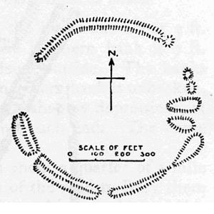
Summary
| Description | Map of earthworks at Elworthy Barrows, Exmoor, Somerset, England. |
| Date | |
| Source | The Victoria History of the Counties of England, A History Of Somerset, Volume 2. |
| Author | Editor - W.Page; Chapter on Ancient Earthworks - C.H.Bothamley |
| Permission (Reusing this file) |
Copyright has expired in the United Kingdom, and is believed to be in the public domain. |
| Openstreetmap entry | Link to Openstreetmap |
| Object location | | View this and other nearby images on: OpenStreetMap |
|---|
Licensing
|
This work is in the public domain in its country of origin and other countries and areas where the copyright term is the author's life plus 70 years or fewer. | |
| This file has been identified as being free of known restrictions under copyright law, including all related and neighboring rights. | |
File history
Click on a date/time to view the file as it appeared at that time.
| Date/Time | Thumbnail | Dimensions | User | Comment | |
|---|---|---|---|---|---|
| current | 21:53, 21 December 2006 | | 300 × 300 (16 KB) | Mikhailfranco~commonswiki | {{Information |Description=Map of earthworks at Elworthy Barrows, Exmoor, Somerset, England. |Source=The Victoria History of the Counties of England, A History Of Somerset, Volume 2. |Date=1911 |Author=Editor - W.Page; Chapter on Ancient Earthworks - C.H. |
File usage
The following pages on the English Wikipedia use this file (pages on other projects are not listed):
Global file usage
The following other wikis use this file:
- Usage on www.wikidata.org