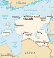
File:En-map.png
Appearance
En-map.png (326 × 350 pixels, file size: 12 KB, MIME type: image/png)
File history
Click on a date/time to view the file as it appeared at that time.
| Date/Time | Thumbnail | Dimensions | User | Comment | |
|---|---|---|---|---|---|
| current | 17:06, 30 October 2021 |  | 326 × 350 (12 KB) | Lojwe | Cropped 1 % horizontally, 1 % vertically using CropTool with precise mode. |
| 14:47, 3 December 2004 |  | 330 × 355 (12 KB) | Kneiphof | CIA Estonia map, PD |
File usage
The following 7 pages use this file:
Global file usage
The following other wikis use this file:
- Usage on be-tarask.wikipedia.org
- Usage on da.wikipedia.org
- Usage on dsb.wikipedia.org
- Usage on el.wikipedia.org
- Usage on en.wiktionary.org
- Usage on es.wikivoyage.org
- Usage on et.wikipedia.org
- Usage on fi.wikivoyage.org
- Usage on fr.wikipedia.org
- Usage on gl.wikipedia.org
- Usage on hu.wikipedia.org
- Lettország
- Észtország
- Litvánia
- Észt nyelv
- Lett nyelv
- Litván nyelv
- Riga
- Liepāja
- Vilnius
- Tallinn
- Kurzeme
- Latgale
- Zemgale
- Sēlija
- Vidzeme
- Daugavpils
- Klaipėda
- Jelgava
- Jūrmala
- Sablon:Észtország-térkép
- Harjumaa
- Järvamaa
- Läänemaa
- Pärnumaa
- Võro nyelv
- Tartu
- Saaremaa
- Narva (település)
- Kaunas
- Võrumaa
- Mulgi nyelv
- Latgal nyelv
- Szetu nyelv
- Szamogit nyelv
View more global usage of this file.


