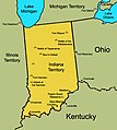
File:Indiana Territory 1812.jpg
Appearance

Size of this preview: 469 × 599 pixels. Other resolutions: 188 × 240 pixels | 495 × 632 pixels.
Original file (495 × 632 pixels, file size: 182 KB, MIME type: image/jpeg)
File history
Click on a date/time to view the file as it appeared at that time.
| Date/Time | Thumbnail | Dimensions | User | Comment | |
|---|---|---|---|---|---|
| current | 03:37, 17 January 2009 |  | 495 × 632 (182 KB) | Charles Edward | {{Information |Description=an updated map, cropped, with locations added, misplaced label moved |Source= |Date=1-16-9 |Author=User:Charles Edward |Permission={{pd-self}} |other_versions= }} |
| 03:31, 17 January 2009 |  | 495 × 632 (183 KB) | Charles Edward | {{Information |Description=an updated map, cropped, with locations added |Source= |Date=1-16-9 |Author=User:Charles Edward |Permission={{pd-self}} |other_versions= }} | |
| 03:30, 17 January 2009 |  | 600 × 670 (205 KB) | Charles Edward | {{Information |Description=an updated map, cropped, with locations added |Source= |Date=1-16-9 |Author=User:Charles Edward |Permission={{pd-self}} |other_versions= }} | |
| 01:25, 17 January 2009 |  | 600 × 670 (205 KB) | Charles Edward | {{Information |Description={{en|1=A map of the Indiana Territory in 1812 displaying notable places and battles in the War of 1812}} |Source=Own work by uploader |Author=Charles Edward |Date=1-16-9 |Permission={{pd-self}} |other_ver |
File usage
The following 4 pages use this file:
Global file usage
The following other wikis use this file:
- Usage on he.wikipedia.org
- Usage on it.wikipedia.org
- Usage on vi.wikipedia.org
