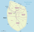
File:Karte Mauke.svg
Appearance

Size of this PNG preview of this SVG file: 626 × 599 pixels. Other resolutions: 251 × 240 pixels | 501 × 480 pixels | 802 × 768 pixels | 1,070 × 1,024 pixels | 2,140 × 2,048 pixels | 865 × 828 pixels.
Original file (SVG file, nominally 865 × 828 pixels, file size: 175 KB)
File history
Click on a date/time to view the file as it appeared at that time.
| Date/Time | Thumbnail | Dimensions | User | Comment | |
|---|---|---|---|---|---|
| current | 15:03, 6 September 2022 |  | 865 × 828 (175 KB) | NordNordWest | == {{int:filedesc}} == {{Information |Description= {{de|1=Karte von {{wd|Mauke (Insel)|Mauke}}}} {{en|1=Map of {{w|Mauke}}}} |Source={{Own using}} * [http://www.openstreetmap.org/ OpenStreetMap] data * https://web.archive.org/web/20120730131423/http:/www.maps.gov.ck/tiki-map.php?mapfile=Mauke.map {{ODbL OpenStreetMap}} |Date=2022-09-06 |Author={{U|NordNordWest}} |Permission= |other_versions= }} {{Kartenwerkstatt}} == {{int:license-header}} == {{self|cc-by-sa-2.0}} Category:Mauke [[Categ... |
File usage
The following 7 pages use this file:
Global file usage
The following other wikis use this file:
- Usage on de.wikipedia.org
- Usage on uz.wikipedia.org


