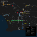
File:Los Angeles County Metro Rail and Metro Liner map.svg
Appearance

Size of this PNG preview of this SVG file: 603 × 599 pixels. Other resolutions: 241 × 240 pixels | 483 × 480 pixels | 773 × 768 pixels | 1,030 × 1,024 pixels | 2,061 × 2,048 pixels | 1,629 × 1,619 pixels.
Original file (SVG file, nominally 1,629 × 1,619 pixels, file size: 1.48 MB)
File history
Click on a date/time to view the file as it appeared at that time.
| Date/Time | Thumbnail | Dimensions | User | Comment | |
|---|---|---|---|---|---|
| current | 19:30, 14 February 2020 |  | 1,629 × 1,619 (1.48 MB) | Pacific Coast Highway | Switched all lines from colors/names to letters to reflect the MTA's new nomenclature. |
| 17:43, 9 December 2019 |  | 1,629 × 1,619 (1.47 MB) | Pacific Coast Highway | Removed Orange Line service to Warner Center | |
| 17:37, 9 December 2019 |  | 1,629 × 1,619 (1.47 MB) | Pacific Coast Highway | Reflects renaming of both the Blue and Expo lines, and 24 hour Metro Liner service. | |
| 14:20, 2 April 2019 |  | 1,629 × 1,619 (2.15 MB) | Dream out loud | updated Burbank Airport area including new station | |
| 01:16, 31 May 2018 |  | 1,629 × 1,619 (1.49 MB) | Pacific Coast Highway | Green Line service restored. | |
| 00:49, 17 February 2018 |  | 1,629 × 1,619 (1.52 MB) | Pacific Coast Highway | ||
| 00:45, 17 February 2018 |  | 512 × 509 (1.52 MB) | Pacific Coast Highway | ||
| 00:43, 17 February 2018 |  | 1,629 × 1,629 (1.53 MB) | Pacific Coast Highway | Reverted to version as of 02:53, 2 June 2016 (UTC) | |
| 00:41, 17 February 2018 |  | 512 × 509 (1.28 MB) | Pacific Coast Highway | Noted Green Line closure and other small visual tweaks. | |
| 02:53, 2 June 2016 |  | 1,629 × 1,629 (1.53 MB) | Pacific Coast Highway | Error fixes. |
File usage
The following 3 pages use this file:
Global file usage
The following other wikis use this file:
- Usage on bs.wikipedia.org
- Usage on de.wikipedia.org
- Usage on en.wikivoyage.org
- Usage on es.wikipedia.org
- Usage on eu.wikipedia.org
- Usage on fa.wikipedia.org
- Usage on fi.wikipedia.org
- Usage on fr.wikipedia.org
- Usage on he.wikivoyage.org
- Usage on hu.wikipedia.org
- Usage on it.wikipedia.org
- Usage on ja.wikipedia.org
- Usage on ko.wikipedia.org
- Usage on oc.wikipedia.org
- Usage on pl.wikipedia.org
- Usage on pl.wikivoyage.org
- Usage on ro.wikipedia.org
- Usage on ru.wikipedia.org
- Usage on th.wikipedia.org
- Usage on tr.wikipedia.org
- Usage on uk.wikipedia.org
- Usage on www.wikidata.org
- Usage on baike.710302.xyz
