Jump to content

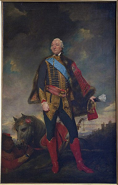
File:Louis Philippe d'Orléans Reynolds Chantilly.jpg

Page contents not supported in other languages.
This is a file from the Wikimedia Commons
From Wikipedia, the free encyclopedia

Original file (2,066 × 3,232 pixels, file size: 4.64 MB, MIME type: image/jpeg)

Summary

anonymous: Q64651987  wikidata:Q64651987 reasonator:Q64651987
Artist
After Joshua Reynolds  (1723–1792)  wikidata:Q194402 s:en:Author:Joshua Reynolds q:en:Joshua Reynolds
 
After Joshua Reynolds
Description British painter, writer, art collector and visual artist
Date of birth/death 16 July 1723 Edit this at Wikidata 23 February 1792 Edit this at Wikidata
Location of birth/death Plympton Edit this at Wikidata London Edit this at Wikidata
Work location
Authority file
artist QS:P170,Q4233718,P1877,Q194402
image of artwork listed in title parameter on this page
Title
Portrait de Louis Philippe Joseph d'Orléans, duc de Chartres, depuis duc d'Orléans
Object type painting
object_type QS:P31,Q3305213
Genre portrait Edit this at Wikidata
Description
Louis Philippe d'Orléans, duc de Chartres (ultérieurement duc d'Orléans, puis Philippe-Egalité), en uniforme de hussards, copie d'après un original disparu
Depicted people Louis Philippe II, Duke of Orléans Edit this at Wikidata
Date circa 1779
date QS:P571,+1779-00-00T00:00:00Z/9,P1480,Q5727902
Medium oil on canvas
medium QS:P186,Q296955;P186,Q12321255,P518,Q861259
Dimensions height: 67 cm (26.3 in); width: 43 cm (16.9 in)
dimensions QS:P2048,67U174728
dimensions QS:P2049,43U174728
institution QS:P195,Q1236032
Accession number
PE 145
Object history
  • Présenté à l'Exposition Universelle de Paris en 1878 ("Des Portraits Nationaux", Palais du Trocadéro)
  • Réalisé en Angleterre. Vente anonyme, Londres, 1830/05/15, n° 11 ; Lawrence sir Thomas (1830) ; Richard Evans (1856) ; duc d' Aumale 1878.
References

Joconde database: entry 00000076619
Olivier Meslay (dir.), L’Art anglais dans les collections de l’Institut de France, Musée Condé / Somogy, 2004, 208 p. (ISBN 2-85056-783-3)

photo.rmn.fr
Authority file
Source/Photographer Own work de Jebulon (talk · contribs)
Camera location49° 11′ 38.8″ N, 2° 29′ 06.8″ E Kartographer map based on OpenStreetMap.View this and other nearby images on: OpenStreetMapinfo

Licensing

This is a faithful photographic reproduction of a two-dimensional, public domain work of art. The work of art itself is in the public domain for the following reason:
Public domain

This work is in the public domain in its country of origin and other countries and areas where the copyright term is the author's life plus 100 years or fewer.


You must also include a United States public domain tag to indicate why this work is in the public domain in the United States.
This file has been identified as being free of known restrictions under copyright law, including all related and neighboring rights.
The official position taken by the Wikimedia Foundation is that "faithful reproductions of two-dimensional public domain works of art are public domain".
This photographic reproduction is therefore also considered to be in the public domain in the United States. In other jurisdictions, re-use of this content may be restricted; see Reuse of PD-Art photographs for details.

This image has been assessed using the Quality image guidelines and is considered a Quality image.

العربية  جازايرية  беларуская  беларуская (тарашкевіца)  български  বাংলা  català  čeština  Cymraeg  Deutsch  Schweizer Hochdeutsch  Zazaki  Ελληνικά  English  Esperanto  español  eesti  euskara  فارسی  suomi  français  galego  עברית  हिन्दी  hrvatski  magyar  հայերեն  Bahasa Indonesia  italiano  日本語  Jawa  ქართული  한국어  kurdî  Lëtzebuergesch  lietuvių  македонски  മലയാളം  मराठी  Bahasa Melayu  Nederlands  Norfuk / Pitkern  polski  português  português do Brasil  rumantsch  română  русский  sicilianu  slovenčina  slovenščina  shqip  српски / srpski  svenska  தமிழ்  తెలుగు  ไทย  Tagalog  toki pona  Türkçe  українська  vèneto  Tiếng Việt  中文  中文(简体)  中文(繁體)  +/−

Captions

Add a one-line explanation of what this file represents

Items portrayed in this file

depicts

49°11'38.800"N, 2°29'6.799"E

0.07692307692307692307 second

35 millimetre

File history

Click on a date/time to view the file as it appeared at that time.

Date/TimeThumbnailDimensionsUserComment
current21:22, 9 July 2011Thumbnail for version as of 21:22, 9 July 20112,066 × 3,232 (4.64 MB)Jebulon

Global file usage

Metadata