
File:Magann's birds eye view map of Pettis County, Missouri - showing plats of the rail road town & sectional county map, 1872 LOC 2012593079.jpg

Size of this preview: 731 × 600 pixels. Other resolutions: 293 × 240 pixels | 585 × 480 pixels | 936 × 768 pixels | 1,248 × 1,024 pixels | 2,497 × 2,048 pixels | 13,868 × 11,377 pixels.
Original file (13,868 × 11,377 pixels, file size: 18.61 MB, MIME type: image/jpeg)
| This is a file from the Wikimedia Commons. Information from its description page there is shown below. Commons is a freely licensed media file repository. You can help. |
Summary
| Warning | The original file is very high-resolution. It might not load properly or could cause your browser to freeze when opened at full size. |
|---|
| Description |
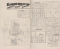
English: Shows names of some residents, boundary lines, and place names. Copy imperfect: Mounted on paper back, folded in half and mended along the fold line. Includes text. Available also through the Library of Congress Web site as a raster image. |
||
| Title | Magann's birds eye view map of Pettis County, Missouri : showing plats of the rail road town & sectional county map, 1872 | ||
| Shelf ID | G4163.P45G46 1872 .M32 | ||
| Date | |||
| Source | https://www.loc.gov/item/2012593079/ | ||
| Author | Magann, J. G. | ||
| Permission (Reusing this file) |
|
||
| Other versions |
|
||
| Location | United States · Pettis County · Missouri | ||
| Part of | American Memory · Catalog · County Landownership Maps · Geography And Map Division · Cultural Landscapes | ||
| Subject | Cadastral Maps · Pettis County · Maps · United States · Pettis County (Mo.) · Missouri · Aerial Views · Landowners |


Licensing
|
This is a faithful photographic reproduction of a two-dimensional, public domain work of art. The work of art itself is in the public domain for the following reason:
The official position taken by the Wikimedia Foundation is that "faithful reproductions of two-dimensional public domain works of art are public domain".
This photographic reproduction is therefore also considered to be in the public domain in the United States. In other jurisdictions, re-use of this content may be restricted; see Reuse of PD-Art photographs for details. | ||||
File history
Click on a date/time to view the file as it appeared at that time.
| Date/Time | Thumbnail | Dimensions | User | Comment | |
|---|---|---|---|---|---|
| current | 10:04, 22 May 2018 | | 13,868 × 11,377 (18.61 MB) | Fæ | LOC Maps https://www.loc.gov/item/2012593079/ #13258 |
File usage
No pages on the English Wikipedia use this file (pages on other projects are not listed).