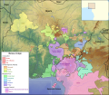
File:Map of the Benue–Congo languages of Nigeria and Cameroon.svg
Appearance

Size of this PNG preview of this SVG file: 687 × 599 pixels. Other resolutions: 275 × 240 pixels | 550 × 480 pixels | 881 × 768 pixels | 1,174 × 1,024 pixels | 2,348 × 2,048 pixels | 1,362 × 1,188 pixels.
Original file (SVG file, nominally 1,362 × 1,188 pixels, file size: 16.58 MB)
File history
Click on a date/time to view the file as it appeared at that time.
| Date/Time | Thumbnail | Dimensions | User | Comment | |
|---|---|---|---|---|---|
| current | 18:36, 14 August 2017 |  | 1,362 × 1,188 (16.58 MB) | SUM1 | Fixed Southern Bantoid boundary (added gaps for Nyong) |
| 14:47, 5 August 2017 |  | 1,362 × 1,188 (16.57 MB) | SUM1 | Fixed Southern Bantoid boundary (near Cross River) | |
| 19:41, 1 August 2017 |  | 1,362 × 1,188 (16.57 MB) | SUM1 | Fixed Chad label | |
| 12:04, 27 July 2017 |  | 1,362 × 1,188 (16.57 MB) | SUM1 | Added O'chi'chi' (Cross River) | |
| 01:12, 27 July 2017 |  | 1,362 × 1,188 (16.57 MB) | SUM1 | Fixed Cross River position and reclassified Bendi as Southern Bantoid | |
| 17:37, 26 July 2017 |  | 1,362 × 1,188 (16.58 MB) | SUM1 | Added Jan Awei language (Jukunoid) | |
| 14:47, 20 July 2017 |  | 1,362 × 1,188 (16.58 MB) | SUM1 | Differenced to prevent further overlap | |
| 14:45, 20 July 2017 |  | 1,362 × 1,188 (16.58 MB) | SUM1 | Fixed Plateau overlap of Kainji | |
| 22:19, 17 July 2017 |  | 1,362 × 1,188 (16.58 MB) | SUM1 | Removed unnecessary layers to reduce file size | |
| 21:17, 17 July 2017 |  | 1,362 × 1,188 (21.07 MB) | SUM1 | Added zoom map |
File usage
The following 2 pages use this file:
Global file usage
The following other wikis use this file:
- Usage on ru.wikipedia.org
