Jump to content

File:Meridian, MS Historic Districts.PNG

Page contents not supported in other languages.
This is a file from the Wikimedia Commons
From Wikipedia, the free encyclopedia

Original file (1,314 × 1,025 pixels, file size: 1.54 MB, MIME type: image/png)

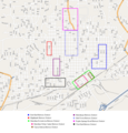
Historic Districts in Meridian, Mississippi

Note: These boundaries are approximate. Districts shown may exclude buildings within the shown perimeter and may include buildings outside the shown perimeter. This map is intended for a general idea of the location/size of the districts. For more precise information, ask the National Park Service for a copy of the individual NRHP nomination forms.

1.

 
East End Historic District — roughly bounded by 18th St, 11th Ave, 14th St, 14th Ave, 5th St, and 17th Ave.

This is an image of a place or building that is listed on the National Register of Historic Places in the United States of America. Its reference number is 87000470.

2.

 
Highlands Historic District — bounded by 15th St, 34th Ave, 19th St, and 36th Ave.

This is an image of a place or building that is listed on the National Register of Historic Places in the United States of America. Its reference number is 87000467.

3.

 
Meridian Downtown Historic District — runs from railroad tracks north to 6th St between 18th and 26th Ave, excluding Ragsdale Survey Block 71.

This is an image of a place or building that is listed on the National Register of Historic Places in the United States of America. Its reference number is 06001249.

4.

 
Meridian Urban Center Historic District — roughly bounded by 21st and 25th Aves, 6th St, and the former Gulf.

This is an image of a place or building that is listed on the National Register of Historic Places in the United States of America. Its reference number is 79003732.

5.

 
Union Station Historic District — roughly bounded by 18th and 19th Aves, 5th St, and the former Gulf, Mobile and Ohio Railroad.

This is an image of a place or building that is listed on the National Register of Historic Places in the United States of America. Its reference number is 79003731.

6.

 
Merrehope Historic District — bounded by 33rd Ave, 30th Ave, 14th St, and 8th St.

This is an image of a place or building that is listed on the National Register of Historic Places in the United States of America. Its reference number is 88000973.

7.

 
Mid-Town Historic District — bounded by 23rd Ave, 15th St, 28th Ave, and 22nd St.

This is an image of a place or building that is listed on the National Register of Historic Places in the United States of America. Its reference number is 87000463.

8.

 
Poplar Springs Road Historic District — roughly bounded by 29th St, 23rd Ave, 22nd St, and 29th Ave.

This is an image of a place or building that is listed on the National Register of Historic Places in the United States of America. Its reference number is 87000461.

9.

 
West End Historic District — roughly bounded by 7th St, 28th Ave, Shearer's Branch, and 5th St.

This is an image of a place or building that is listed on the National Register of Historic Places in the United States of America. Its reference number is 87000459.

Description
Date
Source Base map generated by OpenStreetMap.org. District outlines retrieved from this site.
Author self-made
Permission
(Reusing this file)
Description

OpenStreetMap cut-out (or derivative work based on it):
without further description
This cut-out may be incomplete, and may contain errors, or may be obsolete. Don't rely solely on it for navigation.

See the image in the present state and its original context on the Mississippi OpenStreetMap wiki page for Meridian, Mississippi
Date missing, probably the upload date
Source OpenStreetMap project data
Author OpenStreetMap contributors
Permission
(Reusing this file)

All OpenStreetMap data and maps are licensed under:

w:en:Creative Commons
attribution share alike
This file is licensed under the Creative Commons Attribution-Share Alike 2.0 Generic license.
You are free:
  • to share – to copy, distribute and transmit the work
  • to remix – to adapt the work
Under the following conditions:
  • attribution – You must give appropriate credit, provide a link to the license, and indicate if changes were made. You may do so in any reasonable manner, but not in any way that suggests the licensor endorses you or your use.
  • share alike – If you remix, transform, or build upon the material, you must distribute your contributions under the same or compatible license as the original.

Captions

Add a one-line explanation of what this file represents

Items portrayed in this file

depicts

5 October 2008

image/png

File history

Click on a date/time to view the file as it appeared at that time.

Date/TimeThumbnailDimensionsUserComment
current21:11, 5 October 2008Thumbnail for version as of 21:11, 5 October 20081,314 × 1,025 (1.54 MB)Dudemanfellabra
21:06, 26 May 2008Thumbnail for version as of 21:06, 26 May 20081,386 × 1,204 (709 KB)Dudemanfellabra
17:40, 21 May 2008Thumbnail for version as of 17:40, 21 May 20081,386 × 1,204 (705 KB)Dudemanfellabra'''Historic Districts in Meridian, Mississippi''' <small>{{color box|#0000FF}}</small> East End Historic District — roughly bounded by 18th St, 11th Ave, 14th St, 14th Ave, 5th St, and 17th Ave. <s
21:01, 20 May 2008Thumbnail for version as of 21:01, 20 May 20081,386 × 1,449 (725 KB)Dudemanfellabra{{Information |Description= Map of the Registered Historic Districts in Meridian, MS |Source= Base map generated by [[http://www.openstreetmap.org OpenStreetMap.org] |Date= 20 May 2008 |Author= self-made |Permission= |other_versions= }} {{OpenStreetMapIma

Global file usage

The following other wikis use this file: