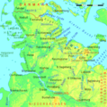
File:Schleswig-Holstein.png
Appearance

Size of this preview: 594 × 599 pixels. Other resolutions: 238 × 240 pixels | 476 × 480 pixels | 761 × 768 pixels | 1,123 × 1,133 pixels.
Original file (1,123 × 1,133 pixels, file size: 165 KB, MIME type: image/png)
File history
Click on a date/time to view the file as it appeared at that time.
| Date/Time | Thumbnail | Dimensions | User | Comment | |
|---|---|---|---|---|---|
| current | 12:14, 21 March 2016 |  | 1,123 × 1,133 (165 KB) | Ulamm | Eider river near Rendsburg corrected |
| 21:49, 21 November 2013 |  | 1,123 × 1,133 (165 KB) | Ulamm | colours | |
| 02:13, 21 November 2013 |  | 1,123 × 1,133 (165 KB) | Ulamm | colours more moderate; + Sorge river | |
| 19:18, 5 February 2008 |  | 1,123 × 1,133 (152 KB) | Ulamm | ||
| 19:02, 5 February 2008 |  | 1,123 × 1,133 (152 KB) | Ulamm | {{Information |Description={{de|Physikalische Karte von Schleswig-Holstein mit Namen von Landschaften, Flüssen und Städten}}{en|physical map of Schleswig-Holstein with names of landscapes, rivers, and cities |Source=http://www.maps-for-free.com |Date= | |
File usage
The following 3 pages use this file:
Global file usage
The following other wikis use this file:
- Usage on als.wikipedia.org
- Usage on arz.wikipedia.org
- Usage on es.wikipedia.org
- Usage on et.wikipedia.org
- Usage on eu.wikipedia.org
- Usage on fr.wikipedia.org
- Usage on mk.wikipedia.org
- Usage on pl.wikipedia.org
- Usage on pl.wikivoyage.org
- Usage on stq.wikipedia.org
- Usage on vi.wikipedia.org
- Usage on vls.wikipedia.org
