File:Shelley rambles map.svg
Appearance

Size of this PNG preview of this SVG file: 232 × 213 pixels. Other resolutions: 261 × 240 pixels | 523 × 480 pixels | 837 × 768 pixels | 1,115 × 1,024 pixels | 2,231 × 2,048 pixels.
Original file (SVG file, nominally 232 × 213 pixels, file size: 1.61 MB)
File history
Click on a date/time to view the file as it appeared at that time.
| Date/Time | Thumbnail | Dimensions | User | Comment | |
|---|---|---|---|---|---|
| current | 17:19, 16 January 2010 |  | 232 × 213 (1.61 MB) | EyeSerene | slight alterations to route lines |
| 10:33, 9 January 2010 |  | 232 × 213 (2.01 MB) | EyeSerene | convert text to path in map scale | |
| 10:29, 9 January 2010 |  | 232 × 213 (1.99 MB) | EyeSerene | Change Treves > Trier; tweak direction lines; some tidying | |
| 23:06, 5 January 2010 |  | 232 × 213 (1.25 MB) | EyeSerene | Tidy up scale; emphasise text slightly | |
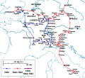
| 22:53, 5 January 2010 |  | 232 × 213 (1.24 MB) | EyeSerene | {{Information |Description={{en|1=Map of Mary Shelley and her son Percy Florence Shelley's travels in 1840 and 1842-1843, taken from The Novels and Selected Works of Mary Shelley. Vol. 8. Ed. Jeanne Moskal. London: William Pickering, 1996, pg. 58-59. The |
File usage
The following 2 pages use this file:
Global file usage
The following other wikis use this file:
- Usage on ar.wikipedia.org
- Usage on fr.wikipedia.org

