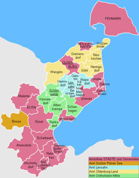
File:Uebersicht-OH.png
Appearance

Size of this preview: 467 × 599 pixels. Other resolutions: 187 × 240 pixels | 570 × 731 pixels.
Original file (570 × 731 pixels, file size: 15 KB, MIME type: image/png)
File history
Click on a date/time to view the file as it appeared at that time.
| Date/Time | Thumbnail | Dimensions | User | Comment | |
|---|---|---|---|---|---|
| current | 13:35, 31 December 2007 |  | 570 × 731 (15 KB) | ClausG | Changes for 2008/01/01 |
| 15:19, 31 December 2006 |  | 570 × 731 (14 KB) | ClausG | ||
| 14:12, 9 December 2006 |  | 570 × 731 (14 KB) | ClausG | ||
| 14:07, 9 December 2006 |  | 570 × 731 (14 KB) | ClausG | == Beschreibung == {{Information |Description={{en|This map shows the Ämter (counties) and Gemeinden (municipalities) in the Kreis (district) Ostholstein in Schleswig-Holstein, Germany.}} {{de|Diese Karte zeigt die Ämter und Gemeinden im Kreis Ostholste |
File usage
The following page uses this file:
Global file usage
The following other wikis use this file:
- Usage on da.wikipedia.org
- Usage on de.wikipedia.org
- Usage on de.wikivoyage.org
- Usage on es.wikipedia.org
- Usage on fa.wikipedia.org
- Usage on frr.wikipedia.org
- Usage on fr.wikipedia.org
- Usage on it.wikipedia.org
- Usage on ms.wikipedia.org
- Usage on nl.wikipedia.org
- Usage on no.wikipedia.org
- Usage on pl.wikipedia.org
- Usage on pt.wikipedia.org
- Usage on ro.wikipedia.org
- Usage on simple.wikipedia.org
- Usage on tr.wikipedia.org
- Usage on uk.wikipedia.org
- Usage on vi.wikipedia.org

