
File:Unioni territoriali intercomunali del Friuli-Venezia Giulia.png
Size of this preview: 600 × 600 pixels. Other resolutions: 240 × 240 pixels | 480 × 480 pixels | 768 × 768 pixels | 1,024 × 1,024 pixels | 1,300 × 1,300 pixels.
Original file (1,300 × 1,300 pixels, file size: 102 KB, MIME type: image/png)
| This is a file from the Wikimedia Commons. Information from its description page there is shown below. Commons is a freely licensed media file repository. You can help. |
Summary
| Description |
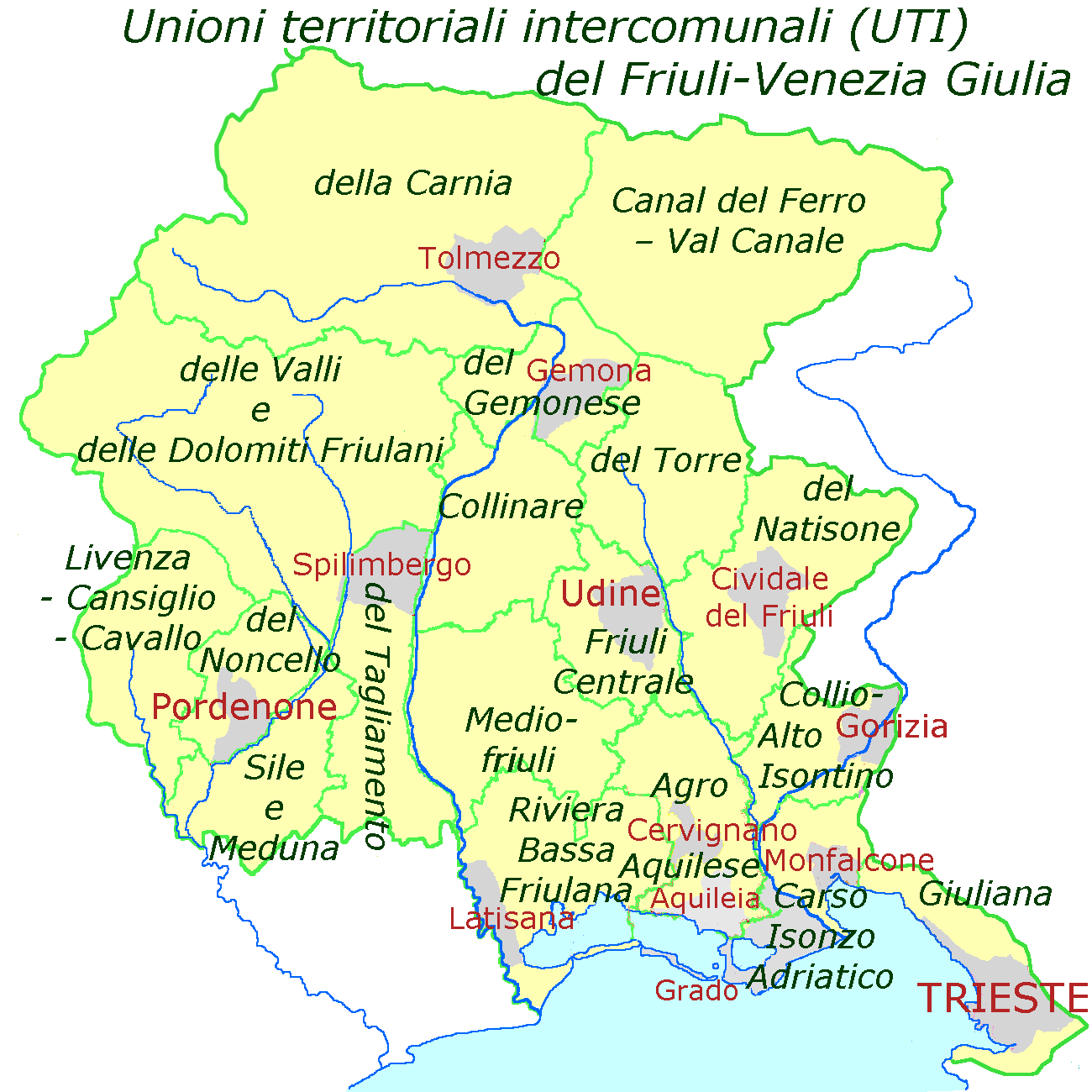
English: Map of Friuli-Venezia Giulia with the new subdivisions "Unioni territoriali intercomunali", estabished in the beginning of 2018 |
|||||||||||||||
| Date | ||||||||||||||||
| Source |
map of
|
|||||||||||||||
| Author | Ulamm (talk) |
Licensing
I, the copyright holder of this work, hereby publish it under the following licenses:

|
Permission is granted to copy, distribute and/or modify this document under the terms of the GNU Free Documentation License, Version 1.2 or any later version published by the Free Software Foundation; with no Invariant Sections, no Front-Cover Texts, and no Back-Cover Texts. A copy of the license is included in the section entitled GNU Free Documentation License. |
This file is licensed under the Creative Commons Attribution-Share Alike 4.0 International, 3.0 Unported, 2.5 Generic, 2.0 Generic and 1.0 Generic license.
- You are free:
- to share – to copy, distribute and transmit the work
- to remix – to adapt the work
- Under the following conditions:
- attribution – You must give appropriate credit, provide a link to the license, and indicate if changes were made. You may do so in any reasonable manner, but not in any way that suggests the licensor endorses you or your use.
- share alike – If you remix, transform, or build upon the material, you must distribute your contributions under the same or compatible license as the original.
You may select the license of your choice.
File history
Click on a date/time to view the file as it appeared at that time.
| Date/Time | Thumbnail | Dimensions | User | Comment | |
|---|---|---|---|---|---|
| current | 08:07, 24 July 2019 | | 1,300 × 1,300 (102 KB) | Luigib25 | Aggiunto Comune di Sappada |
| 21:52, 18 July 2018 |  | 1,300 × 1,300 (88 KB) | Ulamm | totally recoloured | |
| 15:34, 16 July 2018 |  | 1,300 × 1,300 (92 KB) | Ulamm | now definite instead of projected names and borders | |
| 10:08, 16 July 2018 |  | 1,300 × 1,300 (84 KB) | Ulamm | outline corrected | |
| 09:11, 16 July 2018 |  | 1,300 × 1,300 (88 KB) | Ulamm | once more ;) | |
| 09:09, 16 July 2018 |  | 1,300 × 1,300 (87 KB) | Ulamm | once more + title | |
| 02:18, 16 July 2018 |  | 1,300 × 1,300 (83 KB) | Ulamm | + Isonzo | |
| 00:52, 16 July 2018 |  | 1,300 × 1,300 (80 KB) | Ulamm | title | |
| 00:46, 16 July 2018 |  | 1,300 × 1,300 (76 KB) | Ulamm | {{Information |Description={{en|Map of Friuli-Venezia Giulia with the new subdivisions "Unioni territoriali intercomunali", estabished in the beginning of 2018}} |Source=map of {{Openstreetmap}} an information of 26109_unioniTerritorialiIntercomunali4feb15.pdf |Date=2018-07-16 |Author=~~~ |Permission= |other_versions= }} Category:Maps of Friuli-Venezia Giulia Category:Maps of subdivisions of Italy Category:2018 maps of Europe Category:Maps by Ulamm |
File usage
The following page uses this file:
Global file usage
The following other wikis use this file:
- Usage on de.wikipedia.org
- Usage on es.wikipedia.org
- Usage on fr.wikipedia.org
- Usage on it.wikipedia.org
- Usage on nl.wikipedia.org
- Usage on no.wikipedia.org
- Usage on pl.wikipedia.org
- Usage on ru.wikipedia.org
- Usage on sl.wikipedia.org