
File:Bisons.JPG

Size of this preview: 684 × 600 pixels. Other resolutions: 274 × 240 pixels | 547 × 480 pixels | 876 × 768 pixels | 1,262 × 1,107 pixels.
Original file (1,262 × 1,107 pixels, file size: 313 KB, MIME type: image/jpeg)
| This is a file from the Wikimedia Commons. Information from its description page there is shown below. Commons is a freely licensed media file repository. You can help. |
Summary
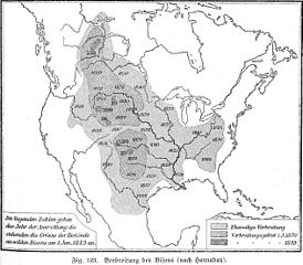
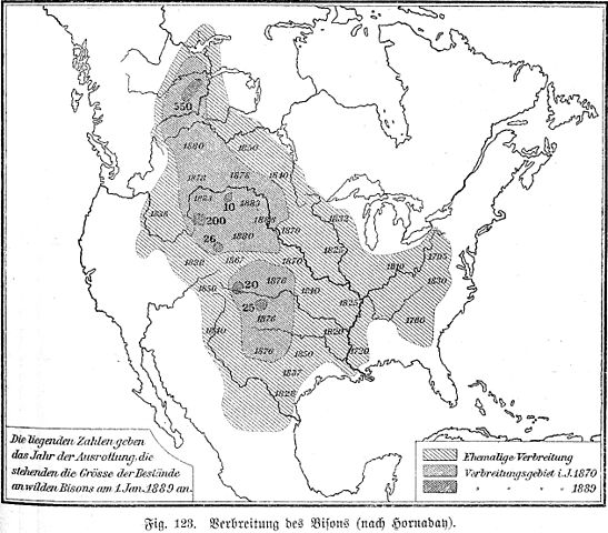
The areas where the Bisons lived by the end of the 19. century. The map is drawn by William Temple Hornaday.
I scanned the picture from: "Geographisches Handbuch zu Andrees Handatlas, vierte Auflage, Bielefeld und Leipzig, Velhagen und Klasing, 1902".
The image was superceded by:

|
This file has been superseded by Extermination of bison to 1889.png. It is recommended to use the other file. Please note that deleting superseded images requires consent.
|

|
Licensing
|
This work is in the public domain in its country of origin and other countries and areas where the copyright term is the author's life plus 70 years or fewer. | |
| This file has been identified as being free of known restrictions under copyright law, including all related and neighboring rights. | |
File history
Click on a date/time to view the file as it appeared at that time.
| Date/Time | Thumbnail | Dimensions | User | Comment | |
|---|---|---|---|---|---|
| current | 12:12, 11 December 2009 | | 1,262 × 1,107 (313 KB) | Alex:D | whitened |
| 08:21, 29 January 2007 |  | 1,262 × 1,107 (325 KB) | Olahus | The areas where the Bissons lived by the end of the 19. century. The map was designed by William Temple Hornaday. I scanned the picture from: "Geographisches Handbuch zu Andrees Handatlas, vierte Auflage, Bielefend und Leipzig, Velhagen und Klasing, |
File usage
The following pages on the English Wikipedia use this file (pages on other projects are not listed):
Global file usage
The following other wikis use this file:
- Usage on fr.wikipedia.org
- Usage on ja.wikipedia.org
- Usage on ro.wikipedia.org
- Usage on ru.wikipedia.org