From Wikipedia, the free encyclopedia
Original file (1,271 × 1,085 pixels, file size: 96 KB, MIME type: image/png )
Summary
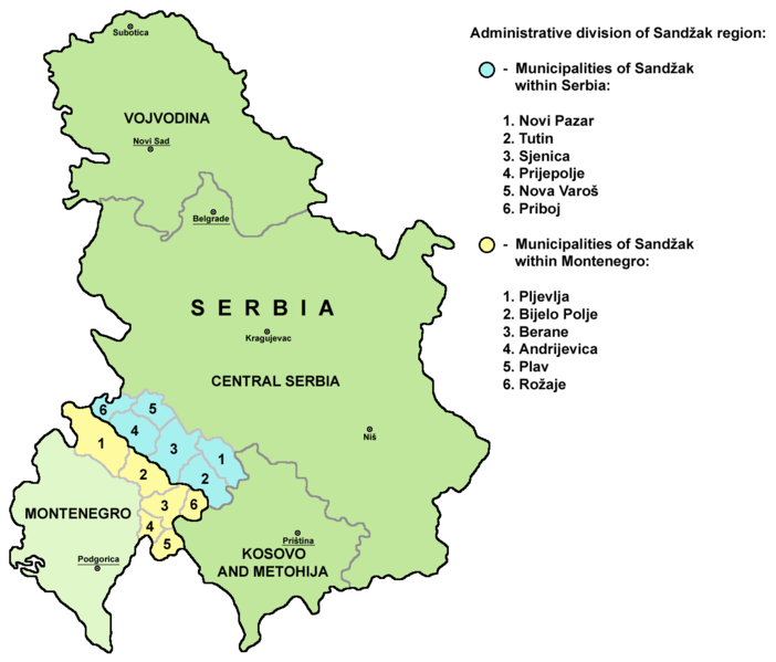
A map of administrative division of the Sandžak region (divided between Serbia and Montenegro).
Mapa administrativne podele regiona Sandžak (podeljenog između Srbije i Crne Gore).
Licensing
Released into the public domain on the English Wikipedia, by its author PANONIAN.
Public domain Public domain false false
This work has been released into the public domain PANONIAN , at the English Wikipedia projectIn case this is not legally possible: PANONIAN grants anyone the right to use this work for any purpose , without any conditions, unless such conditions are required by law.
References
Dr Tomislav Bogavac, Nestajanje Srba, Niš, 1994.
http://www.bihor-petnica.com/Sandzak_Karta-zuta.gif http://www.bihor-petnica.com/sandzak-manja%20karta.jpg http://data36.sevenload.com/slcom/ww/mc/ciienk/eqzhjljbcdc.jpg http://www.radiosandzak.eu/FotoSandzaka/KartaSANDZAK.jpg http://www.bihor-petnica.com/Sandzak_u_Jugoslaviji.gif http://i1234.photobucket.com/albums/ff403/kedza1/BNV/PolozajSandzaka.jpg http://ligazasandzak.org/wp-content/uploads/2012/08/sandzak1.jpg http://sandzakbiznis.com/wordpress/sandzak.jpg http://api.ning.com/files/t7Mn40e4xGQfrLqZ9-1YGqqsl-TwYabCClIbqEOmuiBuVw7w1oO3KsZQzvrZF5gZPNhldyWJE-0zbOgJ9gXLQMezEgWVdtuV/Sandzakkartanova.jpg http://www.magasinetroest.dk/uploads/pics/Sandzak.jpg http://publishing.cdlib.org/ucpressebooks/data/13030/47/kt2k401947/figures/kt2k401947_fig003.gif http://t0.gstatic.com/images?q=tbn:ANd9GcQ1SPbXT6Y7H_F5h-sV6Fw0vOrnooACQtY3lyr_eZ4872CfvNnENA&t=1 http://www.orbus.be/religion/islam/images/balkan-sandzak-300.jpg http://api.ning.com/files/aUR14cLVxZ6HUuLPtJyCnPRoHFWqnULDq4rRz3z-RnC2Ax5fZrFiilO-qrfofCtMn37ocGhe618*Ae8**Y7jI-IHym18ouA7/KartaSandzakaiSrbije.jpg Slobodan Radovanović, Geografski atlas, Magic Map, Smederevska Palanka, 2001.
Školski geografski atlas, Intersistem Kartografija, Beograd, 2004.
Miodrag Milošević, Geografija za 8. razred osnovne škole, Beograd, 1994.
Istorijski atlas, Zavod za kartografiju "Geokarta", Beograd, 1999.
Denis Šehić - Demir Šehić, Istorijski atlas sveta, Beograd, 2007.
http://www.lib.utexas.edu/maps/europe/serbia.jpg http://www.geographicguide.net/europe/maps-europe/maps/serbia-montenegro.gif http://i.infoplease.com/images/myugo.gif http://poincare.matf.bg.ac.rs/~geom_workshop/yu1.jpg English Add a one-line explanation of what this file represents
Russian Административное деление региона Санджак
File history
Click on a date/time to view the file as it appeared at that time.
Date/Time Thumbnail Dimensions User Comment current 18:33, 29 November 2013 1,271 × 1,085 (96 KB) WikiEditor2004 Reverted to version as of 15:12, 25 August 2012 - please upload your version under different name, this is substantial difference 15:59, 29 November 2013 1,271 × 1,085 (70 KB) No More Cats updated borders 15:12, 25 August 2012 1,271 × 1,085 (96 KB) WikiEditor2004 improved my own work 17:03, 1 August 2007 783 × 669 (52 KB) Serbish A map of the Sandzak region. (Partially in Serbia, and in Montenegro) Released into the public domain on the English Wikipedia, by PANONIAN . {{PD-user-w|en|English Wikipedia|PANONIAN}} 02:10, 18 October 2006 783 × 669 (52 KB) Cro-Cop2
File usage
The following page uses this file:
Global file usage
The following other wikis use this file:
Usage on ar.wikipedia.org
Usage on ca.wikipedia.org
Usage on el.wikipedia.org
Usage on es.wikipedia.org
Usage on eu.wikipedia.org
Usage on fi.wikipedia.org
Usage on gl.wikipedia.org
Usage on he.wikipedia.org
Usage on hr.wikipedia.org
Usage on hsb.wikipedia.org
Usage on hu.wikipedia.org
Usage on it.wikipedia.org
Usage on ja.wikipedia.org
Usage on ko.wikipedia.org
Usage on lt.wikipedia.org
Usage on mn.wikipedia.org
Usage on mzn.wikipedia.org
Usage on nn.wikipedia.org
Usage on pt.wikipedia.org
Usage on ru.wikipedia.org
Usage on sh.wikipedia.org
Usage on szl.wikipedia.org
Usage on tr.wikipedia.org
Usage on www.wikidata.org


