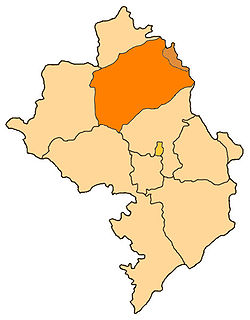
Martakert Province
This article needs to be updated. (April 2022) |
This article needs additional citations for verification. (June 2017) |
Martakert
Մարտակերտ | |
|---|---|
 | |
| Capital | Martakert |
| Government | |
| • Governor | Vladik Khachatryan |
| Area | |
• Total | 1,795 km2 (693 sq mi) |
| • Rank | Ranked 4th |
| Population (2013)[1] | |
• Total | 20,185 |
| • Rank | Ranked 3rd |
| • Density | 11/km2 (29/sq mi) |
| Website | Martakert Province |
Martakert Province (Armenian: Մարտակերտի շրջան) was a de facto province of the Republic of Artsakh, when it was de jure part of the Republic of Azerbaijan. The population was mainly Armenian. The province had 43 communities of which one was considered urban and 42 are rural. It is under control of Azerbaijan since 23 September 2023.
Following the First Nagorno-Karabakh war, the district came under the control of the self-proclaimed. However, following the 2020 Nagorno-Karabakh war, Azerbaijan recaptured parts of the district and after September 2023 offensive they gained the full control of the region.
Settlements
[edit]Cultural sites
[edit]The Gandzasar monastery, the Yeghishe Arakyal Monastery and the 17th century Armenian monastery Yerits Mankants are located in the province. The Vankasar Monastery is just outside the town of Martakert. The archaeological site of Tigranakert of Artsakh is also located in the province, thought to have been founded in the 2nd-1st century B.C, it has been undergoing excavation since 2005. Some of the walls of the city, with Hellenistic-style towers, as well as Armenian basilicas dating to fifth to seventh centuries have been uncovered.
 |
 |
References
[edit]- ^ Census Archived 2009-03-06 at the Wayback Machine

