Portal:North America
The North America Portal

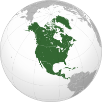
North America is a continent in the Northern and Western Hemispheres. North America is bordered to the north by the Arctic Ocean, to the east by the Atlantic Ocean, to the southeast by South America and the Caribbean Sea, and to the west and south by the Pacific Ocean. The region includes the Bahamas, Bermuda, Canada, the Caribbean, Central America, Clipperton Island, Greenland, Mexico, Saint Pierre and Miquelon, Turks and Caicos Islands, and the United States.
North America covers an area of about 24,709,000 square kilometers (9,540,000 square miles), representing approximately 16.5% of the Earth's land area and 4.8% of its total surface area. It is the third-largest continent by size after Asia and Africa, and the fourth-largest continent by population after Asia, Africa, and Europe. As of 2021[update], North America's population was estimated as over 592 million people in 23 independent states, or about 7.5% of the world's population. In human geography, the terms "North America" and "North American" can refer to Canada, the United States, Mexico, and Greenland or, alternatively, Canada, Greenland and the US (Mexico being classified as part of Latin America) or simply Canada and the US (Greenland being classified as either Arctic or European (due to its political status as a part of Denmark) and Mexico classified as Latin American).
It is unknown with certainty how and when first human populations first reached North America. People were known to live in the Americas at least 20,000 years ago, but various evidence points to possibly earlier dates. The Paleo-Indian period in North America followed the Last Glacial Period, and lasted until about 10,000 years ago when the Archaic period began. The classic stage followed the Archaic period, and lasted from approximately the 6th to 13th centuries. Beginning in 1000 AD, the Norse were the first Europeans to begin exploring and ultimately colonizing areas of North America.
In 1492, the exploratory voyages of Christopher Columbus led to a transatlantic exchange, including migrations of European settlers during the Age of Discovery and the early modern period. Present-day cultural and ethnic patterns reflect interactions between European colonists, indigenous peoples, enslaved Africans, immigrants from Europe, Asia, and descendants of these respective groups. (Full article...)
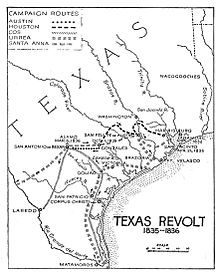
The Texas Revolution (October 2, 1835 – April 21, 1836) was a rebellion of colonists from the United States and Tejanos (Hispanic Texans) against the centralist government of Mexico in the Mexican state of Coahuila y Tejas. Although the uprising was part of a larger one, the Mexican Federalist War, that included other provinces opposed to the regime of President Antonio López de Santa Anna, the Mexican government believed the United States had instigated the Texas insurrection with the goal of annexation. The Mexican Congress passed the Tornel Decree, declaring that any foreigners fighting against Mexican troops "will be deemed pirates and dealt with as such, being citizens of no nation presently at war with the Republic and fighting under no recognized flag". Only the province of Texas succeeded in breaking with Mexico, establishing the Republic of Texas. It was eventually annexed by the United States.
The revolution began in October 1835, after a decade of political and cultural clashes between the Mexican government and the increasingly large population of Anglo-American settlers in Texas. The Mexican government had become increasingly centralized and the rights of its citizens had become increasingly curtailed, particularly regarding immigration from the United States. Mexico had officially abolished slavery in Texas in 1829, and the desire of Anglo Texans to maintain the institution of chattel slavery in Texas was also a major cause of secession. Colonists and Tejanos disagreed on whether the ultimate goal was independence or a return to the Mexican Constitution of 1824. While delegates at the Consultation (provisional government) debated the war's motives, Texians and a flood of volunteers from the United States defeated the small garrisons of Mexican soldiers by mid-December 1835. The Consultation declined to declare independence and installed an interim government, whose infighting led to political paralysis and a dearth of effective governance in Texas. An ill-conceived proposal to invade Matamoros siphoned much-needed volunteers and provisions from the fledgling Texian Army. In March 1836, a second political convention declared independence and appointed leadership for the new Republic of Texas. (Full article...)


Louis Riel (/ˈluːi riˈɛl/; French: [lwi ʁjɛl]; 22 October 1844 – 16 November 1885) was a Canadian politician, a founder of the province of Manitoba, and a political leader of the Métis people. He led two resistance movements against the Government of Canada and its first prime minister John A. Macdonald. Riel sought to defend Métis rights and identity as the Northwest Territories came progressively under the Canadian sphere of influence.
The first resistance movement led by Riel was the Red River Resistance of 1869–1870. The provisional government established by Riel ultimately negotiated the terms under which the new province of Manitoba entered the Canadian Confederation. However, while carrying out the resistance, Riel had a Canadian nationalist, Thomas Scott, executed. Riel soon fled to the United States to escape prosecution. He was elected three times as member of the House of Commons, but, fearing for his life, never took his seat. During these years in exile he came to believe that he was a divinely chosen leader and prophet. He married in 1881 while in exile in the Montana Territory. (Full article...)

Wolf Point is the location at the confluence of the North, South and Main Branches of the Chicago River in the present day Near North Side, Loop, and Near West Side community areas of Chicago. This fork in the river is historically important in the development of early Chicago. Located about 1.6 miles (2.6 km) from Lake Michigan, this was the location of Chicago's first three taverns, its first hotel, Sauganash Hotel, its first ferry, its first drug store, its first church, its first theater company, and the first bridges across the Chicago River. The name is said to possibly derive from a Native American Chief whose name translated to wolf, but alternate theories exist.
Historically, the west bank of the river at the fork was called "Wolf Point," but in the 1820s and 1830s it came to denote the entire area and the settlement that grew up around the river-fork. Wolf Point is now often used more specifically to refer to a plot of land on the north side of the fork in the Near North Side community area owned by the Kennedy family, now occupied by Wolf Point South Tower. Today the north bank at the fork, is the location of a high-rise and a construction site, the west bank includes condominium high rises, commercial skyscrapers, and railroad tracks, while the south bank includes part of the Chicago Riverwalk and serves as the transition point of Wacker Drive from an east–west street to a north–south street, above which the 333 Wacker Drive building curves in line with the riverbend. (Full article...)
Did you know...
- ...that the Cuban night lizard is less than 4 cm long and lives exclusively in the west corner of the southern-most coast of Cuba?
- ...that Castillo de los Tres Reyes Magos del Morro (pictured), a fortress which guards the entrance to Havana bay in Havana, was named after the biblical Magi?
- ...that Navassa Island off the west coast of Haiti is claimed by the United States as an unorganized unincorporated territory?
- ... that the oldest winery in The Americas is in Parras de la Fuente?
- ...that Jacob Piatt Dunn in 1886 wrote the first scholarly history concerning the Indian Wars?
Selected panorama

Topics
Categories
List articles
Related portals
Northern America
Central America
Caribbean
WikiProjects
 North America
-
 Canada
 -
 Greenland
 -
 Mexico
 -
 Saint Pierre and Miquelon
 -
 United States
  Central America
-
 Belize
 -
 Costa Rica
 -
 El Salvador
 -
 Guatemala
 -
 Honduras
 -
 Nicaragua
 -
 Panama
  Mesoamerica
 Caribbean
-
 Antigua and Barbuda
 -
 Bahamas
 -
 Barbados
 -
 Bermuda
 -
 Cuba
Cuba -
 Dominica
 -
 Dominican Republic
 -
 Grenada
 -
 Haiti
Haiti -
 Jamaica
 -
 Puerto Rico
 -
 Saint Kitts and Nevis
 -
 Saint Lucia
 -
 Saint Vincent and the Grenadines
 -
 Trinidad and Tobago
Associated Wikimedia
The following Wikimedia Foundation sister projects provide more on this subject:
-
Commons
Free media repository -
Wikibooks
Free textbooks and manuals -
Wikidata
Free knowledge base -
Wikinews
Free-content news -
Wikiquote
Collection of quotations -
Wikisource
Free-content library -
Wikiversity
Free learning tools -
Wikivoyage
Free travel guide -
Wiktionary
Dictionary and thesaurus


