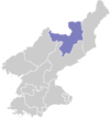
Kimhyonggwon County
Kim Hyŏng-gwŏn County
김형권군 | |
|---|---|
| Korean transcription(s) | |
| • Chosŏn'gŭl | 김형권군 |
| • Hancha | 金亨權郡 |
| • McCune-Reischauer | Kimhyŏnggwŏn-gun |
| • Revised Romanization | Gimhyeonggwon-gun |
 Map of Ryanggang showing the location of Kimhyonggwon | |
| Coordinates: 40°45′0″N 128°10′0″E / 40.75000°N 128.16667°E | |
| Country | North Korea |
| Province | Ryanggang |
| Administrative divisions | 1 ŭp, 1 workers' district, 17 ri |
| Area | |
| • Total | 1,243 km2 (480 sq mi) |
| Population (2008[1]) | |
| • Total | 37,528 |
| • Density | 30/km2 (78/sq mi) |
Kimhyŏnggwŏn County is a kun, or county, in southeastern Ryanggang province, North Korea. It borders South Hamgyŏng to the south. Previously known as Pungsan, it was renamed by Kim Il Sung in 1990. He named it after his uncle, Kim Hyŏng-gwŏn. It is known for its striking scenery and for the Pungsan Dog, a large breed of hunting dog.
Geography
[edit]Kimhyŏnggwŏn lies on the southeastern edge of the Kaema Plateau, and is covered with mountainous terrain. The Hamgyong Mountains and the Puksubaek Mountains both pass through the county. The highest peak is Paeksan. There are many streams; the chief among them is the Hŏch'ŏn River. Some 88% of the county's area is occupied by forestland.
Climate
[edit]| Climate data for Pungsan (1991–2020) | |||||||||||||
|---|---|---|---|---|---|---|---|---|---|---|---|---|---|
| Month | Jan | Feb | Mar | Apr | May | Jun | Jul | Aug | Sep | Oct | Nov | Dec | Year |
| Mean daily maximum °C (°F) | −6.2 (20.8) |
−2.8 (27.0) |
3.1 (37.6) |
11.0 (51.8) |
17.9 (64.2) |
21.6 (70.9) |
23.9 (75.0) |
23.5 (74.3) |
19.2 (66.6) |
13.0 (55.4) |
3.5 (38.3) |
−4.3 (24.3) |
10.3 (50.5) |
| Daily mean °C (°F) | −14.4 (6.1) |
−10.7 (12.7) |
−3.8 (25.2) |
3.9 (39.0) |
10.3 (50.5) |
14.6 (58.3) |
17.9 (64.2) |
17.4 (63.3) |
11.7 (53.1) |
4.6 (40.3) |
−4.0 (24.8) |
−11.9 (10.6) |
3.0 (37.4) |
| Mean daily minimum °C (°F) | −21.3 (−6.3) |
−17.8 (0.0) |
−10.7 (12.7) |
−3.0 (26.6) |
3.1 (37.6) |
8.3 (46.9) |
12.9 (55.2) |
12.6 (54.7) |
5.4 (41.7) |
−2.4 (27.7) |
−10.5 (13.1) |
−18.6 (−1.5) |
−3.5 (25.7) |
| Average precipitation mm (inches) | 6.4 (0.25) |
6.6 (0.26) |
13.4 (0.53) |
26.8 (1.06) |
49.2 (1.94) |
93.4 (3.68) |
157.2 (6.19) |
132.0 (5.20) |
64.5 (2.54) |
30.1 (1.19) |
20.7 (0.81) |
9.5 (0.37) |
609.8 (24.01) |
| Average precipitation days (≥ 0.1 mm) | 3.1 | 4.2 | 6.4 | 7.9 | 10.2 | 12.5 | 13.7 | 12.6 | 7.5 | 5.4 | 5.8 | 4.6 | 93.9 |
| Average snowy days | 5.1 | 5.7 | 8.8 | 6.7 | 1.1 | 0.0 | 0.0 | 0.0 | 0.0 | 1.9 | 6.5 | 6.3 | 42.1 |
| Average relative humidity (%) | 72.2 | 68.5 | 66.5 | 63.4 | 66.5 | 77.0 | 82.9 | 83.3 | 78.0 | 69.4 | 71.3 | 72.2 | 72.6 |
| Source: Korea Meteorological Administration[2] | |||||||||||||
Administrative divisions
[edit]Kimhyŏnggwŏn county is divided into 1 ŭp (town), 1 rodonjagu (workers' district) and 17 ri (villages):
|
|
Economy
[edit]There are several hydroelectric power stations in the county. There is also a great deal of dry-field farming; the chief local crops include hops and flax. In addition, potatoes, wheat, soybeans, and barley are grown, and livestock are also raised. In addition, there is some manufacturing and mining, with deposits of gold, nickel, graphite and iron sulfide found in the county.
Transportation
[edit]Kimhyŏnggwŏn is served by road, but not by rail.
See also
[edit]References
[edit]- ^ North Korea: Administrative Division
- ^ "30 years report of Meteorological Observations in North Korea (1991 ~ 2020)" (PDF) (in Korean). Korea Meteorological Administration. pp. 205, 279, and 343. Archived (PDF) from the original on 29 January 2022. Retrieved 23 March 2022.

