Saint-André-de-Kamouraska
Saint-André-de-Kamouraska | |
|---|---|
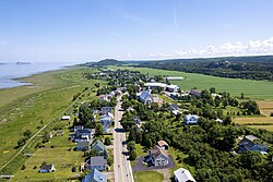
 Aerial view of Saint-André-de-Kamouraska | |
 Location within Kamouraska RCM | |
| Coordinates: 47°41′N 69°44′W / 47.683°N 69.733°W[1] | |
| Country | |
| Province | |
| Region | Bas-Saint-Laurent |
| RCM | Kamouraska |
| Constituted | February 14, 1987 |
| Government | |
| • Mayor | Gervais Darisse |
| • Federal riding | Montmagny—L'Islet—Kamouraska—Rivière-du-Loup |
| • Prov. riding | Côte-du-Sud |
| Area | |
| • Total | 70.60 km2 (27.26 sq mi) |
| • Land | 71.06 km2 (27.44 sq mi) |
| There is an apparent contradiction between two authoritative sources | |
| Population | |
| • Total | 658 |
| • Density | 9.3/km2 (24/sq mi) |
| • Pop 2016-2021 | |
| • Dwellings | 276 |
| Time zone | UTC−5 (EST) |
| • Summer (DST) | UTC−4 (EDT) |
| Postal code(s) | |
| Area code(s) | 418 and 581 |
| Highways | |
| Website | www.standre dekamouraska.ca |
Saint-André-de-Kamouraska is a municipality in the Canadian province of Quebec, located in the Kamouraska Regional County Municipality. Before 2020 it was only known as Saint-André.
History
[edit]The catholic parish of Saint-André de L'Islet-du-Portage, located at the height of the Pèlerins, a group of islands in the St. Lawrence River about 3 km offshore, was canonically erected in 1791. On the municipal level, the parish municipality of Saint-André and the village municipality of Andréville - detached from the parish municipality - came into being in 1855 and 1903 respectively, merging in 1987 to create the current municipality of Saint-André.
In 2020, the municipality of Saint-André changed its name to the current Saint-André-de-Kamouraska.
Geography
[edit]
Saint-André-de-Kamouraska is located on the southern shoreline of the Saint Lawrence River along with several islands belonging to the municipality situated offshore to the north.
Communities
[edit]The following locations reside within the municipality's boundaries:[1]
- Saint-André (47°40′33″N 69°43′29″W / 47.67583°N 69.72472°W)
- Saint-André-Station (47°37′49″N 69°41′09″W / 47.63028°N 69.68583°W) – a hamlet in the southeast part of the municipality
Lakes and rivers
[edit]The following waterways pass through or are situated within the municipality's boundaries:[1]
- Rivière des Caps (Mouth:47°43′21″N 69°40′35″W / 47.72250°N 69.67639°W)
- Rivière Fouquette (Mouth:47°42′04″N 69°42′09″W / 47.70111°N 69.70250°W)
Demographics
[edit]
|
| |||||||||||||||||||||||||||
| Source: Statistics Canada[4] | ||||||||||||||||||||||||||||
Government
[edit]- Mayor: Gervais Darisse
See also
[edit]- Saguenay–St. Lawrence Marine Park
- Île aux Lièvres (Saint Lawrence River)
- List of municipalities in Quebec
References
[edit]- ^ a b c "Banque de noms de lieux du Québec: Reference number 55585". toponymie.gouv.qc.ca (in French). Commission de toponymie du Québec.
- ^ a b "Répertoire des municipalités: Geographic code 14040". www.mamh.gouv.qc.ca (in French). Ministère des Affaires municipales et de l'Habitation.
- ^ a b https://www12.statcan.gc.ca/census-recensement/2021/dp-pd/prof/details/page.cfm?Lang=E&SearchText=Saint%2DAndr%C3%A9&GENDERlist=1&STATISTIClist=1,4&DGUIDlist=2021A00052414040&HEADERlist=0
- ^ 2006, 2011, 2016, 2021 census
External links
[edit] Media related to Saint-André-de-Kamouraska at Wikimedia Commons

