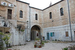
Beit David
Beit David
בית דוד | |
|---|---|
Neighborhood | |
 | |
 | |
| Coordinates: 31°46′59.08″N 35°13′11.35″E / 31.7830778°N 35.2198194°E | |
| Country | |
| City | West Jerusalem |
| Established | 1873 |
Beit David was the fourth Jewish neighborhood outside the walls of Jerusalem. This courtyard neighborhood was established in 1873.[1]
History
[edit]Beit David was founded as an almshouse for Jews on a plot of land donated by a kollel.[2] It was named for the philanthropist, David Reis. The name also alludes to the historical House of David and to the book known as Beit David, a treatise on Jewish law written by Joseph Ben David in the 18th century.[3] Because Beit David was far from the kollel's center in the Old City, it contained a synagogue and 10 apartments to ensure the existence of a minyan.[2]
The residence of Abraham Isaac Kook, Israel's first Askenanzic chief rabbi was on the second floor of the building, added in 1922. The Rabbi Kook House is now a museum of the life of Rabbi Kook.[4] The Museum of Psalms, located on the ground floor for many years, featured the paintings of Moshe Tzvi HaLevi Berger, a Kabbalist and painter. Berger was evicted in 2014 to make room for a yeshiva[5]
See also
[edit]References
[edit]- ^ Buzzy Gordon Frommer's Jerusalem Day by Day John Wiley & Sons, Oct 11, 2010 Google Books
- ^ a b Zvi Shilony (1993). "Ashkenazi Jewish Almshouses in Jerusalem". Journal of Cultural Geography. 14: 35–48. doi:10.1080/08873639309478379.
- ^ Eisenberg, Ronald L. The Streets of Jerusalem: Who, What, Why. Jerusalem: Devora, 2006. ISBN 9781932687545 WorldCat link as given in Google Books
- ^ Peeking through the highrises: famed Jerusalem street's old architectural glories, Haaretz
- ^ Museum of Psalms
