
Bretzfeld
You can help expand this article with text translated from the corresponding article in German. (February 2009) Click [show] for important translation instructions.
|
Bretzfeld | |
|---|---|
 Coat of arms | |
Location of Bretzfeld within Hohenlohekreis district  | |
 Bretzfeld  Bretzfeld | |
| Coordinates: 49°11′N 9°26′E / 49.183°N 9.433°E | |
| Country | Germany |
| State | Baden-Württemberg |
| Admin. region | Stuttgart |
| District | Hohenlohekreis |
| Subdivisions | 12 Ortsteile |
| Government | |
| • Mayor (2023–31) | Martin Piott[1] |
| Area | |
| • Total | 64.69 km2 (24.98 sq mi) |
| Elevation | 210 m (690 ft) |
| Population (2022-12-31)[2] | |
| • Total | 12,608 |
| • Density | 190/km2 (500/sq mi) |
| Time zone | UTC+01:00 (CET) |
| • Summer (DST) | UTC+02:00 (CEST) |
| Postal codes | 74626 |
| Dialling codes | 07946, 07945 |
| Vehicle registration | KÜN, ÖHR |
| Website | www.bretzfeld.de |
Bretzfeld is a municipality in the Hohenlohe district, in Baden-Württemberg, Germany. It is located 17 km (11 mi) east of Heilbronn. There is an exit (Nr. 39) with the same name at the A6 motorway.
Todays Bretzfeld is a sort of collective municipality or merger as the following 11 villages (Ortsteile), that each have their own history and previously were independent, were incorporated into the original village of Bretzfeld troughout 1972 and 1975: Adolzfurt, Bitzfeld, Brettach, Dimbach, Geddelsbach, Rappach, Scheppach, Schwabbach, Siebeneich, Unterheimbach, Waldbach

History
[edit]This section needs expansion. You can help by adding to it. (January 2024) |
In 1973, the districts of Heilbronn and Hohenlohe were established. All villages, except for Brettach, were included in the Hohenlohe district and were later merged into Bretzfeld in 1975. Brettach was part of the Heilbronn district until 1977 when it was also incorporated into Bretzfeld, which was already part of the Hohenlohe district.
Adolzfurt
[edit]| Year | Pop. | ±% |
|---|---|---|
| 1861 | 432 | — |
| 1987 | 203 | −53.0% |
| 31.12.1998 | 189 | −6.9% |
| 30.06.2024 | 176 | −6.9% |
Adolzfurt was first historically mentioned in 1327 as "Adelhardtsfurth". The name probably comes from the male name "Adelhard". In the 13th century it was under the rule of Weinsberg until it was given to the Princes of Hohenlohe in 1336. In the same year, it was granted full city rights by Louis IV, Holy Roman Emperor. However, it never attained great importance, and in a document from 1350 it is again referred to as a village. From 1806 to 1812 the village was administered by Neuenstein. In 1812, Adolzburg became part of the Oberamt of Öhringen, an administrative region of Württemberg, which later became the Öhringen district in 1938. Today it is the only village in Bretzfeld that has never been part of the Weinsberg Oberamt.[3]

Bitzfeld (and Weißlensburg)
[edit]This section needs expansion. You can help by adding to it. (January 2024) |

Weißlensburg
[edit]A legend and the name of the hamlet (the ending -burg) indicate that a castle once stood at its south-eastern end. Weißlensburg has been connected to Bitzfeld due to a law passed in 1837.[4]
Brettach
[edit]| Year | Pop. | ±% |
|---|---|---|
| 1686 | 250 - 300 | — |
| 1806 | 506 | — |
| 1987 | 914 | +80.6% |
| 31.12.1998 | 998 | +9.2% |
| 30.09.2023 | 991 | −0.7% |
| Source: [3] | ||
Originally documented as divided into Upper-Brettach and Lower-Brettach since 1376, the whole of Brettach is historically connected to the Maienfels Castle that is today in the eponymous village in Wüstenrot. Interestingly, the hamlets of Kreuzle und Busch, also part of Wüstenrot today, grew out of Brettach. Brettach was owned by the noble house of Weinsberg until they sold it to the Electoral Palatinate in 1423. Under Napoleon, the village became part of Württemberg in 1805. After that, Brettach was part of the following historical administrative divisions: Oberamt of Weinsberg (1809-1926), Oberamt of Öhringen (1926-1938), District of Öhringen (1938-1972), District of Heilbronn (1972-1977). It was incorporated into Bretzfeld on 1 January 1977, hence being the last village to join Bretzfeld.[5]
-
 The Maienfels Castle
 -
 Brettach, as seen from the castle
 -


.png)
Dimbach
[edit]| Year | Pop. | ±% |
|---|---|---|
| 1624 | 250 | — |
| 1798 | 337 | +34.8% |
| 1808 | 391 | +16.0% |
| 1987 | 611 | +56.3% |
| 31.12.1998 | 823 | +34.7% |
| 30.09.2023 | 887 | +7.8% |
| Source: [6] | ||
Dimbach was first mentioned in 1289 as "Tindebach". It was under the rule of Weinsberg until 1311. It was then under the administration of Lichtenstern Monastery until Würtemmberg took over the region shortly after the Reformation. The church in Dimbach was also built around this time.[6]
.png)
Gedelsbach
[edit]| Year | Pop. | ±% |
|---|---|---|
| 1680 | 150 | — |
| 1806 | 232 | +54.7% |
| 1987 | 194 | −16.4% |
| 31.12.1998 | 209 | +7.7% |
| 30.06.2024 | 280 | +34.0% |
First documented as Geydelsbach in 1337, it is uncertain whether the village belonged to the manor of either Heimberg or Maienfels. In the 15th century, the hamlet was owned by the Berlers, a family of Patricians, of which Heinrich Berler sold it to the noblemen of Hohenlohe in 1482. It stayed in their possession until it was taken by Württemberg in 1806. It was later part of the following historical administrative divisions: Oberamt of Öhringen (1809-12), Oberamt of Weinsberg (1812-26), Oberamt of Öhringen (1938-92), District of Öhringen (1972-1975). Gedelsbach joined the Hohenlohe district and was incorporated into Bretzfeld in 1975, by un-incorporating from Maienfels. Viticulture in Gedelsbach is attested since 1573, although it suffered under the Grape Phylloxera and was temporarily completely abolished in the 1960's. Today, predominantly white wine is grown, and the Geddelsbacher Schneckenhof has attained regional significance.[7]

Rappach
[edit]This section needs expansion. You can help by adding to it. (January 2024) |
| Year | Pop. | ±% |
|---|---|---|
| 1495 | 150 | — |
| 1769 | 263 | +75.3% |
| 1806 | 339 | +28.9% |
| 1961 | 385 | +13.6% |
| 1987 | 616 | +60.0% |
| 31.12.1998 | 1,357 | +120.3% |
| 30.06.2024 | 1,241 | −8.5% |
Rappach, first documented in 1215 as Rohbach, in 1253 as Rotbach and in 1277 as Rotpach, is known under its current form since the 16th century and is thought to have originated a lot earlier, in the ninth or tenth century. As most clearly recognizable in the 1253 version, the village was probably named after a red river or stream, as rot means red and Bach means River/Stream in German. The reason for the settlement might have been a castle that is said to have been located at the so-called Edelmannhof (lit. 'Nobleman's Court'), although no trace of the former has been found. Until 1450, Rappach is thought to have been under rule of the noblemen of Weinsberg, before it was taken by Electoral Palatinate and later by Württemberg in 1504.
The village underwent a major expansion at the beginning of the 1980s when the "Steinsfeld" (translatable to Rockfield) development area was established. Interestingly it was built were a former hamlet, Steinfurt (translatable to Rockford, like in Illinois) once stood.[8]
.png)
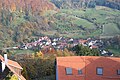
Scheppach
[edit]This section needs expansion. You can help by adding to it. (January 2024) |
.png)
Schwabbach
[edit]This section needs expansion. You can help by adding to it. (January 2024) |
.svg)
Siebeneich
[edit]This section needs expansion. You can help by adding to it. (January 2024) |
.png)
Unterheimbach
[edit]This section needs expansion. You can help by adding to it. (January 2024) |
Unterheimbach, first mentioned in 1300 as Heinebach, was taken by Württemberg in the early 19th century. It was previously ruled by various princes and noblemen, most notably the Lords of Heimberg. The ruins of the Heimberg Castle (today often erroneously called the Hellmath Ruin) bear witness to them. Viticulture, as it is attested since atleast 1537, still has major cultural and significance.[9]

Waldbach
[edit]| Year | Pop. | ±% |
|---|---|---|
| 1798 | 526 | — |
| 1809 | 607 | +15.4% |
| 1987 | 1,118 | +84.2% |
| 31.12.1998 | 1,445 | +29.2% |
| 30.06.2024 | 1,670 | +15.6% |
Waltbach, was first documented in 1264 and beloged to the Grafschaft of Löwenstein. After it was owned by the House of Habsburg for a short period of time, it was traded with the House of Hohenlohe for the village of Gerabronn in 1387. After it was taken by Württemberg, it was, like Dimberg, under administration of the Liechtenstern Monastery, after the reformation in 1534. It was later part of the following historical administrative divisions: District of Heilbronn (1806/7), Oberamt of Weinsberg (1807-?), Oberamt of Öhringen (?-1936), District of Öhringen (1938-1972). It was moved to the Hohenlohe District in 1972, where it was incorporated into Bretzfeld two years later. The village church is of cultural significance and local viticulture is attested since 1438 [10]
Waldbach is, after the main village Bretzfeld, the second biggest village of the Bretzfeld municipality.
.png)
Twin towns
[edit] Hungary: Budaörs (since 1989)
 Germany: Pretzfeld, (since 1978, because of the similair name and a Mail-Delivery accident therefore)[11]
References
[edit]- ^ Bürgermeisterwahl Bretzfeld 2023, Staatsanzeiger. Retrieved 13 June 2024.
- ^ "Bevölkerung nach Nationalität und Geschlecht am 31. Dezember 2022" [Population by nationality and sex as of December 31, 2022] (CSV) (in German). Statistisches Landesamt Baden-Württemberg. June 2023.
- ^ a b "Adolzfurt". Gemeinde Bretzfeld (in German). Retrieved 2024-01-27.
- ^ "Bitzfeld". Gemeinde Bretzfeld (in German). Retrieved 2024-08-16.
- ^ "Brettach". Gemeinde Bretzfeld (in German). Retrieved 2024-08-14.
- ^ a b "Dimbach". Gemeinde Bretzfeld (in German). Retrieved 2024-01-27.
- ^ "Geddelsbach". Gemeinde Bretzfeld (in German). Retrieved 2024-08-14.
- ^ "Rappach". Gemeinde Bretzfeld (in German). Retrieved 2024-08-16.
- ^ "Unterheimbach". Gemeinde Bretzfeld (in German). Retrieved 2024-08-16.
- ^ "Waldbach". Gemeinde Bretzfeld (in German). Retrieved 2024-08-14.
- ^ "Pretzfeld". Gemeinde Bretzfeld (in German). Retrieved 2024-08-14.
Towns and municipalities in Hohenlohe (district) | ||
|---|---|---|
| International | |
|---|---|
| National | |
| Geographic | |
This Hohenlohe district location article is a stub. You can help Wikipedia by expanding it. |