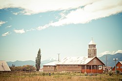
Contao, Chile
Appearance
Contao | |
|---|---|
 Church of Contao | |
 | |
| Coordinates: 41°48′9″S 72°43′7.32″W / 41.80250°S 72.7187000°W | |
| Region | Los Lagos |
| Province | Palena |
| Municipalidad | Hualaihué |
| Comuna | Hualaihué |
| Government | |
| • Type | Municipalidad |
| • Alcalde | Freddy Ibacache Muñoz |
| Elevation | 7 m (23 ft) |
| Population (2017 census [1]) | |
| • Total | 671 |
| Time zone | UTC−04:00 (Chilean Standard) |
| • Summer (DST) | UTC−03:00 (Chilean Daylight) |
| Area code | Country + town = 56 + 65 |
Contao is a village (Spanish: aldea) in the southeastern shore of Reloncaví Sound in southern Chile. It lies along the northernmost portion of Carretera Austral. It had 671 inhabitants as of 2017.[1] In colonial times Contao was a place of Fitzroya logging.
The village is served by Contao Airport.
References
[edit]- ^ "Ciudades, pueblos, aldeas y caceríos 2019" (PDF) (in Spanish). National Statistics Institute. 2019. Retrieved November 1, 2020.
