Crowdy Head
Appearance
| Crowdy Head New South Wales | |
|---|---|
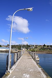
 Crowdy Head Jetty | |
| Population | 77 (2016 census)[1] |
| Postcode(s) | 2427 |
| LGA(s) | Mid-Coast Council |
| State electorate(s) | Port Macquarie |
| Federal division(s) | Lyne |
Crowdy Head is a headland on the coast of New South Wales, Australia, 7km from Harrington[2] between Forster and Port Macquarie. The head is mostly cleared and was quarried between 1895 and 1901 for the Manning River training wall.[3]
Crowdy Head is the site of Crowdy Head Light, a 24 feet (7.3 m) tall lighthouse built in 1878. And has a small harbour with a dedicated Marine Rescue NSW rescue boat, It is also home to Crowdy Head Surf Life Saving Club.[4]
References
[edit]- ^ Australian Bureau of Statistics (27 June 2017). "Crowdy Head (State Suburb)". 2016 Census QuickStats. Retrieved 4 February 2018.
- ^ "Crowdy Head". Geographical Names Register (GNR) of NSW. Geographical Names Board of New South Wales. Retrieved 1 August 2013.
- ^ Crowdy, Surf Life Saving Australia, retrieved 7 February 2014
- ^ Crowdy Head SLSC, retrieved 4 February 2014
Further reading
[edit]- "The Crowdy Head Lighthouse". Lighthouses of New South Wales. Lighthouses of Australia Inc. Retrieved 14 October 2009.
Wikimedia Commons has media related to Crowdy Head.
31°50.7′S 152°45.3′E / 31.8450°S 152.7550°E
