Fariman County
Appearance
Fariman County
Persian: شهرستان فریمان | |
|---|---|
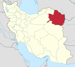
 Location of Fariman County in Razavi Khorasan Province (center right, yellow) | |
 Location of Razavi Khorasan Province in Iran | |
| Coordinates: 35°43′40″N 60°01′12″E / 35.72778°N 60.02000°E[1] | |
| Country | |
| Province | Razavi Khorasan |
| Capital | Fariman |
| Districts | Central, Qalandarabad |
| Area | |
• Total | 3,356 km2 (1,296 sq mi) |
| Population (2016)[2] | |
• Total | 99,001 |
| • Density | 29/km2 (76/sq mi) |
| Time zone | UTC+3:30 (IRST) |
| Fariman County at GEOnet Names Server | |
Fariman County (Persian: شهرستان فریمان) is in Razavi Khorasan Province, Iran. Its capital is the city of Fariman.[3]
Demographics
[edit]Population
[edit]At the time of the 2006 National Census, the county's population was 86,428 in 20,925 households.[4] The following census in 2011 counted 93,930 people in 25,686 households.[5] The 2016 census measured the population of the county as 99,001 in 28,641 households.[2]
Administrative divisions
[edit]Fariman County's population history and administrative structure over three consecutive censuses are shown in the following table.
| Administrative Divisions | 2006[4] | 2011[5] | 2016[2] |
|---|---|---|---|
| Central District | 63,694 | 70,169 | 73,640 |
| Balaband RD | 8,501 | 8,868 | 7,918 |
| Fariman RD | 9,351 | 10,220 | 10,738 |
| Sang Bast RD | 6,612 | 6,884 | 7,027 |
| Farhadgerd (city) | 6,620 | 7,647 | 8,442 |
| Fariman (city) | 32,610 | 36,550 | 39,515 |
| Qalandarabad District | 22,734 | 23,761 | 25,361 |
| Qalandarabad RD | 10,243 | 10,334 | 11,079 |
| Sefid Sang RD | 2,725 | 2,958 | 3,273 |
| Qalandarabad (city) | 4,872 | 4,924 | 4,880 |
| Sefid Sang (city) | 4,894 | 5,545 | 6,129 |
| Total | 86,428 | 93,930 | 99,001 |
| RD = Rural District | |||
See also
[edit]![]() Media related to Fariman County at Wikimedia Commons
Media related to Fariman County at Wikimedia Commons
References
[edit]- ^ OpenStreetMap contributors (30 October 2024). "Fariman County" (Map). OpenStreetMap (in Persian). Retrieved 30 October 2024.
- ^ a b c Census of the Islamic Republic of Iran, 1395 (2016): Razavi Khorasan Province. amar.org.ir (Report) (in Persian). The Statistical Center of Iran. Archived from the original (Excel) on 2 April 2022. Retrieved 19 December 2022.
- ^ Habibi, Hassan (1 December 2014) [Approved 2 August 1372]. "Creation and establishment of Fariman County with the center of Fariman city under the citizenship of Khorasan province". rc.majlis.ir (in Persian). Ministry of the Interior, Board of Ministers. Proposal 1.4.42.13398; Notification 2604/T26H. Archived from the original on 22 November 2015. Retrieved 8 January 2024 – via Islamic Parliament Research Center.
- ^ a b Census of the Islamic Republic of Iran, 1385 (2006): Razavi Khorasan Province. amar.org.ir (Report) (in Persian). The Statistical Center of Iran. Archived from the original (Excel) on 20 September 2011. Retrieved 25 September 2022.
- ^ a b Census of the Islamic Republic of Iran, 1390 (2011): Razavi Khorasan Province. irandataportal.syr.edu (Report) (in Persian). The Statistical Center of Iran. Archived from the original (Excel) on 20 January 2023. Retrieved 19 December 2022 – via Iran Data Portal, Syracuse University.

