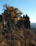
Großer Hermannsberg
| Großer Hermannsberg | |
|---|---|
 Südseite | |
| Highest point | |
| Elevation | 867 m (2,844 ft) |
| Prominence | 140 m ↓ 700 m SE of the summit (near the source of the Dörmbach) |
| Isolation | 2.5 km → Finsterbachkopf (898.3 m) – east of the Haselbach and the Kanzlersgrund |
| Coordinates | 50°42′3″N 10°36′52″E / 50.70083°N 10.61444°E |
| Geography | |
| Parent range | Thuringian Forest |
The Großer Hermannsberg is a mountain, 867 metres high, south of the main ridge of the Thuringian Forest in the county of Schmalkalden-Meiningen in Germany.
Location and area
[edit]To the north and immediately below the mountain is the village of Oberschönau and the adjacent Kanzlersgrund. Behind them is the main ridge of the Thuringian Forest with its long-distance trail, the Rennsteig. In front of the ridge are the mountains of Hohe Möst and Hoher Stein. To the southwest lies Bermbach, to the southeast is Zella-Mehlis and to the east is Oberhof.
Routes to the summit
[edit]- From Oberschönau or the Kanzlersgrund via the Oberschönau Hiking Hut (Ski- und Wanderhütte Oberschönau), past the plateau of the Kleiner Hermannsberg. From the Fuhrmannswiese pasture south of the mountain a path runs steeply uphill to the northern viewing rocks with their refuge hut. From this hut a path runs south to the main summit and its viewing rocks. As a return route a path can be taken from the Fuhrmannswiese on the north side of the mountain which returns to the hiker's hut.
- From the hiker's car park at the Knüllfeld the route heads for Ruppberg, before crossing the Fuhrmannswiese diagonally and continuing as above.
Summit description
[edit]
From the northern lookout rocks, the path runs along below the summit which, according to an inscription, is actually 873 metres high. From the path there is a further view of the Rhön mountains. Continuing towards the viewing rocks there is a view looking east by a small rock (see photograph below). The actual viewing rocks may be climbed using steps hewn out of the rock and a safety cable; the top is protected by railings. The top of these rocks is recorded on all the maps as being 867 metres high.
View
[edit]
- North
- Oberschönau (from the northern viewing rocks)
- East
- Donnershauk, Hohe Möst
- Kanzlersgrund
- Schanzenanlage Kanzlersgrund, Hoher Stein
- Gebrannter Stein
- Schneekopf
- Southeast
- Ringberghaus and Adlersberg Tower near Suhl
- From south to northwest
External links
[edit]- Annotated view from the Großer Hermannsberg looking south and west at www.panorama-photo.net

