Mirovice
Mirovice | |
|---|---|
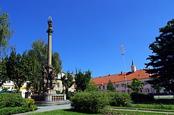
 Town square with the Marian column | |
| Coordinates: 49°30′56″N 14°2′9″E / 49.51556°N 14.03583°E | |
| Country | |
| Region | South Bohemian |
| District | Písek |
| First mentioned | 1323 |
| Area | |
• Total | 22.04 km2 (8.51 sq mi) |
| Elevation | 433 m (1,421 ft) |
| Population (2024-01-01)[1] | |
• Total | 1,653 |
| • Density | 75/km2 (190/sq mi) |
| Time zone | UTC+1 (CET) |
| • Summer (DST) | UTC+2 (CEST) |
| Postal code | 398 06 |
| Website | www |
Mirovice (Czech pronunciation: [ˈmɪrovɪtsɛ]) is a town in Písek District in the South Bohemian Region of the Czech Republic. It has about 1,700 inhabitants. The historic town centre is well preserved and is protected by law as an urban monument zone.
Administrative parts
[edit]The villages of Boješice, Kakovice, Ohař, Plíškovice, Ráztely, Řeteč, Sochovice and Touškov are administrative parts of Mirovice.
Etymology
[edit]The name is derived from the personal name Mír, meaning "the village of Mír's people".[2]
Geography
[edit]Mirovice is located about 24 kilometres (15 mi) north of Písek and 61 km (38 mi) southwest of Prague. It lies in the Benešov Uplands. The highest point is the flat hill Chlumek at 526 m (1,726 ft) above sea level. The Skalice River flows through the town.
History
[edit]The first written mention of Mirovice is from 1323. The oldest part of Mirovice is Ráztely, mentioned already in 1088.[3]
Demographics
[edit]
|
|
| ||||||||||||||||||||||||||||||||||||||||||||||||||||||
| Source: Censuses[4][5] | ||||||||||||||||||||||||||||||||||||||||||||||||||||||||
Transport
[edit]The I/19 road from Plzeň to Tábor passes through the town.
Mirovice is located on the major railway line Prague–České Budějovice.[6]
Sights
[edit]
The main landmark is the Church of Saint Clement. It was probably built around 1240. In 1726, it was rebuilt in the Baroque style according to the plans of Kilian Ignaz Dientzenhofer.[7]
The Marian column on the square is from 1717.[7]
Twin towns – sister cities
[edit] Bätterkinden, Switzerland
References
[edit]- ^ "Population of Municipalities – 1 January 2024". Czech Statistical Office. 2024-05-17.
- ^ Profous, Antonín (1951). Místní jména v Čechách III: M–Ř (in Czech). p. 94.
- ^ "Historie Mirovic – Datum první písemné zmínky" (in Czech). Město Mirovice. Retrieved 2021-08-27.
- ^ "Historický lexikon obcí České republiky 1869–2011" (in Czech). Czech Statistical Office. 2015-12-21.
- ^ "Population Census 2021: Population by sex". Public Database. Czech Statistical Office. 2021-03-27.
- ^ "Detail stanice Mirovice" (in Czech). České dráhy. Retrieved 2024-07-19.
- ^ a b "Mirovice – Památky" (in Czech). Město Mirovice. Retrieved 2021-08-27.
- ^ "Bätterkinden - partnerská obec" (in Czech). Město Mirovice. Retrieved 2021-08-27.


