Nanjiang County
Appearance
Nanjiang County
南江县 Nankiang | |
|---|---|
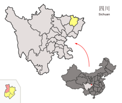
 Location of Nanjiang County (red) within Bazhong City (yellow) and Sichuan | |
| Country | China |
| Province | Sichuan |
| Prefecture-level city | Bazhong |
| Area | |
• Total | 3,388 km2 (1,308 sq mi) |
| Population (2020) | |
• Total | 467,609 |
| • Density | 140/km2 (360/sq mi) |
| Time zone | UTC+8 (China Standard) |
Nanjiang County (Chinese: 南江县; pinyin: Nánjiāng Xiàn) is a county in the northeast of Sichuan Province, China, bordering Shaanxi province to the north. It is under the administration of Bazhong city.
Administrative divisions
[edit]Nanjiang County comprises 1 subdistrict, 29 towns and 2 townships:[1]
- subdistricts
- Jizhou 集州街道
- towns
- Shahe 沙河镇
- Changchi 长赤镇
- Zhengzhi 正直镇
- Dahe 大河镇
- Guangwushan 光雾山镇
- Xialiang 下两镇
- Ganchang 赶场镇
- Yangba 杨坝镇
- Tianchi 天池镇
- Guanba 关坝镇
- Hongguang 红光镇
- Yuantan 元潭镇
- Chixi 赤溪镇
- Bamiao 八庙镇
- Shuangliu 双流镇
- Pinghe 坪河镇
- Qiaoting 桥亭镇
- Heping 和平镇
- Houjia 侯家镇
- Renhe 仁和镇
- Gaota 高塔镇
- Xingma 兴马镇
- Guanmen 关门镇
- Shitan 石滩镇
- Gaoqiao 高桥镇
- Guimin 贵民镇
- Guanlu 关路镇
- Yunding 云顶镇
- Gongshan 公山镇
- townships
- Tuanjie 团结乡
- Shenmen 神门乡
Climate
[edit]| Climate data for Nanjiang, elevation 579 m (1,900 ft), (1991–2020 normals, extremes 1981–2010) | |||||||||||||
|---|---|---|---|---|---|---|---|---|---|---|---|---|---|
| Month | Jan | Feb | Mar | Apr | May | Jun | Jul | Aug | Sep | Oct | Nov | Dec | Year |
| Record high °C (°F) | 19.3 (66.7) |
23.2 (73.8) |
31.9 (89.4) |
33.9 (93.0) |
38.4 (101.1) |
37.4 (99.3) |
40.2 (104.4) |
40.3 (104.5) |
37.7 (99.9) |
31.1 (88.0) |
26.2 (79.2) |
19.4 (66.9) |
40.3 (104.5) |
| Mean daily maximum °C (°F) | 9.6 (49.3) |
12.4 (54.3) |
17.6 (63.7) |
23.3 (73.9) |
27.0 (80.6) |
29.7 (85.5) |
31.8 (89.2) |
32.0 (89.6) |
26.3 (79.3) |
21.1 (70.0) |
15.9 (60.6) |
10.6 (51.1) |
21.4 (70.6) |
| Daily mean °C (°F) | 5.2 (41.4) |
7.7 (45.9) |
12.0 (53.6) |
17.0 (62.6) |
20.8 (69.4) |
23.9 (75.0) |
26.1 (79.0) |
25.8 (78.4) |
21.3 (70.3) |
16.3 (61.3) |
11.3 (52.3) |
6.4 (43.5) |
16.2 (61.1) |
| Mean daily minimum °C (°F) | 2.2 (36.0) |
4.5 (40.1) |
8.0 (46.4) |
12.5 (54.5) |
16.3 (61.3) |
19.8 (67.6) |
22.2 (72.0) |
21.8 (71.2) |
18.1 (64.6) |
13.4 (56.1) |
8.3 (46.9) |
3.6 (38.5) |
12.6 (54.6) |
| Record low °C (°F) | −4.8 (23.4) |
−2.3 (27.9) |
−2.8 (27.0) |
2.1 (35.8) |
8.0 (46.4) |
12.5 (54.5) |
15.5 (59.9) |
13.3 (55.9) |
11.0 (51.8) |
−0.3 (31.5) |
−1.6 (29.1) |
−6.1 (21.0) |
−6.1 (21.0) |
| Average precipitation mm (inches) | 6.3 (0.25) |
12.7 (0.50) |
27.9 (1.10) |
64.7 (2.55) |
121.2 (4.77) |
173.9 (6.85) |
271.3 (10.68) |
181.0 (7.13) |
198.6 (7.82) |
87.6 (3.45) |
39.5 (1.56) |
8.3 (0.33) |
1,193 (46.99) |
| Average precipitation days (≥ 0.1 mm) | 6.1 | 6.7 | 8.7 | 11.4 | 13.3 | 13.1 | 15.7 | 13.6 | 13.8 | 13.5 | 8.8 | 6.2 | 130.9 |
| Average snowy days | 2.3 | 1.1 | 0.2 | 0 | 0 | 0 | 0 | 0 | 0 | 0 | 0.1 | 0.6 | 4.3 |
| Average relative humidity (%) | 72 | 70 | 66 | 68 | 69 | 74 | 78 | 75 | 80 | 80 | 78 | 75 | 74 |
| Mean monthly sunshine hours | 80.7 | 75.0 | 117.6 | 155.3 | 172.6 | 165.9 | 194.2 | 204.1 | 122.5 | 106.6 | 92.7 | 81.8 | 1,569 |
| Percent possible sunshine | 25 | 24 | 31 | 40 | 40 | 39 | 45 | 50 | 33 | 31 | 30 | 26 | 35 |
| Source: China Meteorological Administration[2][3] | |||||||||||||
References
[edit]- ^ 2023年统计用区划代码和城乡划分代码:南江县 (in Simplified Chinese). National Bureau of Statistics of China.
- ^ 中国气象数据网 – WeatherBk Data (in Simplified Chinese). China Meteorological Administration. Retrieved 14 April 2023.
- ^ 中国气象数据网 (in Simplified Chinese). China Meteorological Administration. Retrieved 14 April 2023.
