Nir Akiva
Appearance
Nir Akiva
ניר עקיבא نير عكيفا | |
|---|---|
 Village synagogue | |
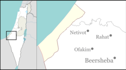
| Coordinates: 31°28′12″N 34°38′48″E / 31.47000°N 34.64667°E | |
| Country | Israel |
| District | Southern |
| Council | Merhavim |
| Affiliation | Moshavim Movement |
| Founded | 1953 |
| Population (2022)[1] | 714 |
Nir Akiva (Hebrew: נִיר עֲקִיבָא, lit. Akiva's Meadow) is a moshav in southern Israel. Located in the north-western Negev near Netivot and Nir Moshe and covering 1,000 dunams, it falls under the jurisdiction of Merhavim Regional Council. In 2022 it had a population of 714.[1]
History
[edit]The moshav was established in 1953 on land that had belonged to the Palestinian village of Kawfakha.[2] It was named after Akiva Etinger, a chief of the Settlement Department in the Jewish Agency. In the late 1970s Amir Peretz was a member of the moshav, bought a farm in the village and grew vegetables and flowers for export.
References
[edit]- ^ a b "Regional Statistics". Israel Central Bureau of Statistics. Retrieved 21 March 2024.
- ^ Khalidi, Walid (1992). All That Remains: The Palestinian Villages Occupied and Depopulated by Israel in 1948. Washington D.C.: Institute for Palestine Studies. pp. 119–121. ISBN 0-88728-224-5. Population 1944/45 500
External links
[edit]- Nir Akiva Negev Information Centre

