Portal:Bolivia
| Portal | WikiProject | Peer Review | Assessment | Task Force |
IntroductionWelcome to the Bolivia portal
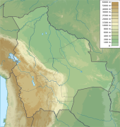
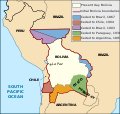
  Bolivia, officially the Plurinational State of Bolivia, is a landlocked country located in western-central South America. It is bordered by Brazil to the north and east, Paraguay to the southeast, Argentina to the south, Chile to the southwest, and Peru to the west. The seat of government and administrative capital is La Paz, which contains the executive, legislative, and electoral branches of government, while the constitutional capital is Sucre, the seat of the judiciary. The largest city and principal industrial center is Santa Cruz de la Sierra, located on the Llanos Orientales (eastern tropical lowlands), a mostly flat region in the east of the country. The sovereign state of Bolivia is a constitutionally unitary state divided into nine departments. Its geography varies as the elevation fluctuates, from the western snow-capped peaks of the Andes to the eastern lowlands, situated within the Amazon basin. One-third of the country is within the Andean mountain range. With an area of 1,098,581 km2 (424,164 sq mi), Bolivia is the fifth-largest country in South America after Brazil, Argentina, Peru and Colombia, and, alongside Paraguay, is one of two landlocked countries in the Americas. It is the 27th largest country in the world, the largest landlocked country in the Southern Hemisphere, and the seventh largest landlocked country on earth, after Kazakhstan, Mongolia, Chad, Niger, Mali, and Ethiopia. Bolivia experienced a succession of military and civilian governments until Hugo Banzer led a CIA-supported coup d'état in 1971, replacing the socialist government of Juan José Torres with a military dictatorship. Banzer's regime cracked-down on left-wing and socialist opposition parties, and other perceived forms of dissent, resulting in the torturing and murders of countless Bolivian citizens. Banzer was ousted in 1978 and, twenty years later, returned as the democratically elected President of Bolivia (1997–2001). Under the 2006–2019 presidency of Evo Morales, the country saw significant economic growth and political stability, but was also widely accused of democratic backsliding and was described as a competitive authoritarian regime. Freedom House classifies Bolivia as a partly-free democracy as of 2023, with a 66/100 score. (Full article...) Selected article -El Alto International Airport (Spanish: Aeropuerto Internacional El Alto) (IATA: LPB, ICAO: SLLP) is an international airport serving La Paz, Bolivia. It is located in the city of El Alto, 13 kilometres (8 mi) west of La Paz. At an elevation of 4,061.5 metres (13,325 ft), it is the highest international airport in the world, the seventh highest commercial airport in the world and the highest commercial airport outside of China. The airport has been in service since the first half of the 20th century, but was modernized in the late 1960s, when its runway was lengthened and a new passenger terminal with modern facilities was built. The new airport was inaugurated in 1965. El Alto airport was a primary hub for the former Lloyd Aéreo Boliviano, Bolivia's flag carrier which ceased operations in 2007 and is a hub for Línea Aérea Amaszonas. It serves also as a focus city for Boliviana de Aviación, Bolivia's flag carrier and state-owned airline. (Full article...)Did you know (auto-generated)
Selected pictureTopicsLargest populated areas
Related portals
WikiProjectsAssociated WikimediaDiscover Wikipedia using portals New ArticlesThis list was generated from these rules. Questions and feedback are always welcome! The search is being run daily with the most recent ~14 days of results. Note: Some articles may not be relevant to this project.
Rules | Match log | Results page (for watching) | Last updated: 2024-07-02 19:40 (UTC) Note: The list display can now be customized by each user. See List display personalization for details.
| |||||||||||||||||||||||||||||||||||||||||||||||||||||||||||||||||||||||||||||||||||||||||||||||||||||||||||||||||||||||||||||||||||||||||||||||||||||


