Qingtian County
Qingtian
青田县 Tsingtien | |
|---|---|
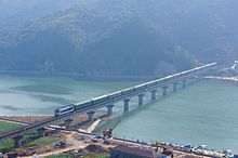
 Hecheng (seat of Qingtian), from the south-east, 2023 | |
| Nickname: Little Europe (小欧洲) | |
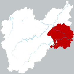
 Location of Qingtian County within Lishui | |
| Coordinates: 28°8′3″N 120°17′27″E / 28.13417°N 120.29083°E 28°07′23″N 120°16′59″E / 28.123°N 120.283°E | |
| Country | People's Republic of China |
| Province | Zhejiang |
| Prefecture-level city | Lishui |
| Area | |
• County | 2,493 km2 (963 sq mi) |
| Population (2022) | |
• County | 568,800 |
| • Urban | 168,500 |
| Demonym | Qingtianese |
| Time zone | UTC+8 (China Standard) |
| Postal code | 323900 |
| Area code | 0578 |
| Website | https://www.qingtian.gov.cn/ |
Qingtian (Chinese: 青田; pinyin: Qīngtián; Wade–Giles: Ch'ing-t'ien; lit. 'azure field'), is a county located in the southeastern part of Lishui, Zhejiang, China. It is split in two by the Ou River, which flows 388 kilometers before finally reaching the city of Wenzhou and emptying into the East China Sea. The county has a recorded history since 711 AD, and its name originates from its rich rice paddy fields. It has subtropical monsoon climate, with an annual average temperature of 18.3 °C (64.9 °F), and an annual rainfall of 1,747 mm (68.8 in). It has a hilly territory with many ravines. Its capital is Hecheng, also known as Qingtian City. The majority of inhabitants speak Qingtianese, while a small minority of residents in Wenxi town (温溪镇) speak Wenzhounese, both of which belong to the larger Wu language family. The county is particularly famous in China for its diasporan communities spread all across the globe, forming the bulk of Chinese populations in many European states, especially in Spain where they constitute over 80% of the entire Chinese community. The area is also well known by its traditional stonecarving industry, that has been defined as "embroidery on stone" since the Northern and Southern dynasties period at least.[1][2]
History
[edit]Early history
[edit]Tang dynasty
[edit]Qingtian county was officially established in the 2nd year of Jingyun (711) as a part of the Kuozhou prefecture (aliase of present-day Lishui).[3] The etymology of its name derives from a grass with bamboo-like leaves that can be turned into cyan-colored dyes, which is abundant in the paddy fields at the foot of the mountain in the county's northern corner.[4]
Song dynasty
[edit]In 1197 (3nd year of Qingyuan, Southern Song), in a major reconstruction project initiated by the local notable Zheng Ruxie (郑汝谐), all the shabby thatched cottages in the county town were replaced with houses built of ceramic tiles, significantly improving the county's sanitary conditions whilst reducing the risk of fire.[5]
Ming dynasty
[edit]In the 35th year of Emperor Jiajing of Ming (1556), due to the constant attacks by Wokous coming from the coastal areas, the county magistrate Li Kai (李楷)ordered the construction of a 3 kilometers long stone wall surrounding the town, the section of wall along the Ou River still remains today,[6] and Qingtian is henceforth the only county in Lishui to have its own walled fortifications.[7]
In April, 1558, another assault on the town by Wokous was successfully repelled due to the protection by the wall.[8]

Modern history
[edit]In the early years of the Republic of China, almost the entire county was devastated by the flood brought by a heavy rainstorm on August 29, 1912. Record says that the flood had affected as many as 16,133 households and destroyed 76,623 buildings,[9] and only 5000 people were left in Hecheng which had at once boasted more than 14,000 residents. Extreme hardship in the aftermath of the floods pushed many to emigrate abroad, which between 1912 and 1914, approximately a thousand people had left the county,[10] and around two thousand Qingtianese were among the 140,000 Chinese Labour Corps that served on the Western Front, following China's entry into the World War I on the side of Entente Powers in 1917.[citation needed]
Owing to its scarce arable lands and its vibrant overseas communities that brought ideas and news from the Western world, Qingtian was the earliest region where the Chinese Communist Party began its activities in southwestern Zhejiang.[citation needed]
As part of Zhejiang's provincial road network, a gravel road with a total length of 124.08 km that ran from Lishui to Wenzhou via Qingtian was completed and opened to traffic in 1934.[11]

In 1948, to deal with the increasing Communist guerrilla activities and banditry in the climax of Chinese Civil War, Nantian township (南田乡), also known as the birthplace of Liu Bowen, was separated from Qingtian and incorporated into the newly established county of Wencheng (文成县); as a compensation, the town of Wenxi from the neighboring Yongjia county (永嘉县) was added into Qingtian, giving the county access to its inland port facility.[12]
The Nationalist rule in Qingtian ended with the arrival of the People's Liberation Army on May 13, 1949, and the People's Government of Qingtian was officially established in November 4 the same year.[13]
Waves of intense political violence occurred in Qingtian during the early phase of Cultural Revolution as part of the nationwide violent struggles.[14]
The Jinhua-Wenzhou railway that runs through Qingtian, as the first railway with investment from a joint venture, between Chinese state-owned enterprise and privately held companies in the infrastructural history of China was opened on June 11, 1998.[citation needed]
Administrative divisions
[edit]The county of Qingtian is divided into 4 subdistricts, 10 towns, 18 townships, and 363 villages, with a total area of 2493 km2[15]
Subdistricts:
Towns:[16]
- Wenxi (温溪镇), Dongyuan (东源镇), Chuanliao (船寮镇), Beishan (北山镇), Shankou (山口镇), Haikou (海口镇), Gaohu (高湖镇), Lakou (腊口镇), Renzhuang (仁庄镇)
Townships:
- Zhangcun (章村乡), Shuqiao (舒桥乡), Gui'ao (贵岙乡), Shixi (石溪乡), Zhenbu (祯埠乡), Zhenwang (祯旺乡), Wanshan (万山乡), Huangyang (黄垟乡), Jizhai (季宅乡), Haixi (海溪乡), Gaoshi (高市乡), Jupu (巨浦乡), Wanfu (万阜乡), Tangyang (汤垟乡), Fangshan (方山乡), Wukeng (吴坑乡), Renguan (仁宫乡), Zhangdan (章旦乡), Fushan (阜山乡), Linggen (岭根乡), Xiaozhoushan (小舟山乡)
Population
[edit]| Year[17][18] | Population |
|---|---|
| 742 | ~36,000 |
| 1551 | 41,567 |
| 1776 | 89,667 |
| 1911 | 219,206 |
| 1942 | 271,073 |
| 1946 | 257,657 |
| 1949 | 227,800 |
| 2000 | 361,062 |
| 2010 | 336,542 |
| 2020 | 509,053 |
Climate
[edit]| Climate data for Qingtian (1991–2020 normals, extremes 1981–2010) | |||||||||||||
|---|---|---|---|---|---|---|---|---|---|---|---|---|---|
| Month | Jan | Feb | Mar | Apr | May | Jun | Jul | Aug | Sep | Oct | Nov | Dec | Year |
| Record high °C (°F) | 26.7 (80.1) |
30.6 (87.1) |
32.5 (90.5) |
35.3 (95.5) |
39.3 (102.7) |
39.4 (102.9) |
41.9 (107.4) |
40.6 (105.1) |
40.1 (104.2) |
36.7 (98.1) |
31.7 (89.1) |
26.4 (79.5) |
41.9 (107.4) |
| Mean daily maximum °C (°F) | 12.8 (55.0) |
14.9 (58.8) |
18.2 (64.8) |
23.6 (74.5) |
27.7 (81.9) |
30.5 (86.9) |
34.4 (93.9) |
33.9 (93.0) |
30.3 (86.5) |
26.0 (78.8) |
20.7 (69.3) |
15.3 (59.5) |
24.0 (75.2) |
| Daily mean °C (°F) | 8.3 (46.9) |
9.9 (49.8) |
13.0 (55.4) |
18.1 (64.6) |
22.5 (72.5) |
25.7 (78.3) |
29.0 (84.2) |
28.6 (83.5) |
25.6 (78.1) |
20.9 (69.6) |
15.8 (60.4) |
10.3 (50.5) |
19.0 (66.2) |
| Mean daily minimum °C (°F) | 5.3 (41.5) |
6.6 (43.9) |
9.6 (49.3) |
14.3 (57.7) |
19.0 (66.2) |
22.6 (72.7) |
25.4 (77.7) |
25.2 (77.4) |
22.3 (72.1) |
17.3 (63.1) |
12.5 (54.5) |
6.9 (44.4) |
15.6 (60.0) |
| Record low °C (°F) | −3.7 (25.3) |
−3.7 (25.3) |
−2.7 (27.1) |
3.4 (38.1) |
10.2 (50.4) |
13.3 (55.9) |
19.1 (66.4) |
19.9 (67.8) |
14.1 (57.4) |
6.5 (43.7) |
0.6 (33.1) |
−4.1 (24.6) |
−4.1 (24.6) |
| Average precipitation mm (inches) | 56.9 (2.24) |
76.2 (3.00) |
142.5 (5.61) |
142.4 (5.61) |
167.7 (6.60) |
283.7 (11.17) |
207.2 (8.16) |
266.4 (10.49) |
185.8 (7.31) |
81.6 (3.21) |
65.8 (2.59) |
53.6 (2.11) |
1,729.8 (68.1) |
| Average precipitation days (≥ 0.1 mm) | 11.8 | 12.4 | 16.6 | 16.2 | 17.0 | 19.0 | 14.5 | 16.5 | 12.9 | 7.9 | 9.9 | 9.3 | 164 |
| Average snowy days | 1.5 | 1.4 | 0.2 | 0 | 0 | 0 | 0 | 0 | 0 | 0 | 0 | 0.6 | 3.7 |
| Average relative humidity (%) | 71 | 73 | 74 | 74 | 76 | 80 | 76 | 76 | 75 | 71 | 74 | 70 | 74 |
| Mean monthly sunshine hours | 97.2 | 97.1 | 107.4 | 128.7 | 132.7 | 116.8 | 203.4 | 189.5 | 152.3 | 156.7 | 115.1 | 118.6 | 1,615.5 |
| Percent possible sunshine | 30 | 31 | 29 | 33 | 32 | 28 | 48 | 47 | 42 | 44 | 36 | 37 | 36 |
| Source: China Meteorological Administration[19][20] | |||||||||||||
Transportation
[edit]- Highway:
By the end of 2013, the highway mileage in Qingtian county was 2,155.8 kilometers, including 67.3 kilometers of expressways, 145.7 kilometers of secondary roads, 16.8 kilometers of tertiary roads, 483.8 kilometers of quasi-fourth-class roads, and 1,442.2 kilometers of quasi-fourth-class roads. In 2013, the social passenger volume was 11.3 million, the freight volume was 4.53 million tons, the freight turnover was 717.49 million tons-kilometers, and the passenger turnover was 356.43 million person-kilometers. National Highway 330 passes through the county.
- Railway:

Qingtian is served by the Jinhua–Wenzhou high-speed railway.
- Waterway:
The Port of Wenxi is the only port in Lishui prefecture that has direct access to the outer sea, with an annual cargo throughput of more than 1.4 million tons. Cargo ships departing from the Port of Wenxi can directly reach major ports in mainland China, Hong Kong and Macau.
Notable people
[edit]- Chen Cheng, National Revolutionary Army commander, Vice President and Premier of Taiwan
- Chen Li-an, electrical engineer, mathematician and Taiwanese politician
- Chen Muhua, Communist revolutionary and People's Republic of China politician
- Xia Chao, civil governor of Zhejiang 1924–1926
- Zhang Naiqi, People's Republic of China politician
- Shifuku Oh (Wang Shifu), chef, father of Japanese baseball player Sadaharu Oh
See also
[edit]References
[edit]- ^ ""Embroidery on stone": Qingtian stone carving in east China". Xinhuanet. 21 November 2020. Retrieved 1 June 2021.
- ^ "Qingtian Stone Carving". chinaculture.org. Retrieved 1 June 2021.
- ^ "青田十大历史事件 十大历史人物评选结果公示". 2011-07-04.
- ^ "青田概况".
- ^ "九百年前的他,主持了一场"旧城改造"". tidenews.com.cn. Retrieved 2024-09-27.
- ^ 网易 (2022-12-21). "形制独特的青田古城". www.163.com. Retrieved 2024-09-27.
- ^ "青田城墙"半条城"_浙江扬眉吐气_新浪博客". blog.sina.com.cn. Retrieved 2024-09-27.
- ^ 网易 (2022-12-21). "形制独特的青田古城". www.163.com. Retrieved 2024-09-27.
- ^ "青田十大历史事件 十大历史人物评选结果公示". 2011-07-04.
- ^ "青田2000华工奔赴一战欧洲战场". lssz.lishui.gov.cn. Retrieved 2024-09-27.
- ^ 网易 (2020-12-30). "温州到杭州何时开始通上公路?80多年前坐汽车还是"奢侈品"". www.163.com. Retrieved 2024-09-28.
- ^ 网易 (2020-09-01). "文成县的"前世今生",和青田县息息相关!". www.163.com. Retrieved 2024-10-23.
- ^ 腾讯网 (2024-05-13). "75年前的今天,青田宣告解放!_腾讯新闻". news.qq.com (in Chinese (China)). Retrieved 2024-10-23.
- ^ banned-historical-archives.github.io https://banned-historical-archives.github.io/articles/f2860f6d17. Retrieved 2024-10-23.
{{cite web}}: Missing or empty|title=(help) - ^ "行政区划". 26 March 2024.
- ^ "丽水市-行政区划网 www.xzqh.org" (in Chinese). XZQH. Retrieved 2012-05-24.
- ^ "2024年[丽水]青田县人口总人口数口 户籍常住普查人口数据-红黑人口库". www.hongheiku.com. Retrieved 2024-10-23.
- ^ 陈, 慕榕 (October 1990). 青田县志 (第一版 ed.). 杭州武林路125号: 浙江人民出版社. p. 155.
{{cite book}}: CS1 maint: location (link) CS1 maint: year (link) - ^ 中国气象数据网 – WeatherBk Data (in Simplified Chinese). China Meteorological Administration. Retrieved 25 June 2023.
- ^ "Experience Template" 中国气象数据网 (in Simplified Chinese). China Meteorological Administration. Retrieved 25 June 2023.

