Sarvabad County
Appearance
Sarvabad County
Persian: شهرستان سروآباد | |
|---|---|
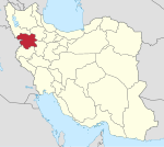
 Location of Sarvabad County in Kurdistan province (center left, pink) | |
 Location of Kurdistan province in Iran | |
| Coordinates: 35°13′N 46°23′E / 35.217°N 46.383°E[1] | |
| Country | Iran |
| Province | Kurdistan |
| Capital | Sarvabad |
| Districts | Central, Uraman |
| Population (2016)[2] | |
• Total | 44,940 |
| Time zone | UTC+3:30 (IRST) |
| Sarvabad County can be found at GEOnet Names Server, at this link, by opening the Advanced Search box, entering "9206627" in the "Unique Feature Id" form, and clicking on "Search Database". | |
Sarvabad County (Persian: شهرستان سروآباد) is in Kurdistan province, Iran. Its capital is the city of Sarvabad.[3]
History
[edit]After the 2011 National Census, the village of Uraman Takht was elevated to the status of a city.[4]
Demographics
[edit]Population
[edit]At the time of the 2006 census, the county's population was 53,992 in 12,641 households.[5] The following census in 2011 counted 49,841 people in 13,550 households.[6] The 2016 census measured the population of the county as 44,940 in 13,475 households.[2]
Administrative divisions
[edit]Sarvabad County's population history and administrative structure over three consecutive censuses are shown in the following table.
| Administrative Divisions | 2006[5] | 2011[6] | 2016[2] |
|---|---|---|---|
| Central District | 43,492 | 40,298 | 36,374 |
| Bisaran RD | 5,251 | 4,328 | 3,832 |
| Dezli RD | 4,914 | 5,185 | 5,377 |
| Kusalan RD | 10,022 | 9,183 | 8,244 |
| Paygelan RD | 6,975 | 5,989 | 4,769 |
| Razab RD | 7,243 | 6,715 | 6,065 |
| Zherizhah RD | 5,380 | 3,922 | 2,966 |
| Sarvabad (city) | 3,707 | 4,976 | 5,121 |
| Uraman District | 10,500 | 9,543 | 8,566 |
| Shalyar RD | 5,574 | 4,729 | 4,056 |
| Uraman Takht RD | 4,926 | 4,814 | 1,334 |
| Uraman Takht (city) | 3,176 | ||
| Total | 53,992 | 49,841 | 44,940 |
| RD = Rural District | |||
See also
[edit]![]() Media related to Sarvabad County at Wikimedia Commons
Media related to Sarvabad County at Wikimedia Commons
References
[edit]- ^ OpenStreetMap contributors (21 August 2023). "Sarvabad County" (Map). OpenStreetMap (in Persian). Retrieved 21 August 2023.
- ^ a b c "Census of the Islamic Republic of Iran, 1395 (2016)". AMAR (in Persian). The Statistical Center of Iran. p. 12. Archived from the original (Excel) on 8 May 2022. Retrieved 19 December 2022.
- ^ Aref, Mohammad Reza (27 November 1381). "Approval of divisional reforms in Sarvabad County". Lamtakam (in Persian). Ministry of Interior, Ministers of the Political-Defense Commission of the Government Council. Archived from the original on 22 January 2024. Retrieved 22 January 2024.
- ^ Rahimi, Mohammad Reza (14 January 2013). "Approval letter regarding the transformation of Uraman Takht village, the center of Uraman District of Sarvabad County in Kurdistan province, into a city". Lamtakam (in Persian). Ministry of Interior, Political and Defense Commission. Archived from the original on 22 January 2024. Retrieved 22 January 2024.
- ^ a b "Census of the Islamic Republic of Iran, 1385 (2006)". AMAR (in Persian). The Statistical Center of Iran. p. 12. Archived from the original (Excel) on 20 September 2011. Retrieved 25 September 2022.
- ^ a b "Census of the Islamic Republic of Iran, 1390 (2011)". Syracuse University (in Persian). The Statistical Center of Iran. p. 12. Archived from the original (Excel) on 19 January 2023. Retrieved 19 December 2022.

