Tanzi District
Appearance
Tanzi
潭子區 Tanzih | |
|---|---|
| Tanzi District | |
 | |
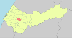
 Tanzi District in Taichung City | |
| Coordinates: 24°13′05″N 120°42′22″E / 24.218°N 120.706°E | |
| Country | Taiwan |
| Special municipality | Taichung |
| Established (District) | 2010 |
| Area | |
• Total | 25.8497 km2 (9.9806 sq mi) |
| Population (February 2023) | |
• Total | 108,761 |
| • Density | 4,200/km2 (11,000/sq mi) |
| Time zone | UTC+8 (CST) |
| Website | www |
Tanzi District (Chinese: 潭子區) is a suburban district with a population 108,761 as of February 2023, located north of Taichung, Taiwan. It has an area of 25.8497 km2.
Administrative divisions
[edit]Tanxiu, Tanbei, Tanyang, Furen, Toujia, Toujiatung, Jiaxing, Jiafu, Ganzhe, Tungbao, Dafu, Dafeng, Lilin, Jiaren, Xintian and Juxing Village.[1]
Economy
[edit]Taichung Tanzi Export Processing Zone is located in the township, providing a variety of employment opportunities.
Hospital
[edit]Created by Tzu Chi in 2007.
Native products
[edit]Education
[edit]- Tanzi Elementary School
- Haiwen Middle School
- Ivy Collegiate Academy
- Sintian Mountain
- Hongwen High School
Tourist attractions
[edit]Transportation
[edit]
References
[edit]Wikimedia Commons has media related to Tanzi District, Taichung.
- ^ "2014 Local Elections". Archived from the original on 2014-12-27. Retrieved 2014-12-27.

