Tyhee, Idaho
Appearance
Tyhee, Idaho | |
|---|---|
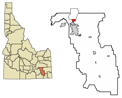
 Location of Tyhee in Bannock County, Idaho. | |
| Coordinates: 42°57′18″N 112°27′22″W / 42.95500°N 112.45611°W | |
| Country | United States |
| State | Idaho |
| County | Bannock |
| Area | |
• Total | 2.878 sq mi (7.45 km2) |
| • Land | 2.871 sq mi (7.44 km2) |
| • Water | 0.007 sq mi (0.02 km2) |
| Elevation | 4,469 ft (1,362 m) |
| Population | |
• Total | 1,123 |
| • Density | 390/sq mi (150/km2) |
| Time zone | UTC-7 (Mountain (MST)) |
| • Summer (DST) | UTC-6 (MDT) |
| Area code(s) | 208, 986 |
| GNIS feature ID | 2585595[1] |
Tyhee is a census-designated place in Bannock County, Idaho, United States. Its population was 1,123 as of the 2010 census.[2]
The community was named after a Bannock Indian chieftain.[3]
Education
[edit]Tyhee is in the Pocatello/Chubbuck School District. Residents are zoned to Tyhee and Ellis Elementary Schools in Tyhee,[4] Hawthorne Middle School in Pocatello,[5] and Highland High School in Pocatello.[6]
See also
[edit]References
[edit]- ^ a b U.S. Geological Survey Geographic Names Information System: Tyhee, Idaho
- ^ a b "U.S. Census website". U.S. Census Bureau. Retrieved March 23, 2011.
- ^ Rees, John E. (1918). Idaho Chronology, Nomenclature, Bibliography. W.B. Conkey Company. p. 117.
- ^ "School District 25 Elementary School Boundaries Archived 2011-12-02 at the Wayback Machine." Pocatello/Chubbuck School District. Retrieved on February 22, 2012.
- ^ "School District 25 Middle School Boundaries Archived 2011-12-02 at the Wayback Machine." Pocatello/Chubbuck School District. Retrieved on February 22, 2012.
- ^ "School District 25 High School Boundaries Archived 2011-12-19 at the Wayback Machine." Pocatello/Chubbuck School District. Retrieved on February 22, 2012.
External links
[edit]![]() Media related to Tyhee, Idaho at Wikimedia Commons
Media related to Tyhee, Idaho at Wikimedia Commons


