User:Wikiourembaya/sandbox/kamandou-koura
Kamandou Koura | |
|---|---|
 | |
 | |
| Coordinates: 8°32′24″N 9°28′48″W / 8.54000°N 9.48000°W | |
| Country | |
| Region | Nzérékoré Region |
| Prefecture | Macenta Prefecture |
| City | Macenta |
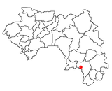
Kamandou Koura is a locality in southeastern Guinea, located near the border with Liberia. It is a neighborhood in the commune of Macenta, in the Macenta Prefecture of the same name and the region of Nzérékoré.
Geography
[edit]Kamandou Koura is located at an altitude of 553 m[1].
It is bounded :
- to the northeast by the Bamala district;
- to the east by the Kamandou-Cité district;
- to the west by the Moilaminidou and Bowa districts.
History
[edit]The founder and leader from 1980 to 2000 of this neighborhood was Mamoudou Kourouma[2], Douty, a Guinean politician born around 1946 in Ourembaya, who died on March 10, 2000 in Kankan and is buried in Ourembaya. He was elected for more than 20 years to head the district.
As a young man, he was the president of the youth of Ourembaya for many years before immigrating to southern Guinea with his uncle Filamoro Kourouma, a customs inspector in Macenta (head of the Badiaro post on the border with Liberia).
Culture
[edit]Kamandou Koura participates in the cultural activities of the urban and prefectural commune of Macenta Prefecture.
There is a video club and a soccer field on site.
Economy
[edit]The founding fathers and the population of Kamandou Koura encouraged all economic activities, especially local businesses.
Kamandou Koura is a neighborhood of traders, and a large part of Macenta's traders live in this neighborhood.
The population of Kamandou Koura also practices agriculture.
Water
[edit]Assisted wells [3]
Today Kamandou Koura has drinking water points and basins on the water sources for women, as well as wells with assisted pulley systems. Kamandou Koura also has functional pumps, although they are not perfect.
Roads
[edit]Roads in the Moilaminidou neighborhood
Road projects have also been initiated.
Schools
[edit]Kamandou Koura Primary School
In partnership with the European Union and Plan Guinea[4], whose premises are located in the Kamandou Koura neighborhood, a modern public primary school was built in 1997[5] .
It includes a private complex, the École Sainte-Thérèse[6], which was originally public under the name of École primaire Kaman Kamara, as well as the college Ouezzin Koulibaly.
Religions
[edit]All faiths are represented in Kamandou Koura. There are two mosques and the home of the Catholic Church of Macenta which is associated with the private complex, Sainte Thérèse.
Notes et references
[edit]- ^ Altitude for Kamandou Koura, Macenta-Centre, Macenta, Guinea [1]
- ^ Moustapha Kourouma. "Mamoudou Kourouma d'Ourembaya in Macenta".
- ^ Moustapha Kourouma. "Water basin housekeeping Kamandou Koura".
- ^ Plan International. "Plan International in Guinea".
- ^ World Places Map Directory. "Primary school of Kamandou-Koura".
{{cite web}}:|author=has generic name (help) - ^ Primary School Sainte Therese. "Primary School Sainte Therese".

