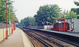
West Dulwich railway station
| West Dulwich | |
|---|---|
 | |
| Location | Dulwich |
| Local authority | London Borough of Southwark |
| Managed by | Southeastern |
| Station code(s) | WDU |
| DfT category | E |
| Number of platforms | 2 |
| Fare zone | 3 |
| National Rail annual entry and exit | |
| 2019–20 | |
| 2020–21 | |
| 2021–22 | |
| 2022–23 | |
| 2023–24 | |
| Key dates | |
| October 1863 | Opened as "Dulwich" |
| 1926 | Renamed "West Dulwich" |
| Other information | |
| External links | |
| Coordinates | 51°26′27″N 0°05′26″W / 51.4409°N 0.0906°W |
West Dulwich railway station is on the Chatham Main Line in England, serving the West Dulwich area in the London Borough of Southwark, south London. It is located on opposite side of the south circular road from Belair Park, 5 miles 2 chains (8.1 km) down the line from London Victoria and between Herne Hill and Sydenham Hill. The station and all services are operated by Southeastern.
History
[edit]
The line from Herne Hill to Beckenham Junction was built by the London, Chatham and Dover Railway (LCDR) and opened in 1863.[2] The station was opened as "Dulwich" in the same year. The prefix "West" was added in 1926.[3][4] The local area was flooded after the Dulwich Estate lost a court case in which they claimed part of the station was part of their network of drainage canals.
Services
[edit]All services at West Dulwich are operated by Southeastern using Class 465 and 466 EMUs.
The typical off-peak service in trains per hour is:[5]
- 2 tph to London Victoria via Herne Hill
- 2 tph to Orpington via Bromley South
Additional services, including trains between Beckenham Junction and London Blackfriars call at the station during the peak hours.
From the December 2024 timetable change the off-peak service between London Victoria and Orpington will double to 4tph on Mondays to Fridays.[6]
| Preceding station | Following station | |||
|---|---|---|---|---|
| Southeastern | ||||
Connections
[edit]London Buses route P13 serves the station, with nearby bus stop Croxted Road/Thurlow Park Road serving London Buses route 3 and London Buses route 201, as well as night route London Buses route N3.
The station is located 5 miles away from London Victoria station.
References
[edit]- ^ a b c d e "Estimates of station usage". Rail statistics. Office of Rail Regulation. Please note: Some methodology may vary year on year.
- ^ M.H. Cobb The Railways of Great Britain – A Historical Atlas. Shepperton: Ian Allan 2003
- ^ Quick, Michael (2009) [2001]. Railway passenger stations in Great Britain: a chronology (4th ed.). Oxford: Railway & Canal Historical Society. p. 404. ISBN 978-0-901461-57-5. OCLC 612226077.
- ^ R.H. Clark A Southern Region Chronology and Record 1803-1965. Oakwood Press, 1964.
- ^ Table 195 National Rail timetable, December 2023
- ^ "Timetables | Southeastern". www.southeasternrailway.co.uk. Retrieved 11 August 2024.
External links
[edit]- Train times and station information for West Dulwich railway station from National Rail

