
Portal:World
The World Portal


The world is the totality of entities, the whole of reality, or everything that exists. The nature of the world has been conceptualized differently in different fields. Some conceptions see the world as unique while others talk of a "plurality of worlds". Some treat the world as one simple object while others analyze the world as a complex made up of parts.
In scientific cosmology, the world or universe is commonly defined as "[t]he totality of all space and time; all that is, has been, and will be". Theories of modality talk of possible worlds as complete and consistent ways how things could have been. Phenomenology, starting from the horizon of co-given objects present in the periphery of every experience, defines the world as the biggest horizon or the "horizon of all horizons". In philosophy of mind, the world is contrasted with the mind as that which is represented by the mind. Theology conceptualizes the world in relation to God, for example, as God's creation, as identical to God or as the two being interdependent. In religions, there is a tendency to downgrade the material or sensory world in favor of a spiritual world to be sought through religious practice. A comprehensive representation of the world and our place in it, as is found in religions, is known as a worldview. Cosmogony is the field that studies the origin or creation of the world while eschatology refers to the science or doctrine of the last things or of the end of the world.
In various contexts, the term "world" takes a more restricted meaning associated, for example, with the Earth and all life on it, with humanity as a whole or with an international or intercontinental scope. In this sense, world history refers to the history of humanity as a whole and world politics is the discipline of political science studying issues that transcend nations and continents. Other examples include terms such as "world religion", "world language", "world government", "world war", "world population", "world economy", or "world championship". (Full article...)
Selected articles -
-
 Effects of climate change are well documented and growing for Earth's natural environment and human societies. Changes to the climate system include an overall warming trend, changes to precipitation patterns, and more extreme weather. As the climate changes it impacts the natural environment with effects such as more intense forest fires, thawing permafrost, and desertification. These changes impact ecosystems and societies, and can become irreversible once tipping points are crossed.
The effects of climate change vary in timing and location. Up until now the Arctic has warmed faster than most other regions due to climate change feedbacks. Surface air temperatures over land have also increased at about twice the rate they do over the ocean, causing intense heat waves. These temperatures would stabilize if greenhouse gas emissions were brought under control. Ice sheets and oceans absorb the vast majority of excess heat in the atmosphere, delaying effects there but causing them to accelerate and then continue after surface temperatures stabilize. Sea level rise is a particular long term concern as a result. The effects of ocean warming also include marine heatwaves, ocean stratification, deoxygenation, and changes to ocean currents. The ocean is also acidifying as it absorbs carbon dioxide from the atmosphere. (Full article...) -

Painting of a turn-of-century trading fair, Hessisches Volksfest (Hessian Folk Festival), 1887, Louis Toussaint (1826–1887), Öl auf Leinwand.
Cultural globalization refers to the transmission of ideas, meanings and values around the world in such a way as to extend and intensify social relations. This process is marked by the common consumption of cultures that have been diffused by the Internet, popular culture media, and international travel. This has added to processes of commodity exchange and colonization which have a longer history of carrying cultural meaning around the globe. The circulation of cultures enables individuals to partake in extended social relations that cross national and regional borders. The creation and expansion of such social relations is not merely observed on a material level. Cultural globalization involves the formation of shared norms and knowledge with which people associate their individual and collective cultural identities. It brings increasing interconnectedness among different populations and cultures. The idea of cultural globalization emerged in the late 1980s, but was diffused widely by Western academics throughout the 1990s and early 2000s. For some researchers, the idea of cultural globalization is reaction to the claims made by critics of cultural imperialism in the 1970s and 1980s. (Full article...) -
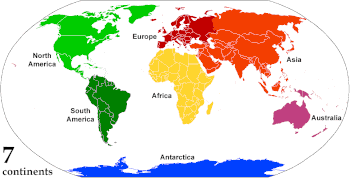
Animated, colour-coded map showing some continents and the region of Oceania (purple), which includes the continent of Australia. Depending on the convention and model, some continents may be consolidated or subdivided.
A continent is any of several large geographical regions. Continents are generally identified by convention rather than any strict criteria. A continent could be a single landmass or a part of a very large landmass, as in the case of Asia or Europe. Due to this, the number of continents varies; up to seven or as few as four geographical regions are commonly regarded as continents. Most English-speaking countries recognize seven regions as continents. In order from largest to smallest in area, these seven regions are Asia, Africa, North America, South America, Antarctica, Europe, and Australia. Different variations with fewer continents merge some of these regions; examples of this are merging North America and South America into America, Asia and Europe into Eurasia, and Africa, Asia, and Europe into Afro-Eurasia.
Oceanic islands are occasionally grouped with a nearby continent to divide all the world's land into geographical regions. Under this scheme, most of the island countries and territories in the Pacific Ocean are grouped together with the continent of Australia to form the geographical region Oceania. (Full article...) -
The Internet (or internet) is the global system of interconnected computer networks that uses the Internet protocol suite (TCP/IP) to communicate between networks and devices. It is a network of networks that consists of private, public, academic, business, and government networks of local to global scope, linked by a broad array of electronic, wireless, and optical networking technologies. The Internet carries a vast range of information resources and services, such as the interlinked hypertext documents and applications of the World Wide Web (WWW), electronic mail, telephony, and file sharing.
The origins of the Internet date back to research that enabled the time-sharing of computer resources and the development of packet switching in the 1960s. The set of rules (communication protocols) to enable internetworking on the Internet arose from research and development commissioned in the 1970s by the Defense Advanced Research Projects Agency (DARPA) of the United States Department of Defense in collaboration with universities and researchers across the United States and in the United Kingdom and France. The ARPANET initially served as a backbone for the interconnection of regional academic and military networks in the United States to enable resource sharing. The funding of the National Science Foundation Network as a new backbone in the 1980s, as well as private funding for other commercial extensions, encouraged worldwide participation in the development of new networking technologies and the merger of many networks using DARPA's Internet protocol suite. The linking of commercial networks and enterprises by the early 1990s, as well as the advent of the World Wide Web, marked the beginning of the transition to the modern Internet, and generated sustained exponential growth as generations of institutional, personal, and mobile computers were connected to the network. Although the Internet was widely used by academia in the 1980s, the subsequent commercialization in the 1990s and beyond incorporated its services and technologies into virtually every aspect of modern life. (Full article...) -
Globalization, or globalisation (Commonwealth English; see spelling differences), is the process of interaction and integration among people, companies, and governments worldwide. The term globalization first appeared in the early 20th century (supplanting an earlier French term mondialisation), developed its current meaning sometime in the second half of the 20th century, and came into popular use in the 1990s to describe the unprecedented international connectivity of the post-Cold War world. Its origins can be traced back to 18th and 19th centuries due to advances in transportation and communications technology. This increase in global interactions has caused a growth in international trade and the exchange of ideas, beliefs, and culture. Globalization is primarily an economic process of interaction and integration that is associated with social and cultural aspects. However, disputes and international diplomacy are also large parts of the history of globalization, and of modern globalization.
Economically, globalization involves goods, services, data, technology, and the economic resources of capital. The expansion of global markets liberalizes the economic activities of the exchange of goods and funds. Removal of cross-border trade barriers has made the formation of global markets more feasible. Advances in transportation, like the steam locomotive, steamship, jet engine, and container ships, and developments in telecommunication infrastructure such as the telegraph, the Internet, mobile phones, and smartphones, have been major factors in globalization and have generated further interdependence of economic and cultural activities around the globe. (Full article...) -
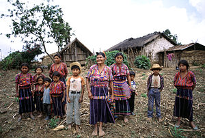
A Kaqchikel family in the hamlet of Patzutzun, Guatemala, 1993
There is no generally accepted definition of Indigenous peoples, although in the 21st century the focus has been on self-identification, cultural difference from other groups in a state, a special relationship with their traditional territory, and an experience of subjugation and discrimination under a dominant cultural model.
Estimates of the population of Indigenous peoples range from 250 million to 600 million. There are some 5,000 distinct Indigenous peoples spread across every inhabited climate zone and continent of the world except Antarctica. Most Indigenous peoples are in a minority in the state or traditional territory they inhabit and have experienced domination by other groups, especially non-Indigenous peoples. Although many Indigenous peoples have experienced colonization by settlers from European nations, Indigenous identity is not determined by Western colonization. (Full article...) -

King Kalākaua
The 1881 world tour of King Kalākaua of the Hawaiian Kingdom was his attempt to save the Hawaiian culture and population from extinction by importing a labor force from Asia-Pacific nations. His efforts brought the small island nation to the attention of world leaders, but sparked rumors that the kingdom was for sale. Critics in Hawaii believed the labor negotiations were just an excuse to see the world. The 281-day trip gave Kalākaua the distinction of being the first monarch to circumnavigate the globe; his 1874 travels had made him the first reigning monarch to visit the United States and the first honoree of a state dinner at the White House. (Full article...)


.jpg)
General images -
-

-
 Tracy Caldwell Dyson, a NASA astronaut, observing Earth from the Cupola module at the International Space Station on 11 September 2010 (from Earth)
 -
 A 2012 artistic impression of the early Solar System's protoplanetary disk from which Earth and other Solar System bodies were formed (from Earth)
 -
 An artist's rendering of a protoplanetary disk (from History of Earth)
 -
 Satellite time lapse imagery of Earth's rotation showing axis tilt (from Earth)
 -

-
 Persepolis, Achaemenid Empire, 6th century BCE
 -
 Standing Buddha from Gandhara, 2nd century CE
 -

-
 A composite image of artificial light emissions at night on a map of Earth (from Earth)
 -
 Angkor Wat temple complex, Cambodia, early 12th century
 -
 A reconstruction of Pannotia (550 Ma). (from History of Earth)
 -
 Pale orange dot, an artist's impression of Early Earth, featuring its tinted orange methane-rich early atmosphere (from Earth)
 -
 The replicator in virtually all known life is deoxyribonucleic acid. DNA is far more complex than the original replicator and its replication systems are highly elaborate. (from History of Earth)
 -
 Geologic map of North America, color-coded by age. From most recent to oldest, age is indicated by yellow, green, blue, and red. The reds and pinks indicate rock from the Archean.
 -
 Artist's rendition of an oxinated fully-frozen Snowball Earth with no remaining liquid surface water. (from History of Earth)
 -
 Dinosaurs were the dominant terrestrial vertebrates throughout most of the Mesozoic (from History of Earth)
 -
The pale orange dot, an artist's impression of the early Earth which might have appeared orange through its hazy methane rich prebiotic second atmosphere. Earth's atmosphere at this stage was somewhat comparable to today's atmosphere of Titan. (from History of Earth)
-
 Notre-Dame de Paris, France
 -
 Lithified stromatolites on the shores of Lake Thetis, Western Australia. Archean stromatolites are the first direct fossil traces of life on Earth. (from History of Earth)
 -
 Artist's impression of the enormous collision that probably formed the Moon (from History of Earth)
 -
 Great Pyramids of Giza, Egypt
 -
 Vitruvian Man by Leonardo da Vinci epitomizes the advances in art and science seen during the Renaissance. (from History of Earth)
 -
 Fall of the Berlin Wall, 1989
 -
 "Lucy", the first Australopithecus afarensis skeleton found, was only 1.06 m (3 ft 6 in) tall.
 -
 View of Earth from the Moon by the Lunar Reconnaissance Orbiter (from Earth)
 -

-
 First airplane, the Wright Flyer, flew on 17 December 1903.
 -
 Graph showing range of estimated partial pressure of atmospheric oxygen through geologic time (from History of Earth)
 -
 Artist's conception of Hadean Eon Earth, when it was much hotter and inhospitable to all forms of life. (from History of Earth)
 -
 COVID-19 pandemic, 2020 (from Human history)
 -
 Earth's history with time-spans of the eons to scale (from History of Earth)
 -

-

-
 A pillar at Göbekli Tepe
 -
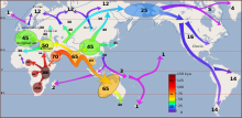
 Peopling of the world, the Southern Dispersal scenario
 -
 A banded iron formation from the 3.15 Ga Moodies Group, Barberton Greenstone Belt, South Africa. Red layers represent the times when oxygen was available; gray layers were formed in anoxic circumstances. (from History of Earth)
 -

-

-
 Chloroplasts in the cells of a moss (from History of Earth)
 -
 Florence, birthplace of the Italian Renaissance
 -
 A 580 million year old fossil of Spriggina floundensi, an animal from the Ediacaran period. Such life forms could have been ancestors to the many new forms that originated in the Cambrian Explosion. (from History of Earth)
 -

-
 Obelisk of Axum, Ethiopia
 -
 Chennakesava Temple, Belur, India
 -

-

-
 An animation of the changing density of productive vegetation on land (low in brown; heavy in dark green) and phytoplankton at the ocean surface (low in purple; high in yellow) (from Earth)
 -
 Machu Picchu, Inca Empire, Peru
 -
 A schematic view of Earth's magnetosphere with solar wind flowing from left to right (from Earth)
 -
 An artist's impression of the Archean, the eon after Earth's formation, featuring round stromatolites, which are early oxygen-producing forms of life from billions of years ago. After the Late Heavy Bombardment, Earth's crust had cooled, its water-rich barren surface is marked by continents and volcanoes, with the Moon still orbiting Earth half as far as it is today, appearing 2.8 times larger and producing strong tides. (from Earth)
 -
 An artist's impression of ice age Earth at glacial maximum. (from History of Earth)
 -

-
 A computer-generated image mapping the prevalence of artificial satellites and space debris around Earth in geosynchronous and low Earth orbit (from Earth)
 -
 Battle during the 1281 Mongol invasion of Japan
 -
 Trilobites first appeared during the Cambrian period and were among the most widespread and diverse groups of Paleozoic organisms. (from History of Earth)
 -
 Ming dynasty section, Great Wall of China
 -
 Olmec colossal head, now at the Museo de Antropología de Xalapa
 -
 A view of Earth with its global ocean and cloud cover, which dominate Earth's surface and hydrosphere; at Earth's polar regions, its hydrosphere forms larger areas of ice cover. (from Earth)
 -
 Last Moon landing: Apollo 17 (1972)
 -
 Earth's axial tilt causing different angles of seasonal illumination at different orbital positions around the Sun (from Earth)
 -
 Great Mosque of Kairouan, Tunisia, founded 670 CE
 -
 Artist's conception of Devonian flora (from History of Earth)
 -

-
 Tiktaalik, a fish with limb-like fins and a predecessor of tetrapods. Reconstruction from fossils about 375 million years old. (from History of Earth)
 -
 A view of Earth with different layers of its atmosphere visible: the troposphere with its clouds casting shadows, a band of stratospheric blue sky at the horizon, and a line of green airglow of the lower thermosphere around an altitude of 100 km, at the edge of space (from Earth)
 -

-

-
 Earth's night-side upper atmosphere appearing from the bottom as bands of afterglow illuminating the troposphere in orange with silhouettes of clouds, and the stratosphere in white and blue. Next the mesosphere (pink area) extends to the orange and faintly green line of the lowest airglow, at about one hundred kilometers at the edge of space and the lower edge of the thermosphere (invisible). Continuing with green and red bands of aurorae stretching over several hundred kilometers. (from Earth)
 -

-
 Japanese depiction of a Portuguese carrack. European maritime innovations led to proto-globalization.
 -
 Yggdrasil, an attempt to reconstruct the Norse world tree which connects the heavens, the world, and the underworld. (from World)
 -
 Artist's impression of a Hadean landscape with the relatively newly formed Moon still looming closely over Earth and both bodies sustaining strong volcanism. (from History of Earth)
 -
 Change in average surface air temperature and drivers for that change. Human activity has caused increased temperatures, with natural forces adding some variability. (from Earth)
 -
 Taj Mahal, Mughal Empire, India
 -
 Image of the physical world, captured by the Hubble Space Telescope (from World)
 -
 Cross-section through a liposome (from History of Earth)
 -
 Shanghai. China urbanized rapidly in the 21st century.
 -
 A map of heat flow from Earth's interior to the surface of Earth's crust, mostly along the oceanic ridges (from Earth)
 -
 Earth's land use for human agriculture in 2019 (from Earth)
 -
Artist's impression of Earth during the later Archean, the largely cooled planetary crust and water-rich barren surface, marked by volcanoes and continents, features already round microbialites. The Moon, still orbiting Earth much closer than today and still dominating Earth's sky, produced strong tides. (from History of Earth)
-
 Empires of the world in 1898
 -
 Benin Bronze head from Nigeria
 -
 A composite image of Earth, with its different types of surface discernible: Earth's surface dominating Ocean (blue), Africa with lush (green) to dry (brown) land and Earth's polar ice in the form of Antarctic sea ice (grey) covering the Antarctic or Southern Ocean and the Antarctic ice sheet (white) covering Antarctica. (from Earth)
 -
 Ajloun Castle, Jordan
 -

-
 Earth's western hemisphere showing topography relative to Earth's center instead of to mean sea level, as in common topographic maps (from Earth)
 -
 Pangaea was a supercontinent that existed from about 300 to 180 Ma. The outlines of the modern continents and other landmasses are indicated on this map. (from History of Earth)
 -
 A reconstruction of human history based on fossil data. (from History of Earth)


.jpeg)

.jpg)


.jpg)


.jpg)


.svg)


Megacities of the world -
.jpg)
Shanghai is a direct-administered municipality and the most populous urban area in China. The city is located on the Chinese shoreline on the southern estuary of the Yangtze River, with the Huangpu River flowing through it. The population of the city proper is the third largest in the world, with around 29.2 million inhabitants in 2023, while the urban area is the most populous in China, with 39.3 million residents. As of 2022, the Greater Shanghai metropolitan area was estimated to produce a gross metropolitan product (nominal) of nearly 13 trillion RMB ($1.9 trillion). Shanghai is one of the world's major centers for finance, business and economics, research, science and technology, manufacturing, transportation, tourism, and culture. The Port of Shanghai is the world's busiest container port.
Originally a fishing village and market town, Shanghai grew in importance in the 19th century due to both domestic and foreign trade and its favorable port location. The city was one of five treaty ports forced to open to European trade after the First Opium War, which ceded Hong Kong to the United Kingdom. This followed the Second Battle of Chuenpi in 1841, more than 60 km (37 mi) east of the Portuguese colony of Macau. Macau was controlled by Portugal following the Luso-Chinese agreement of 1554. The Shanghai International Settlement and the French Concession were subsequently established. The city then flourished, becoming a primary commercial and financial hub of Asia in the 1930s. During the Second Sino-Japanese War, the city was the site of the major Battle of Shanghai. After the war, the Chinese Civil War soon resumed between the Kuomintang (KMT) and the Chinese Communist Party (CCP), with the latter eventually taking over the city and most of the mainland. From the 1950s to the 1970s, trade was mostly limited to other socialist countries in the Eastern Bloc, causing the city's global influence to decline during the Cold War. (Full article...)Did you know -

- ... that Trictrac was the classic tables game of France, just as backgammon is of the English-speaking world today?
- ... that the Guinness World Record for the most consecutive pull-ups is 651 in 87 minutes?
- ... that the heritage-registered Weston House, designed by architect Cecil Wood for George Weston, was damaged in a series of earthquakes in Christchurch and later demolished?
- ... that Boston's World's Museum was a theatre, an aquarium, a menagerie, and a freak show?
- ... that in Korea Job World, children can participate in career-experience scenarios to explore vocational paths?
- ... that Taylor Swift said that her first live album, Speak Now World Tour – Live, was meant to capture what she wanted to "show [...] my kids and my grandkids"?
- ... that after leaving his job promoting Qatar ahead of the 2022 World Cup, Marc Bennett alleged he was tortured before being found hanged in his hotel room?
- ... that British child artist Noah created the backgrounds for paintings by worldwide celebrities including Ed Sheeran?
Countries of the world -

Mauritius, officially the Republic of Mauritius, is an island country in the Indian Ocean, about 2,000 kilometres (1,100 nautical miles) off the southeastern coast of East Africa, east of Madagascar. It includes the main island (also called Mauritius), as well as Rodrigues, Agaléga, and St. Brandon (Cargados Carajos shoals). The islands of Mauritius and Rodrigues, along with nearby Réunion (a French overseas department), are part of the Mascarene Islands. The main island of Mauritius, where the population is concentrated, hosts the capital and largest city, Port Louis. The country spans 2,040 square kilometres (790 sq mi) and has an exclusive economic zone covering 2,300,000 square kilometres (670,000 square nautical miles).
Based on the only surviving map of the Portuguese discoveries dated 1502 called the Cantino planisphere, it is generally accepted that Arab sailors first discovered the uninhabited island, around 975, naming it Dina Arobi. In 1507, Portuguese sailors visited the uninhabited island with the island appearing with the Portuguese names Cirne or Do-Cerne on early Portuguese maps. A Dutch fleet, under the command of Admiral Van Warwyck, landed at what is now the Grand Port District and took possession of the island in 1598, renaming the uninhabited islands after Maurice, Prince of Orange. A succession of short-lived Dutch attempts at permanent settlement took place over a century with the aim of exploiting the local ebony forests, establishing a consistent sugar and arrack production using cane plant cuttings imported from Java together with over three hundred Malagasy slaves, before abandoning their efforts. France took the uninhabited island in 1715, renaming the island "Isle de France". In 1810, the United Kingdom seized the island, and four years later, under the Treaty of Paris, France ceded Mauritius and its dependencies to the United Kingdom. The British colony of Mauritius now included Rodrigues, Agaléga, St. Brandon, the Chagos Archipelago, and, until 1906, the Seychelles. Mauritius and France dispute sovereignty over the island of Tromelin. The treaty failed to mention it specifically. Mauritius became the British Empire's main sugar-producing colony and remained a primarily sugar-dominated plantation-based colony until independence, in 1968. (Full article...)
The Seven Wonders of Wales (Welsh: Saith Rhyfeddod Cymru) is a traditional list of notable landmarks in north Wales, commemorated in an anonymously written rhyme:
The rhyme is usually supposed to have been written sometime in the late 18th or early 19th century by an English visitor to North Wales. The specific number of wonders may have varied over the years: the antiquary Daines Barrington, in a letter written in 1770, refers to Llangollen Bridge as one of the "five wonders of Wales, though like the seven wonders of Dauphiny, they turn out to be no wonders at all out of the Principality". (Full article...)Related portals
Protected areas of the world -
-
-
The Protected areas of New South Wales include both terrestrial and marine protected areas. there are 225 national parks in New South Wales. A number established since the late 1970s followed campaigns by local residents and environmentalists.
Based on the Collaborative Australian Protected Area Database (CAPAD) 2020 data there are 2136 separate terrestrial protected areas with a total land area of 7,696,641 hectares (19,018,810 acres) (9.61% of the state's area). CAPAD data also shows 18 marine protected areas with a total area of 348,849 hectares (862,020 acres), covering 39.63% of NSW waters. (Full article...) -
-
Illinois has a variety of protected areas, including over 123 state-protected areas, dozens of federally protected areas, hundreds of county-level and municipal park areas. Illinois also contains sites designated as internationally important protected areas. These multiple levels of protection contribute to a statewide network of numerous recreation opportunities and conservation schemes, sometimes in a small area. For example, DeKalb County contains a 1,000-acre (4.0 km2) forest preserve system and a 1,500-acre (6.1 km2) state park (Shabbona Lake State Park); within DeKalb County, the DeKalb Park District in the City of DeKalb has a 700-acre (2.8 km2) park system. (Full article...)
-
Protected areas of the European Union are areas which need and/or receive special protection because of their environmental, cultural or historical value to the member states of the European Union.
(Full article...) -
Forests in the state of Himachal Pradesh (northern India) currently cover an area of nearly 37,939 square kilometres (14,648 sq mi), which is about 68.16% of the total land area of the state. The forests were once considered to be the main source of income of the state and most of the original forests were clear felled. The emphasis has shifted, however, from exploitation to conservation. The state government aims to increase forest cover to 50% of the total land area. There have been various projects, including the establishment of protected areas such as National Parks, designed to preserve and expand the forests. (Full article...)
-
-

The sun over the Lake Niassa Reserve
Protected areas in Mozambique are known as conservation areas, and are currently grouped into national parks, national reserves, forest reserves, wildlife utilisation areas (coutadas), community conservation areas, and private game farms (fazendas de bravio). There are also a number of areas that have been declared as protected areas under a variety of different legislation, which for reasons of simplicity are here grouped together as "other protected areas." Under the Conservation Law of 2014 (Law 16/2014 of June 20), protected areas will need to be reclassified into a much more flexible series of new categories which are closer to the international system used by the IUCN. International initiatives such as transfrontier parks are grouped at the end of the page. (Full article...) -

Overview of IUCN Protected area - WAP (W, Arli, Pendjari) area - Niger, Burkina Faso, and Benin
The following is a list of protected areas of Burkina Faso. (Full article...) -
-
Protected areas of Tasmania consist of protected areas located within Tasmania and its immediate onshore waters, including Macquarie Island. It includes areas of crown land (withheld land) managed by Tasmanian Government agencies as well as private reserves. As of 2016, 52% of Tasmania's land area has some form of reservation classification, the majority is managed by the Tasmania Parks & Wildlife Service (about 42% of total Tasmanian land area). Marine protected areas cover about 7.9% of state waters.
Within each classification of reserve there may be a variation of IUCN categories Australia is a signatory to the Convention of Biological Diversity and as such has obligations to report the status of its National Reserve System.IUCN provides on its website a prescription for activities consistent with the categorisation system. Changes made to the Nature Conservation Act 2002 in 2014 permit timber harvesting. These changes made in addition to the already established right to access minerals means that many of the IUCN categorisations assigned to individual reserves in Tasmania are no longer fit for purpose. In addition many reserves have had their reserve status downgraded from a class excluding timber harvesting and mineral extraction to ones where these activities are now permitted. This mis-application of the IUCN protected area categories needs to be remedied or the reserves protected land class under the Nature Conservation Act 2002 should be adjusted to reflect its currently assigned IUCN category. (Full article...) -
A list of protected areas of Oman:
- Al Wusta Wildlife Reserve
- Ra's Al Hadd Turtle Reserve
- Ad Dimaniyat Islands Reserve
- Al Saleel National Park (As Salil Natural Park)
- Jabal Samhan Nature Reserve
- Al Jabal Al Akhdar Scenic Reserve
- Western Hajer Stars Lights Reserve
- Arabian Oryx Sanctuary
- Al Rustaq Wildlife Reserve
- Al Wusta Wetland Reserve
- Jabal Qahwan Nature Reserve
- Al Sareen Nature Reserve
- Ras al Shajar Nature Reserve
- Al Khuwuair Nature Reserve
- Khawrs of the Salalah Coast Reserve
-
This is a list of the nationally designated protected areas of China. There are many forms of protected areas in China. Based on their relative importance, each type of protected area can be further graded into two to three levels (national, provincial and prefectural/county level). Nevertheless, the highest rank for "pocket nature preserve" (social and mass-based), "no-hunting area", "no-fishing area", "no-logging area", "wild medicinal material resources conservation area", "crop germplasm resources conservation area", "forest tree germplasm resources conservation area" or "source water protection area" is practically restricted to provincial level. The local government at county level is also responsible for the delimitation and declaration of "basic farmland protection area" and "basic grassland".
Take note that many protected areas in China have multiple official designations, and the statutory boundaries of these multi-designated PAs may be identical or may vary one from the other. For instance, the boundaries of Huangshan NSHA coincide with those of the Huangshan NGP, whereas Fujian province's Wuyi Mountains NNR, NSHA and NFP are adjacent to each other. In Heilongjiang, 27,642.14 hectares out of 115,340.27 hectares of Huzhong NFP are intersected with the experiment zone of Huzhong NNR. (Full article...) -

Grand Canyon of Yellowstone
The protected areas of the United States are managed by an array of different federal, state, tribal and local level authorities and receive widely varying levels of protection. Some areas are managed as wilderness, while others are operated with acceptable commercial exploitation. , the 42,826 protected areas covered 1,235,486 km2 (477,024 sq mi), or 13 percent of the land area of the United States. This is also one-tenth of the protected land area of the world. The U.S. also had a total of 871 National Marine Protected Areas, covering an additional 1,240,000 sq mi (3,200,000 km2), or 26 percent of the total marine area of the United States. (Full article...) -
Protected areas of Slovenia include one national park (Slovene: narodni park), three regional parks (regijski park), several natural parks (krajinski park), and hundreds of natural monuments (naravni spomenik) and monuments of designed nature (spomenik oblikovane narave). They cover about 12.5% of the Slovenian territory. Under the Wild Birds Directive, 26 sites totalling roughly 25% of the nation's land are "Special Protected Areas"; the Natura 2000 proposal would increase the totals to 260 sites and 32% of national territory. (Full article...)

.jpg)


Selected world maps
-
 United Nations Human Development Index map by country (2016)
 -
 Mollweide projection of the world
 -
 Time zones of the world
 -
 Only a few of the largest large igneous provinces appear (coloured dark purple) on this geological map, which depicts crustal geologic provinces as seen in seismic refraction data
 -
 Index map from the International Map of the World (1:1,000,000 scale)
 -
 The Goode homolosine projection is a pseudocylindrical, equal-area, composite map projection used for world maps.
 -
 1516 map of the world by Martin Waldseemüller
 -
 A plate tectonics map with volcano locations indicated with red circles
 -
 The world map by Gerardus Mercator (1569), the first map in the well-known Mercator projection


World records
- List of Olympic records in athletics
- List of world records in athletics
- List of junior world records in athletics
- List of world records in masters athletics
- List of world youth bests in athletics
- List of IPC world records in athletics
- List of world records in canoeing
- List of world records in chess
- List of cycling records
- List of world records in track cycling
- List of world records in finswimming
- List of world records in juggling
- List of world records in rowing
- List of world records in speed skating
- List of world records in swimming
- List of IPC world records in swimming
- List of world records in Olympic weightlifting
Topics

Continents of Earth | ||||||||
|---|---|---|---|---|---|---|---|---|
| ||||||||
| ||||||||
| ||||||||


| Cenozoic Era (present–66.0 Ma) |
| ||||||||||||
|---|---|---|---|---|---|---|---|---|---|---|---|---|---|
| Mesozoic Era (66.0–252 Ma) |
| ||||||||||||
| Paleozoic Era (252–539 Ma) |
| ||||||||||||
| Proterozoic Eon (539 Ma–2.5 Ga) |
| ||||||||||||
| Archean Eon (2.5–4 Ga) | |||||||||||||
| Hadean Eon (4–4.6 Ga) | |||||||||||||
ka = kiloannum (thousands years ago); Ma = megaannum (millions years ago); Ga = gigaannum (billions years ago). See also: Geologic time scale • | |||||||||||||
| Locations | ||
|---|---|---|
| Related | ||

| |||||||||||||||||||
| |||||||||||||||||||
| |||||||||||||||||||

Economic classification of countries | |||||
|---|---|---|---|---|---|
| Three-World Model | |||||
| Gross domestic product (GDP) |
| ||||
| Gross national income (GNI) | |||||
| Wages | |||||
| Wealth | |||||
| Other national accounts | |||||
| Human development | |||||
| Digital divide | |||||
| Net international investment position (NIIP) | |||||
| Technological |
| ||||
|---|---|---|---|---|---|
| Sociological | |||||
| Ecological |
| ||||
| Biological |
| ||||
| Astronomical | |||||
| Eschatological |
| ||||
| Others |
| ||||
| Fictional | |||||
| Organizations | |||||
Categories

Wikimedia
The following Wikimedia Foundation sister projects provide more on this subject:
-
 Commons
Free media repository -
 Wikibooks
Free textbooks and manuals -
 Wikidata
Free knowledge base -
 Wikinews
Free-content news -
 Wikiquote
Collection of quotations -
 Wikisource
Free-content library -
 Wikispecies
Directory of species -
 Wikiversity
Free learning tools -
 Wikivoyage
Free travel guide -
 Wiktionary
Dictionary and thesaurus


