Rampura Thana
Rampura Thana
রামপুরা থানা | |
|---|---|
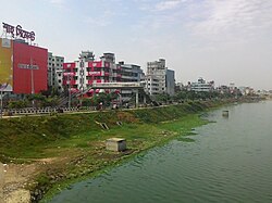
 Rampura in 2019 | |
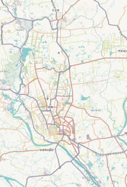
 Expandable map of vicinity of Rampura Thana | |
| Coordinates: 23°45′40″N 90°25′15″E / 23.76124°N 90.4207°E | |
| Country | |
| Division | Dhaka Division |
| District | Dhaka District |
| Established as a thana | 2009 |
| Area | |
• Total | 2.8 km2 (1.1 sq mi) |
| Elevation | 23 m (75 ft) |
| Population | |
• Total | 160,812 |
| • Density | 80,028/km2 (207,270/sq mi) |
| Time zone | UTC+6 (BST) |
| Postal code | 1219 |
| Area code | 02[3] |
Rampura Thana (Bengali: রামপুরা থানা) is a police administrative area (thana) of Dhaka, Bangladesh. It encloses parts of Banasree residential area and Dhaka North City Corporation wards 22 and 23. The major thoroughfare DIT Road passes through this area and connects it to Badda, Ramna & Motijheel thanas.
History
[edit]In 1975, the headquarters of Bangladesh Television have been constructed in Rampura, and the network officially moved its offices and studios from the DIT Bhaban that year.[4] It is the site of GSK Dhaka Half Marathon, sponsored by GSK pharmaceuticals and is a popular marathon in Bangladesh.[5] Rampura KC is the local football club of Rampura and it plays in the Dhaka City Corporation Pioneer Football League.[6] The club qualified for Third Division Football League after a good performance in the Pioneer League in 2008.[7]
Geography
[edit]Rampura Thana has an area of 2.80 km2. It has 17 Mahallas and Mouzas. It borders Gulshan Thana and Badda Thana in the north, Khilgaon Thana in the east and Shahjahanpur Thana in the south. In the west it borders Ramna Thana and Tejgaon Industrial Area Thana.[8] There is also a slum in the thana called Rampura Slum.[9]
The Rampura canal serves as the primary drainage system for eastern Dhaka, facilitating the discharge of rainwater and industrial effluents from the region with the help of a storm water pump. Over time, it has faced challenges related to encroachment and unauthorized land occupation. During the rainy season, it also serves as a transportation route for the conveyance of vegetables and fruits into Dhaka.[10] Rampura has a number of housing projects including Jahurul Islam City (Aftabnagar) housing project and Banasree housing project, both developed by Eastern Housing Limited, which has been accused of filling the canal to increase their land holdings.[11]
Demographics
[edit]According to 2011 Census of Bangladesh, Rampura Thana has a population of 224,079 with average household size of 4.5 members, and an average literacy rate of 78.7% vs national average of 51.8% literacy.[12] There are a number of garment factories in the thana, that have been sites of labour unrest.[13] It is characterized as a neighborhood with relatively low crime rates within Dhaka City.[14]
Education
[edit]Colleges
[edit]- Taltala City College[8]
- City Dental College
- Rampura Ekramunnesa High School and College
- Rajdhani Ideal School & College
- Ideal School & College
- National Ideal School & College.
- Oxford International School.
- Basic Ideal School & College.
Secondary schools
[edit]- Malibagh Chowdhury Para Govt[8]
- Shahid Faruq Iqbal Girls High School
- Proshika School
- Chowdhury Para Madrasa
- Purbo Rampura High School
References
[edit]- ^ "Geographic coordinates of Dhaka, Bangladesh". DATEANDTIME.INFO. Retrieved 7 July 2016.
- ^ National Report (PDF). Population and Housing Census 2022. Vol. 1. Dhaka: Bangladesh Bureau of Statistics. November 2023. p. 386. ISBN 978-9844752016.
- ^ "Bangladesh Area Code". China: Chahaoba.com. 18 October 2024.
- ^ Deepita, Novera (4 February 2006). "From BTV to ETV and beyond: The television revolution". The Daily Star. Retrieved 6 August 2017.
- ^ "Gsk Dhaka Half Marathon 2016 starts at Rampura Bridge tomorrow". The Daily Star. 24 November 2016. Retrieved 1 December 2017.
- ^ "Rampura's fine start". The Daily Star. 23 July 2008. Retrieved 1 December 2017.
- ^ "Rampura into 3rd Division". The Daily Star. 9 August 2008. Retrieved 1 December 2017.
- ^ a b c Akhter, Shamima. "Rampura Thana". en.banglapedia.org. Banglapedia. Retrieved 1 December 2017.
- ^ "Risky living in Rampura Slum". The Daily Star. 24 April 2015. Retrieved 1 December 2017.
- ^ "Encroachers filling Rampura canal". The Daily Star. 26 July 2008. Retrieved 1 December 2017.
- ^ "Fresh onslaught on Rampura Canal". The Daily Star. 13 December 2008. Retrieved 1 December 2017.
- ^ Bangladesh Bureau of Statistics (2011). "Population & Housing Census" (PDF). Bangladesh Government. Archived from the original (PDF) on 3 September 2017. Retrieved 17 April 2015.
- ^ "11 hurt in garment workers-cops clash in Dhaka's Rampura". The Daily Star. 23 March 2017. Retrieved 1 December 2017.
- ^ Dewan, Ashraf; Corner, Robert (2013). Dhaka Megacity: Geospatial Perspectives on Urbanisation, Environment and Health. Springer Science & Business Media. p. 274. ISBN 9789400767355.


