
User:DutchTreat/Projects/Maps
Communities
[edit]- Wikipedia:WikiProject Maps
- Wikipedia:Graphics Lab | commons:Wikipedia:Graphics Lab
- meta:Wikimaps User Group active in 2021. As of 2022-10-29, no activities in 2022.
Dashboard
[edit]- /dashboard status of requests
Help
[edit]- Conventions: SVG template with icons; Location maps; Locator maps (blank); Orthographic maps; Area maps
- Wikipedia:Maps for Wikipedia more on {{Maplink}} automating and other discussions
Books
[edit]Discussion
[edit]- Wikipedia:Requests for comment/Using maps as sources from 19 March 2023
CRS
[edit]- North American Datum - NAD83 zone 18 N for New York City
- Gall–Peters projection#Peters world map controversy
- Gauss-Kruger coordinate system also known as Transverse Mercator projection - delivers high accuracy in zones less than a few degrees in east-west extent.
Tutorials
[edit]- Wikipedia:Creating route maps from OpenStreetMap data using {{Maplink}} with OSM data including routes. See New River (Belize).
- User:JaneVannin/translations/topographic translation from fr-en (last updated in 2011-12-18)
- steps for creating from DEM files in NASA SRTM format using 3DEM and GRASS GIS software
- Wikipedia:Graphics Lab/Resources/Change the colors of a country
People
[edit]- Harrison, Richard Edes (1901–1994) scientific illustrator and cartographer
- Berghaus, Heinrich (1797–1884) German cartographer, surveys of Prussia
- Horthemels,Louise-Magdeleine (1686–1767)
- Kaufmann, Obi (b. 1973), author and illustrator of The California Field Atlas
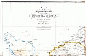
- Lambton, William (c1753–1823)
- Malègue, Hippolyte Hippolyte Malègue (Q55837130) missing Wikipedia article as of Jan 2023
Best examples
[edit]-
 Carte comparative des principales altitudes de la France par département by Hippolyte Malègue (Q55837130) (1897)
 -
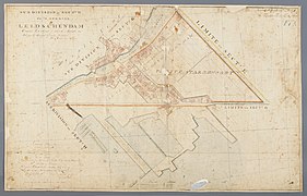 map of the villages of Veur and Leidschendam (NL) province of South Holland, Netherlands (1812-1819) by Dl. Munro van Filpen & Willem Jacob van Campen (Q98520516)
 -
-
 Hadrian's Wall on Ordinance Survey (1964, 2010)
 -
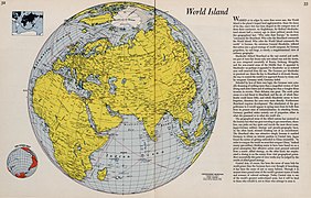 Harrison's World Island (1944), maps in Fortune and published works at "David Rumsey Map Collection".
 -
 NYS relief from topography: ETOPO1 by National Atlas
 -
 Port-Royal-des-Champs, 18th-century axonometric plan engraving by Horthemels (c. 1710)
 -
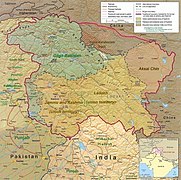 Trans-Karakoram Tract, map of Kashmir region created by US CIA (2004); altered by Fowler & fowler
 -
 map of Trier and surroundings (1692) by Nicolas de Fer
 -


- The Klamath River from The California Field Atlas by Kaufmann (non-free image not allowed outside of article)
Tools
[edit]- bboxfinder.com bounding box
- Generic Mapping Tools (GMT) - toolbox for Earth, Ocean, and Planetary Science, see paper "The Generic Mapping Tools Version 6" Wessel (2019) doi:10.1029/2019GC008515
- Coordinate convetr Degrees to DMS FCC
- GeoJson.io - building and testing geojson
- commons:User:ShareMap
- mapshaper from "Scale and generalization". axismaps.com.
- Gunn Map - creating thematic maps from loaded data
- NASA WorldWind
Templates
[edit]- {{GL Map reply}} - helpful reply to requestor
- {{Map}} - replace the {{Information}} in summery that gets applied by upload wizard
- {{Map conventions}} - footer for WP Map pages
- {{Annotated image}} -
- {{Mali War detailed map}} including info flow between sources, articles and maps
Terms
[edit]- Fluvial processes, see Gulch
- Gazetteer - dictionary
- Gulch - needs more details, plus topo map. Add topo maps from Canada's National Topographic System (NTS). See listing of gulches in Canada "Geographic Terms". geonames.nrcan.gc.ca. Archived from the original on 2011-09-26.. There are 3 types listed in this source:
- Type 1: Deep, steeply graded, V-shaped valley. Examples: Grub Gulch, B.C., 53°02′N 121°42′W / 53.033°N 121.700°W (93 H/4); Gold Bottom Gulch, Y.T., 63°54′N 138°59′W / 63.900°N 138.983°W (115 N & O); Bears Paw Gulch, Man., 49°39′N 98°53′W / 49.650°N 98.883°W (62 G/10) and Arch Gulch, N.S., 45°21′N 64°52′W / 45.350°N 64.867°W(21 H/7)
- Type 2: Narrow cove with steep shoreline. Examples: Guys Gulch, N.L., 49°33′N 53°49′W / 49.550°N 53.817°W (2 F/12); Bear Gulch, N.L., 49°44′N 56°48′W / 49.733°N 56.800°W (12 H/10)
- Type 3: Saltwater channel. Example: Camp Island Gulch, N.S., 44°53′N 62°09′W / 44.883°N 62.150°W (11 D/16)
- Hogback (geology), for example in Colorado Dakota Formation and Grand Hogback, draw 3D diagrams
- Slough (hydrology) wetland, could feed into a lake
North America
[edit]USA Regions
[edit]- Northeast /usa-region-ne
Iowa
[edit]- East Okoboji Lake: OSM Way (113411373) - West Okoboji Lake: OSM - Spirit Lake
North Carolina
[edit]- Durham: Sanborn Fire Insurance Map from Durham, Durham County, North Carolina.
- Plate 45, image 48
- White Rock Baptist Church
- St. Joseph's A.M.E. Church on Fayetteville and St. Joseph St
- Plate 46, image 49
- St. John's Baptist Church
- Lincoln Hospital at E. Proctor and Cozart St
- Plat 56, image 59
- Primitive Baptist Church on E. Pettigrew
- Plate 1, image 2
- North Carolina Mutual Life on W. Parrish St.
- Washington Duke Hotel (unknown if related to Black Wall Street?)
- Plate 203, image 67
- Hayti - district with many black owned business in early 20th century (see article below)
Articles:
Wisconsin
[edit]- Lake Superior improve leading photo: Both existing images have cloud cover, view of Earh from ISS and File:LS-MetOp-B.png, replace with Landsat 9 image without clouds
New Jersey
[edit]New York
[edit]NYC - General
[edit]- New York State Birding Trail: list of places "NYS Birding Trail Locations" "DEC Announces Grand Opening of First Segment of New York State Birding Trail". October 7, 2021., create a map for them? It seems like it's a dynamic list, Add to Birding in New York City?
- Council Districts /nyc-council-districts
- Performance analysis of putting zoom of each district (2 March 2021)
- Historic Districts /nyc-historic-districts
- Monuments /nyc-monuments
- Trees /nyc-trees-by-size
- U. S. Congressional Districts change over time. How to best capture these changes? See New York's 10th congressional district. (a). in Commons, geocoordinates to specific district as Commons Data.map; then (b) in WD use qualifiers to define data ranges for the defined polygons.
NYC - The Bronx
[edit]NYC - Brooklyn
[edit]- Bedford Historic District (Brooklyn) missing May 2024, designated in 2015, see Timeline of Brooklyn
- Coney Island
Use Commons Category:Sanborn maps of Brooklyn > Category:Sanborn maps of Brooklyn published in 1906 (or 1908?)
- Sanborn Fire Insurance Map, 1904-1908 at LOC
- Sanborn Fire Insurance Map, 1915-1933
- not complete at LOC
- Atlas of borough of Brooklyn at NYPL Digital Collection
Wonder Wheel Park built in 1920
- Gowanus Canal
- Gowanus Canal development of 1888 map from Sanborn Fire Insurance Map from Brooklyn, Kings County, New York. Sanborn Map Company, 1886-1888:
- - Volume 1,plate 25, image 51 image 52; plate 26, Image 53 and Image 54; plate 27 image 56; plate 28 image 58; plate 29 image 59 image 60
- Newtown Creek /newtown-creek-brooklyn
- Prospect Park
- Concert Grove Pavilion, 153, East Drive, Brooklyn, Kings County, New York, 11225 40°39′34″N 73°57′51″W / 40.65934°N 73.96414°W

NYC - Manhattan
[edit]- Bazzini - nut company on 339 Greenwich at Jay street, see map Sanborn Map Company, 1890 - 1902, Vol. 1, (1894) sheet 17
- Land of the Blacks - see my page of maps: /nyc-land-of-the-blacks-manhattan
- Lower Manhattan expansion - maps : /nyc-lower-manhattan-expansion
- Seneca Village - my maps /nyc-seneca-village-central-park
NYC - Queens
[edit]- Steinway Village (circa 1880) in Astoria, Queens
NYS
[edit]- Rivers and waterways /nys-rivers
- New York State Wildlife Management Areas, need a map? ; List of National Wildlife Refuges of the United States#New York ; Tug Hill WMA in Montague, New York; Montezuma National Wildlife Refuge (added 2022-08-10)
Oklahoma
[edit]Asia
[edit]Stone Tower
[edit]On the Silk Road, Stone Tower (Ptolemy)
 1 2 3 4 5 | |||||||||||||
| |||||||||||||
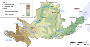
Tibet
[edit]See sample maps on subpage: /Tibet.
Used the Tactical Pilotage Chart Series.
Europe
[edit]Croatia
[edit]England
[edit]- Domesday Book survey of England from 1086
Italy
[edit]- /Venice - Palaces of Venice
Middle East
[edit]
Select images with annotations:


File:Survey of Palestine 1942-1958 1-100,000 14Rafa.jpg

File:Survey of Palestine 1942-1958 1-100,000 17Nitsana.jpg

Turkey
[edit]Oceania
[edit]New Zealand
[edit]Christchurch
[edit]- Christchurch mosque shootings
- Christchurch Hospital at -43.5344, 172.6255
- Linwood Islamic Centre at -43.532389, 172.672556
- Al Noor Mosque, Christchurch at -43.532944, 172.611722


Wellington Region
[edit]- Wellington Region request

Follow-up on Old revision of Wikipedia:Graphics Lab/Map workshop/Archive/Aug 2021#Request: Location Map of Wellington, New Zealand 2021-09-08 from GL/Map Workshop request