Jump to content

User:DutchTreat/Projects/Maps/nys-rivers

From Wikipedia, the free encyclopedia

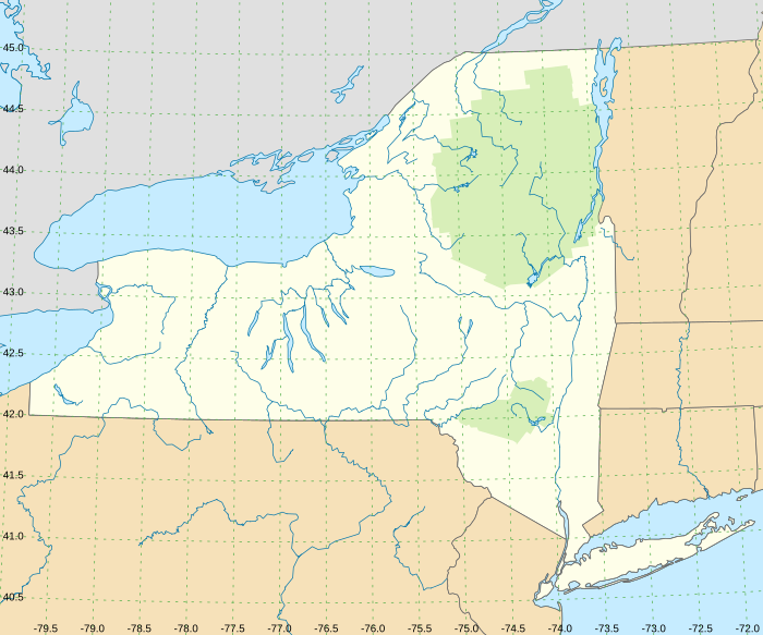
Lambert conformal conic projection

NYS Rivers, Creeks and Lakes
Place OSM WD Notes
Allegheny River 2182454 Allegheny River (Q686021)
Ashokan Reservoir Lower 3289973 and Upper 6281964 Ashokan Reservoir (Q4805816) Lower Ashokan Reservoir and Upper Ashokan Reservoir
Beaver River (Black River tributary) 134124502 Beaver River (Q4878158)
Black Lake (Oswegatchie River tributary) 3360953 Black Lake (Q3595739)
Black River 5454395 Black River (Q880495)
Canadarago Lake 1542200 Canadarago Lake (Q5029545)
Canandaigua Outlet 323176096 Canandaigua Outlet (Q16890060)
Cattaraugus Creek 12133885 Cattaraugus Creek (Q5054054)
Chautauqua Lake 12234902 Chautauqua Lake (Q1068465)
Chadakoin River 136079994 Chadakoin River (Q14706216) Connected to Chautauqua Lake
Chenango River 3339173 Chenango River (Q681278)
Chemung River 6658629 Chemung River (Q900828)
Clyde River 2192736 Clyde River (Q16890469)
Cohocton River Cohocton River (Q5141388)
Conewango Creek 11263827 Conewango Creek (Q5159565) Creek, not a River
Connecticut River
Cranberry Lake 125386 Cranberry Lake (Q5181892)
Delaware River - East Branch 2165271 East Branch Delaware River (Q5327909)
Delaware River - West Branch 2165272 West Branch Delaware River (Q14951265)
Esopus Creek 11965046 Esopus Creek (Q3058095)
Genesee River 2191107 Genesee River (Q1422687)
Great Sacandaga Lake 1085739 Great Sacandaga Lake (Q5599903)
Hudson River 2148192 Hudson River (Q3140)
Indian River (Black Lake) 406109 Indian River (Q30606662) a tributary of the Oswegatchie River in far northern New York, in Lewis County

251110592 north State 3 + 251110593 south State 3 Others:

Keuka Lake Outlet 114718478 Keuka Lake Outlet (Q30625014) usgs
La Chute River 13666017 La Chute (Q1798702) from Lake George to Lake Champlain
Lake George (New York) 179635 Lake George (Q1495651)
Mettawee River 10959271 Mettawee River (Q6825461) should end at lake (via canal)
Mohawk River 2191460 Mohawk River (Q1345896)
Ninemile Creek 14181721 Ninemile Creek (Q7038494) usgs, still an issue with WD in OSM as of 2022-05-27
Oak Creek (203048263) Oak Creek (Q48742813) Oaks Creek from Canadarago Lake to Susquehanna River; not at 42.6, -74.7 OSM labeled as Schenevus Creek, OSM is missing wikidata tag
Oneida River 2191461 Oneida River (Q7093674)
Onondaga Lake 2321824 Onondaga Lake (Q3825751) usgs
Oswegatchie River 5454477 Oswegatchie River (Q3357529)
Oswego River 2191462 Oswego River (Q2036553)
Otisco Lake Otisco Lake (Q458210) usgs
Otsego Lake 13539072 Otsego Lake (Q657370)
Owasco River 14181705 Owasco River (Q7114296) usgs
Raquette River 139157389 Raquette River (Q3930308)
Sacandaga River 13666018 Sacandaga River (Q7396568) Specular-Wells - Wells-Northville / [1] Northhampton / [2]
Saranac River 7400653 (no Q)
Schenevus Creek 247350996 (Q30066194)) fed by Oak Creek
Schoharie Creek 9955742 Schoharie Creek (Q7432016)
Seneca River Seneca River (Q7450332)
Skaneateles Creek 10106525 Skaneateles Creek (Q7533922) usgs
St. Regis River 737964774 Rivière Saint-Régis (Q7591594)
Stillwater Reservoir 11313381 Stillwater Reservoir (Q30623259)
Susquehanna River 3339284 Susquehanna River (Q27538) Connects to Otsego Lake in the wrong place?
Susquehanna River - North Branch
Tioga River 3459119 Tioga River (Q7808710)
Tonawanda Creek 2192768 Tonawanda Creek (Q7820744)
Wallkill River (Q2543032))
West Canada Creek . . 276137552 - 275817164 - 135923779 Prospect to Deerfield

TBD

[edit]
  • short Onondaga Outlet or Onondaga Lake Outlet || partial fix, no WD, no WP || || usgs

PA Rivers

[edit]

source 42°55′57″N 75°01′39″W / 42.9325°N 75.0275°W / 42.9325; -75.0275 mouth 42°19′00″N 75°24′36″W / 42.3168°N 75.41°W / 42.3168; -75.41

Map
Map
mouth is located in New York
mouth
mouth
mouth (New York)

Parks

[edit]

Validate

[edit]

Test 1 - grid

[edit]

Test 2 - original

[edit]
DutchTreat/Projects/Maps/nys-rivers (New York Adirondack Park)

Test 3 Grid - Lat

[edit]
DutchTreat/Projects/Maps/nys-rivers is located in USA New York rivers
-80
-80
-79
-79
-78
-78
-77
-77
-76
-76
-75
-75
-74
-74
-73
-73
-80
-80
-79
-79
-78
-78
-77
-77
DutchTreat/Projects/Maps/nys-rivers (USA New York rivers)
NYS rivers with grid

Test 4 Grid - Long

[edit]
DutchTreat/Projects/Maps/nys-rivers is located in USA New York rivers
42.5
42.5
42
42
41
41
43
43
44
44
45
45
45
45
44
44
43
43
42
42
41
41
DutchTreat/Projects/Maps/nys-rivers (USA New York rivers)

Distance

[edit]

Transform

[edit]

Help:Math

X

[edit]

from $2 (longitude)

Y adjustment ::= sloping lines with positive slope to the West (left) of midLong; zero at midLong; and negative slope to the East (right) of midLong

Y

[edit]

from $1 (latitude)

X adjustment ::= sloping lines with negative slope to West (left) of midLong; 0 at midLong ; and positive slope to East (left) of midLong

Notes

[edit]